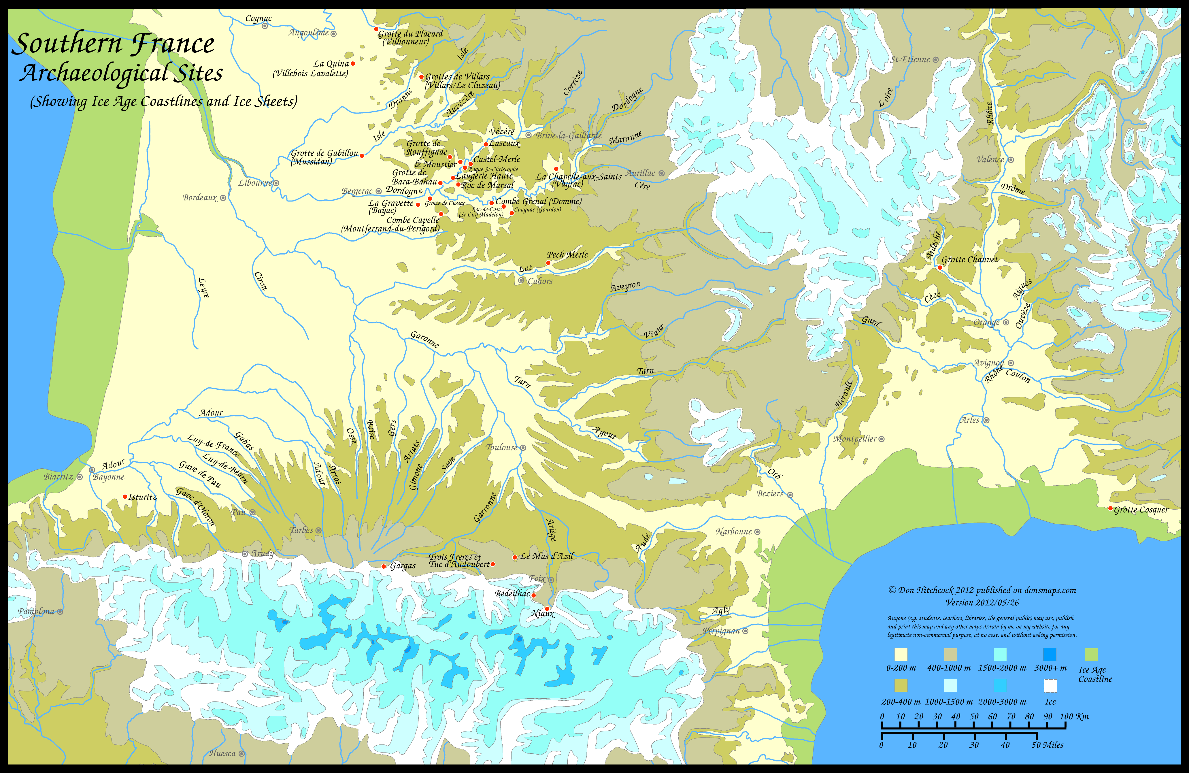
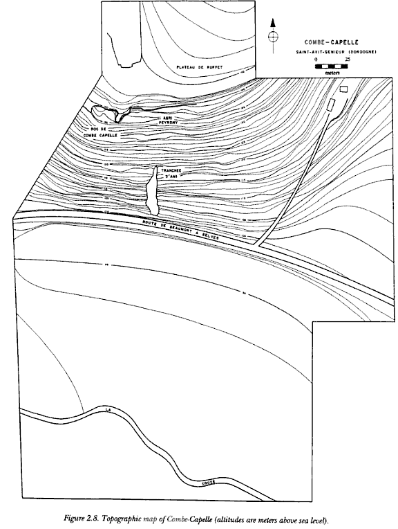
Combe-Capelle, a Neanderthal site in Southern France
Combe-Capelle is a Mousterian / Neanderthal site situated in the Couze valley in the Périgord region of Southern France. Henri-Marc Ami carried out excavations there from the late 1920s until his death in 1931.

Combe-Capelle
Photo: Don Hitchcock 2008
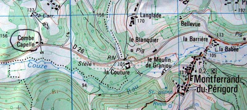

Combe-Capelle location map and cover. Combe-Capelle is slightly out on the map, it is on the east, not to the west of the small side road shown on the map.
The topographical maps are fairly easy to get in the South of France (try tobaccanists and newsagents) and are very useful for navigating when trying to locate archeological sites.
Photo: Don Hitchcock, of the IGN map, Carte de Randonné Beaumont-du-Périgord.
Note - Use this pdf file if you wish to print this map on a single sheet of paper.
Photo: Don Hitchcock version 2012/05/26

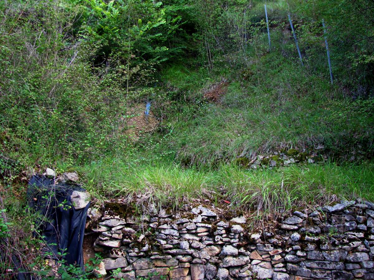
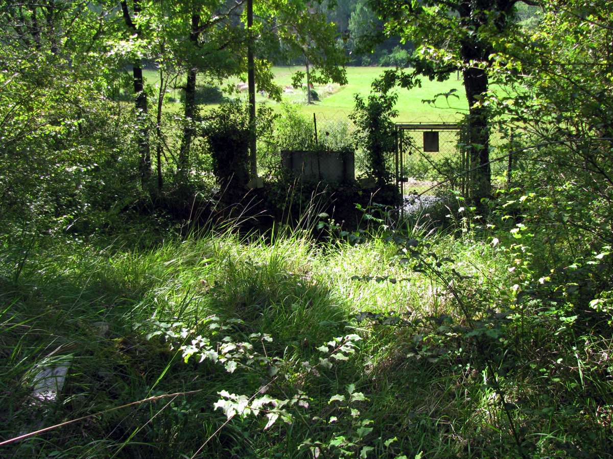
It is easy to miss the gate to the site while driving past. I was very fortunate to be there at the time when an official from the Ministry for Culture was making a once yearly visit to check on the site. Thus I was given a conducted tour while the official made his inspections. I was very grateful for this opportunity.
It is possible that the stone house on the left is the original house shown on the Peyrony (1943a) map below, and labelled as "Combe Capelle". The building shown on Peyrony's map may also be the ruins of an ancient chapel, whence the name Combe Capelle was derived.
Photo: Don Hitchcock 2008

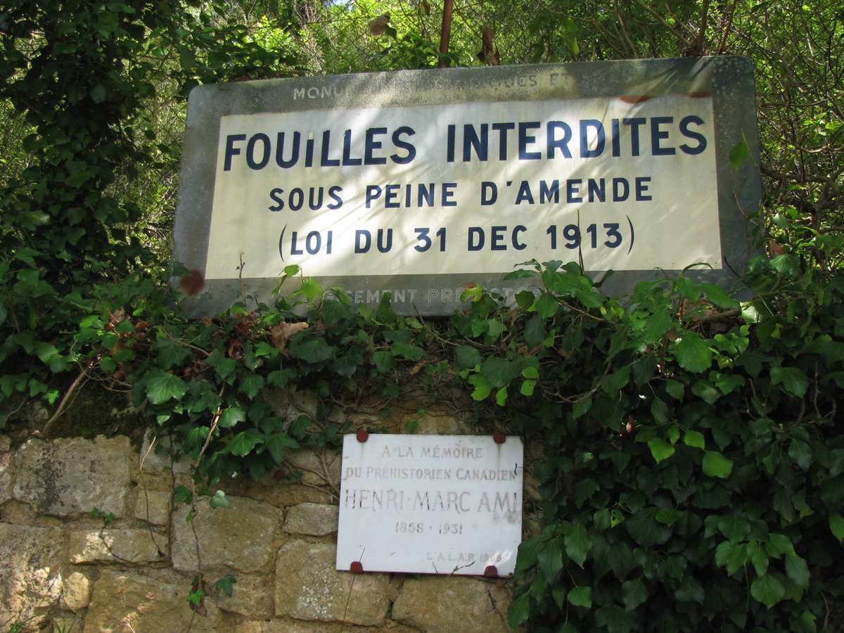
The site is surrounded by a fence. The small sign is in memory of Henri-Marc Ami, a French Canadian archeologist who carried out excavations there from the late 1920s until his death in 1931.
Photo: Don Hitchcock 2008
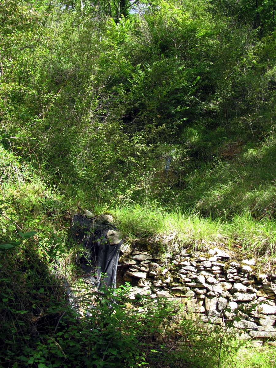
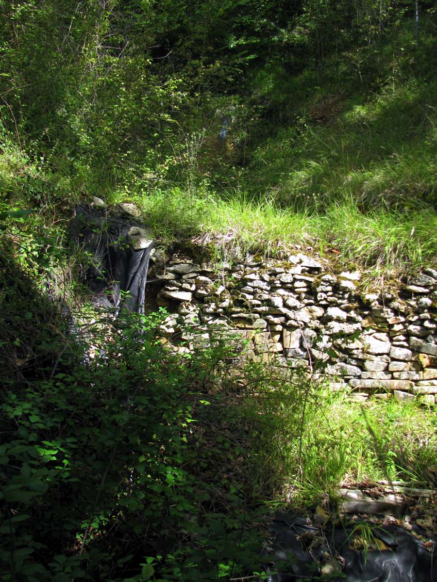

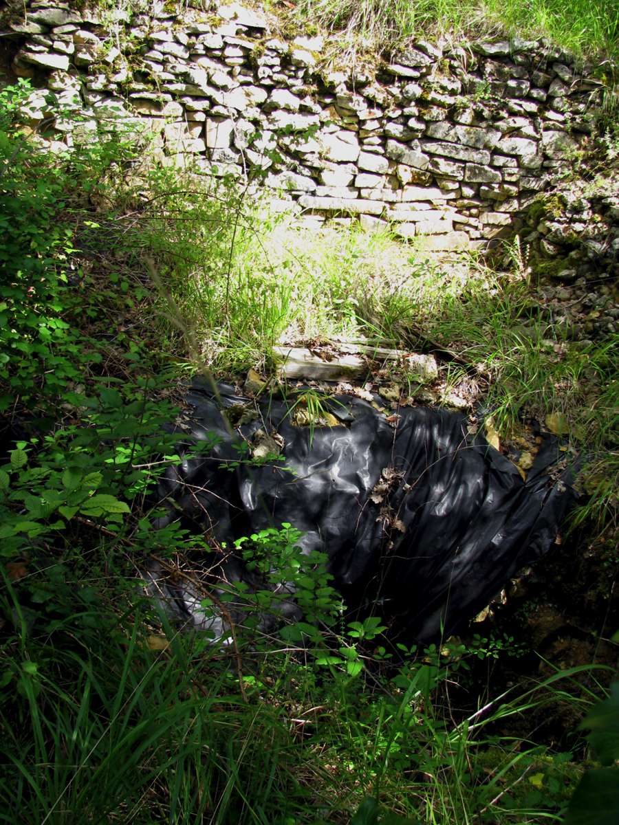
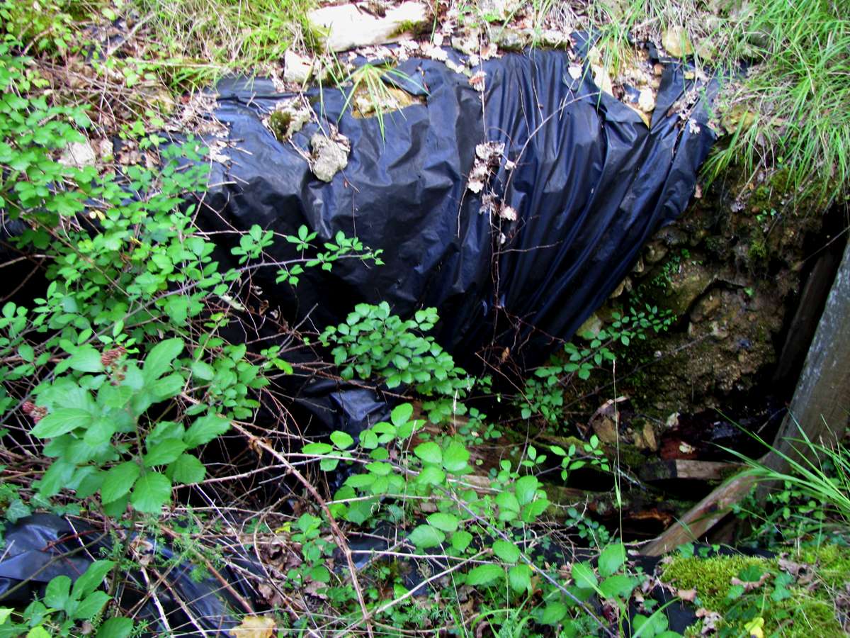
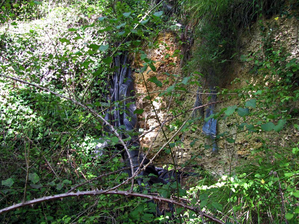
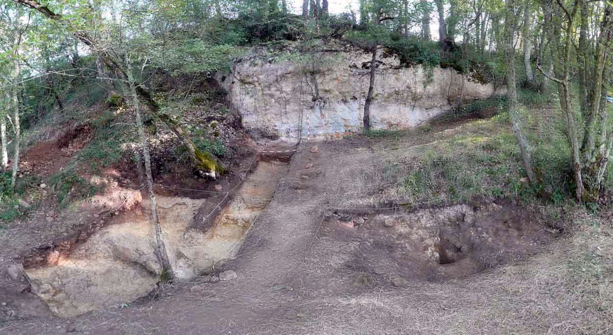
These photographs document the huge trench dug by Henri-Marc Ami, recognisable as the sections protected by stone walls. The black plastic covers areas dug by scientists more recently.
Photo: Don Hitchcock 2008

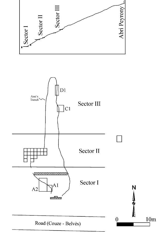
Plan of Combe-Capelle Bas, showing locations of various excavation units in relation to the outlines of Ami's trench. The two datums and the horizontal angle between them define the global cooordinate system used during the excavation.
Photo and Text: Dibble et al (1995)
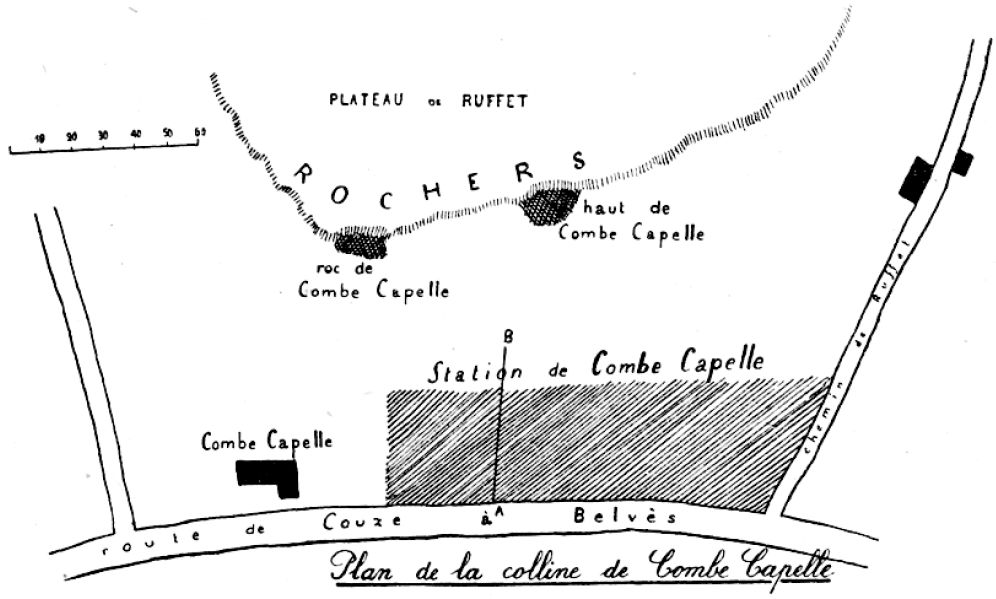
Plan de la colline de Combe-Capelle
Haut de Combe-Capelle is sometimes called Abri Peyrony.
Photo: Peyrony (1943a)
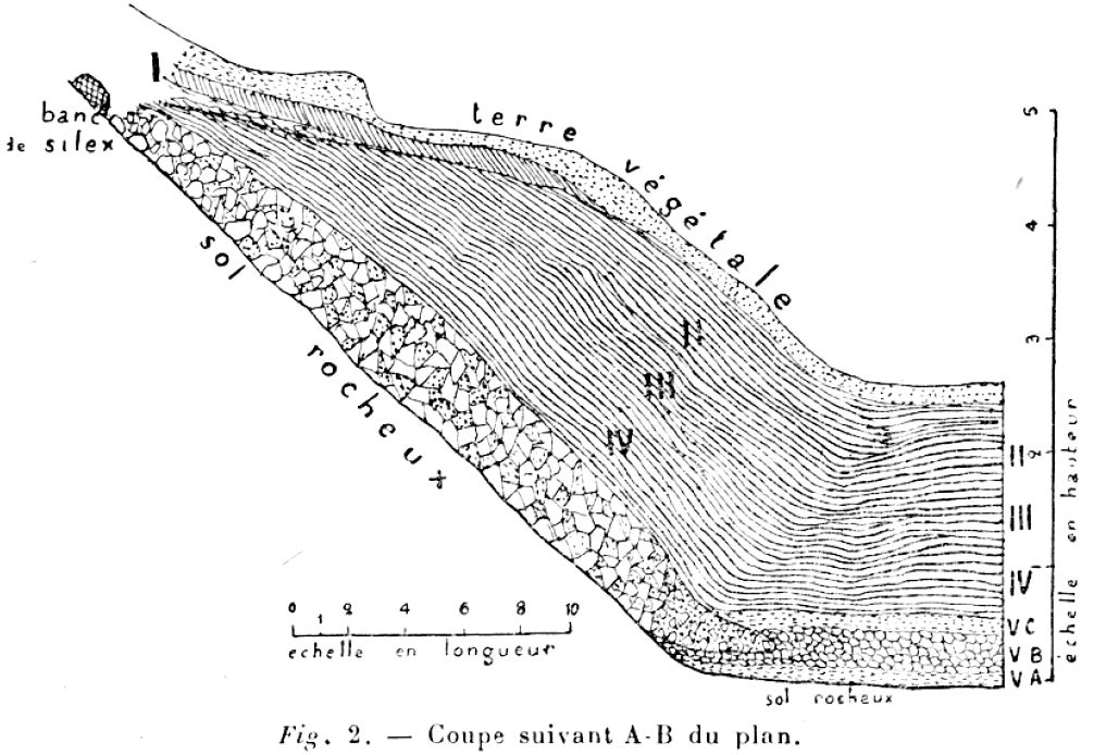
Coupe AB Combe-Capelle
This is the stratigraphy along the line AB on the map above.
Photo: Peyrony (1943a)
At its greatest steepness, the bedrock is inclined at 45° to the horizontal, but at 11 metres from the road the bedrock is at a much more gentle slope.
On the bedrock is:
1. A layer of reddish clay-limestone 10 cm in average thickness, which appears to be have been deposited by a stream, after completion of the carving of the valley. On its surface are embedded fragments of worked flint (Va.)
2. Limestone gravel with a thickness of 30 cm, with a few rounded siliceous cobbles, directly superimposed (Vb).
3. Then comes a reddish clay level of 15 cm, appearing to be another deposit from a flooding creek, which on the surface, and penetrating sometimes, we find an industry the same as that found at the base (Vc).
4. Spreading above this, an important archeological deposit which varies between 200 and 250 cm in thickness, depending on the exact locations considered.
5. On the surface, following the inclination of the slope, we find many flint pieces with crushed edges, similar to those reported in le Moustier and la Micoque.
6. Everything is covered in part by the last archeological level which underlies and mixes with the topsoil.
Text above from: Peyrony (1943a)
English translation from the French: Don Hitchcock

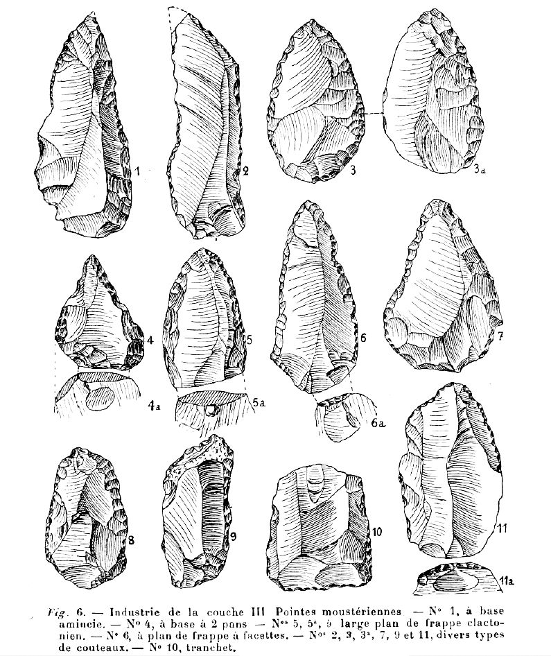
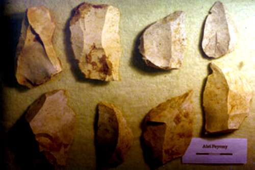
Layer I Industry
Couche I
Nos 1, 2, and 5 cordiformes, or heart shaped all purpose tools, the Swiss Army Knife of the Mousterian industry.
No 3 blade knife.
No 4 and 9 knife-scrapers.
No 6 burin, used for making holes in leather, for example.
Nos 7 and 8 Mousterian points.
Photo: Peyrony (1943a)
Text: translated and adapted from Peyrony (1943a)
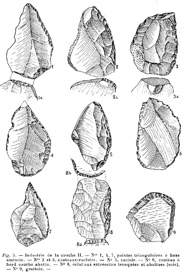
Layer II Industry
Couche II
Nos. 1, 4, 7 triangular points with thin bases.
Nos. 2 and 3 knife-scrapers.
No. 5 scraper.
No. 6 knife with worn-out curved edge.
No. 8 flake with truncated, worn ends.
No. 9 scraper.
Photo: Peyrony (1943a)
Text: translated and adapted from Peyrony (1943a)
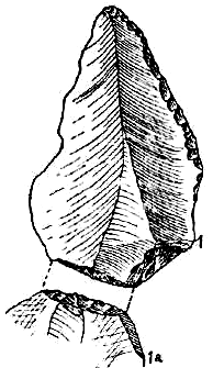
Note that the point 1 in the diagram above, shown again at the far left, is a classic Levallois point. You can clearly see the remains of the striking platform and the three flakes taken off in preparation before the final blow severing the flake from the core.
← To see an excellent animation of the sequence of making such a point, click on the image on the near left.
The point 1 has been later modified by retouch along the right hand edge, presumably after it had become dull through use, or possibly to modify its shape. Not all flakes come off exactly as one would wish, as seen in the idealised sequence of the animation.
Photo: (left) Peyrony (1943a)
Photo: Eshleman (2003) Photo: (right) Wikimedia commons, José-Manuel Benito Álvarez
Date: 3 January 2007
Permission: This file is licensed under the Creative Commons Attribution-Share Alike 2.5 Generic license.
Layer III Industry
Couche III - Mousterian points
No. 1 point with a thin base.
No. 4 point with two bases.
No. 5, 5a point with a broad (striking platform) base on the Clactonian plan, usually associated with much older flints. The Clactonian industry involved striking thick, irregular flakes from a core of flint.
No. 6 point showing the striking platform.
No. 2, 3, 3a, 7, 9 and 11 different types of knives.
No. 10 tranchet. A tranchet flake is a characteristic type of flake removed by a flintknapper during lithic reduction. It involves removing a flake parallel to the final intended cutting edge of the tool which creates a single straight edge as wide as the tool itself. It is found in some Acheulean assemblages, and handaxes created using the method are called tranchet axes.
Photo: Peyrony (1943a)
Text: translated and adapted from Peyrony (1943a) with additional information from Wikipedia.
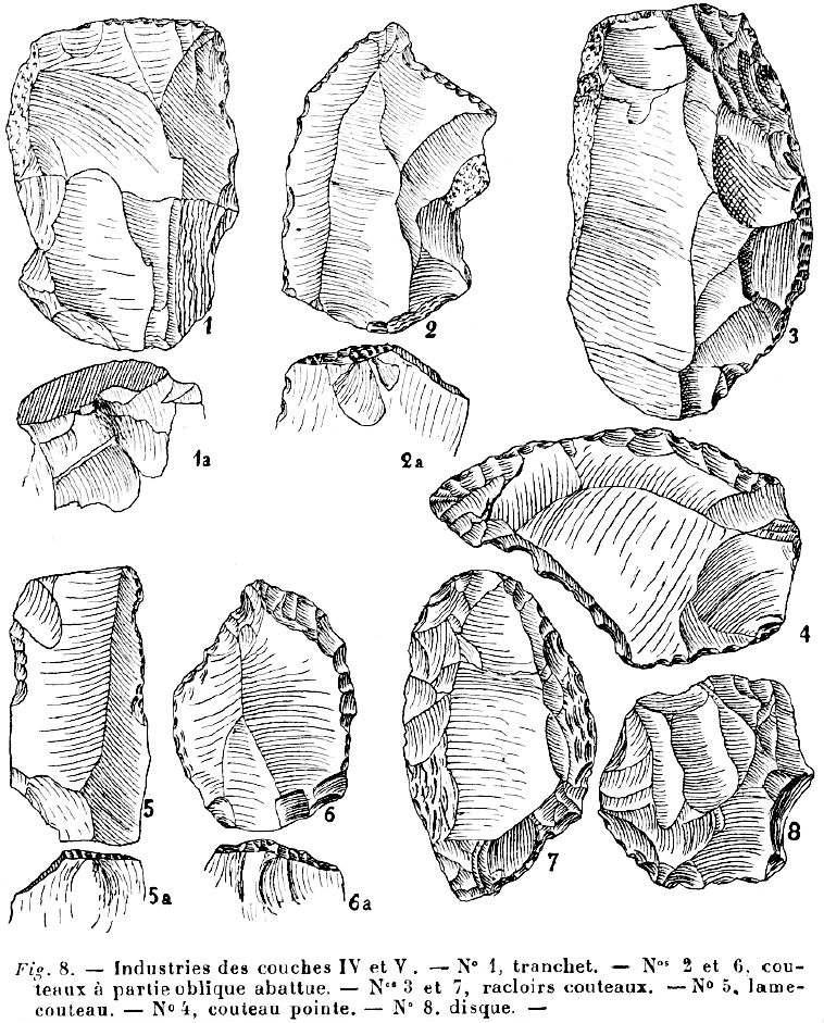
Layer IV and V Industry
Couche IV and V
No. 1 tranchet. A tranchet flake is a characteristic type of flake removed by a flintknapper during lithic reduction. It involves removing a flake parallel to the final intended cutting edge of the tool which creates a single straight edge as wide as the tool itself. It is found in some Acheulean assemblages, and handaxes created using the method are called tranchet axes.
Nos. 2 and 6 knives with the oblique edge worn out.
Nos. 3 and 7 knife-scrapers.
No. 4 knife-point.
No. 5 blade-knife.
No. 8 disc.
Photo: Peyrony (1943a)
Text: translated and adapted from Peyrony (1943a) with additional information from Wikipedia.
Animals
In the whole of the layers II to V, there were found just three skeletons of Marmots, dead in their own burrows, but which were not part of the archeological remains, two fragments of jaws of bovids, as well as some other bovid bones, and two horse teeth.
Text above: Peyrony (1943a)
Text below from:
http://www.oldstoneage.com/cc/AmiExc.htm
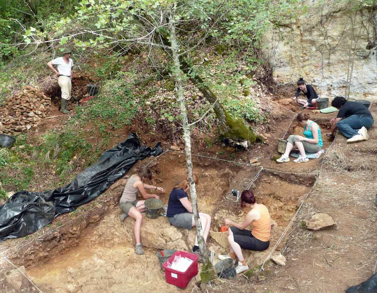
At the suggestion of Peyrony, Ami excavated a trench in this area that began just above the road and continued upslope in the direction of Abri Peyrony. The size of this trench, which appears to have been quite irregular, is enormous: it is about 35 m in length and varies in width between a little over 2.5 m at the top (i.e. furthest upslope) to a maximum width of about 10 m in its central portion and it is approximately 8 m wide at its base. The average thickness of the archaeological deposits is about 3 m. This represents approximately 700 m3 of deposit, most of which was excavated between 1926 and 1931.
Looking downhill towards the road, from the Henri-Marc Ami trench.
Photo: Don Hitchcock 2008
Valladas et al (2003)
Abstract:
The Middle Paleolithic site of Combe-Capelle Bas, France, is known primarily from the excavations of Ami in the early part of the 20th century and more recently from the excavations of Dibble and Lenoir. Up to now, the only dates available for the site were based on geologic and paleoclimatic data. Most recently, Texier and Bertran suggest that the formation of the principal Mousterian deposits date to prior to OIS 6 and likely represent OIS 8 or even 10. The results of TL dating of burnt flints from these same deposits (Levels I-1D, I-1E, and I-2B), reported here, contradict this finding. They indicate an age of between 37 to 60 ka with six of the seven flints falling between 50–60 ka. This date fits well with Mousterian sites previously dated in this region of France.
Plan view of Combe-Capelle showing Ami's trench and
Dibble/Lenoir units. The inset shows a south–north profile of the
hillside from the base of the slope to the Abri Peyrony at the base of
the plateau.
The flints collected for TL dating were from the A1 and A2 units in Sector I.
Photo and text: Valladas et al (2003)
Flints in archeological strata act as dosimeters for the natural radiation received from internal and environmental sources during the burial time.
When a flint is heated to a sufficiently high temperature (ca. 450°C) the effects of prior irradiation are erased and after cooling it begins storing the radiation energy received since the last heating. If the annual radiation dose received by such a flint can be determined, the thermoluminescence (TL) measurement of the total accumulated dose (paleodose) makes it possible to estimate how long ago a hearth, for example, into which the flint had fallen was abandoned. The thermoluminescence method is particularly useful for dating Middle Paleolithic sites beyond the range of radiocarbon method and has in the past provided age-estimates for several important Mousterian sites in Europe and the Near East.
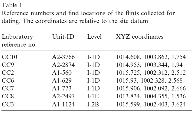
The burnt flint specimens discussed in this article were collected during the Dibble and Lenoir excavations at Combe-Capelle Bas from Levels I-1D to I-2B of Sector I (excavation Units A1 and A2). Among the ten flints selected for TL analysis, only seven were sufficiently heated to be datable. Of these, five specimens came from Level I-1D and one sample each from Levels I-1E and I-2B, respectively (Table 1). The flint find locations are indicated on the section presented in Fig. 3. The industries of these three levels are technologically and typologically very similar and best classified as Typical Mousterian, rich in notched tools.
Annual dose-rates measurement
In 1990, seven CaSO4:Dy dosimeters were placed for one year to measure the gamma and cosmic dose-rates in Levels I-1D, 1-2A, and I-3A (see Fig. 3). The distance between each flint-find location and the nearest dosimeters usually ranged from 0.2 to 1 m.
One sample, CC2, gave a much younger age, but the six other samples are compatible and show no noticeable variation with their burial depth (Levels I-1D to I-2B). Such agreement suggests that all six were burned within a narrow time interval and allows us to compute the mean weighted age of the individual results, with the statistical and systematic errors being treated separately. The mean age of 51.8 ±3.0 ka (at one sigma level) indicates that the fires in which the flints were burnt belong to the first part of OIS 3.
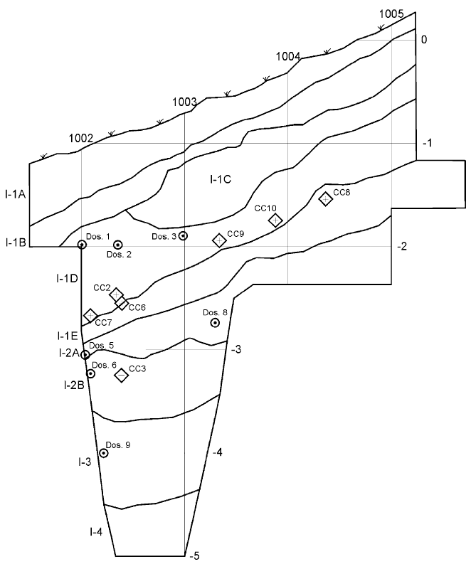
West section of Units A1 and A2 with the locations of the
burnt flint specimens and of the dosimeters. Elevations and the Y
coordinates (across the top) are relative to the site datum.
Photo and text: Valladas et al (2003)
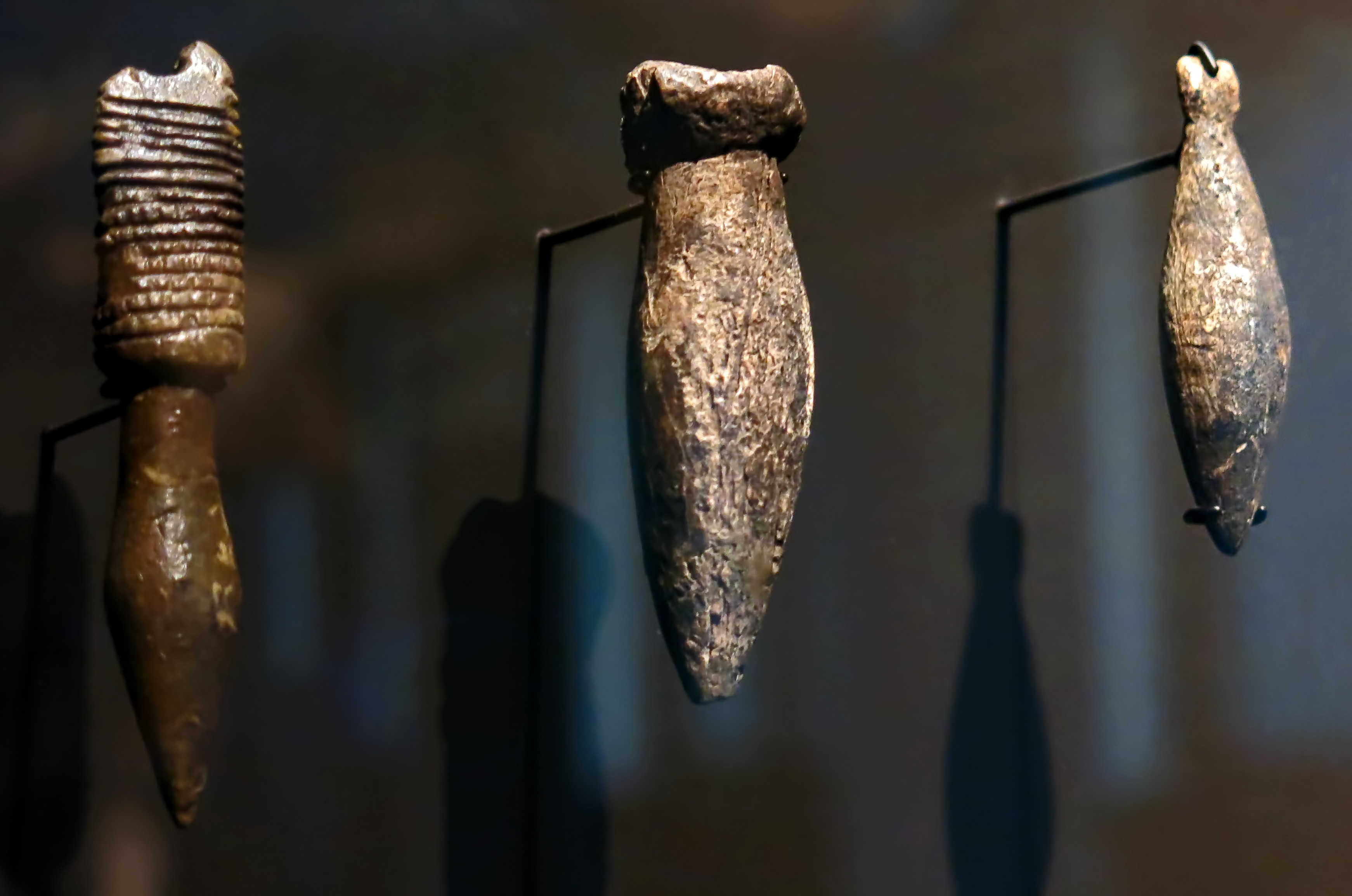
Three decorated pendants from Combe Capelle of mammoth ivory, from the Aurignacian, circa 32 000 BP.
Photo: Don Hitchcock 2015
Source: Original, Staatliche Museen zu Berlin, Neues Museum, Germany
Text: © Card at the Staatliche Museen zu Berlin (CC BY-NC-SA 3.0 DE)
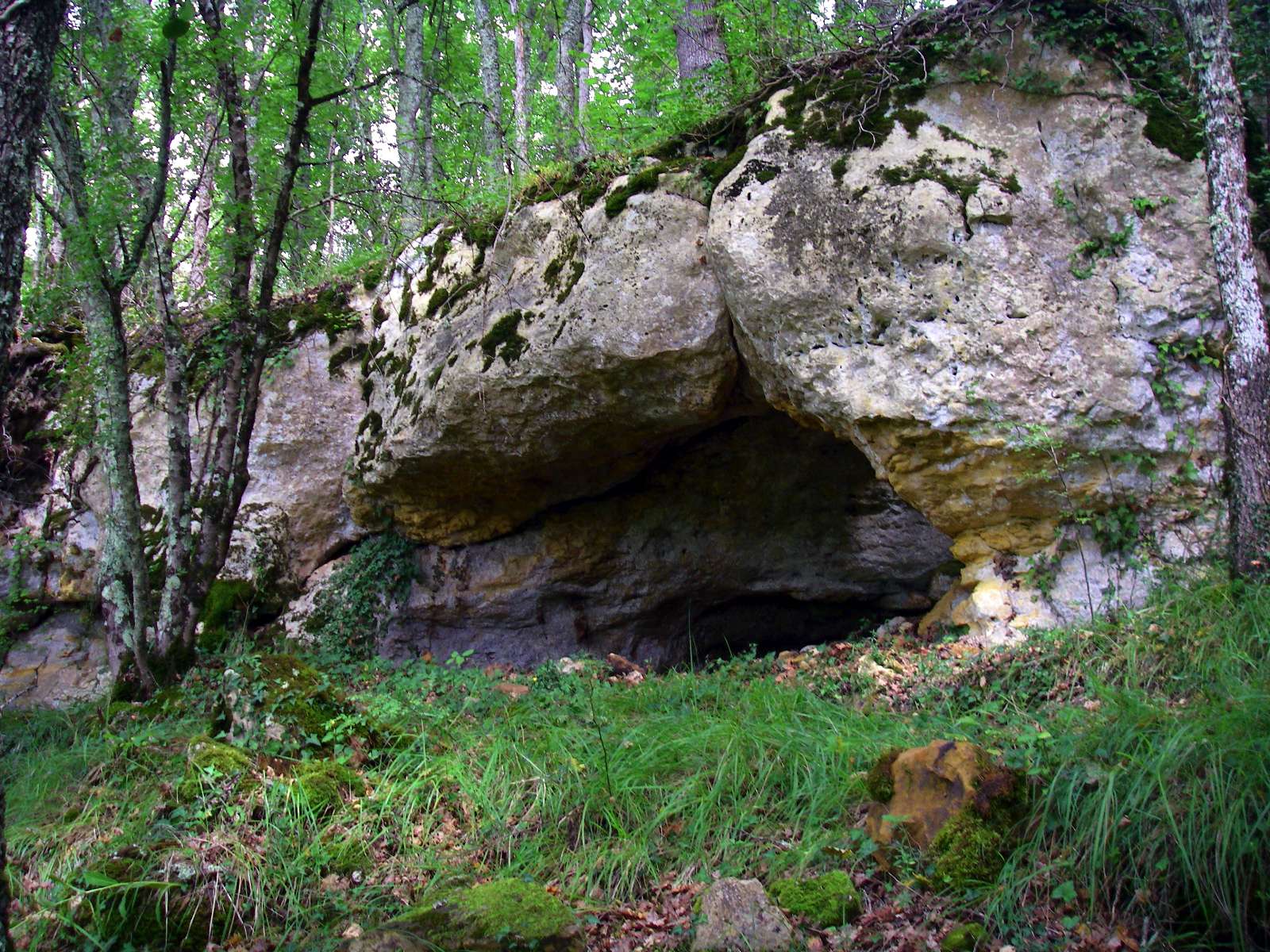
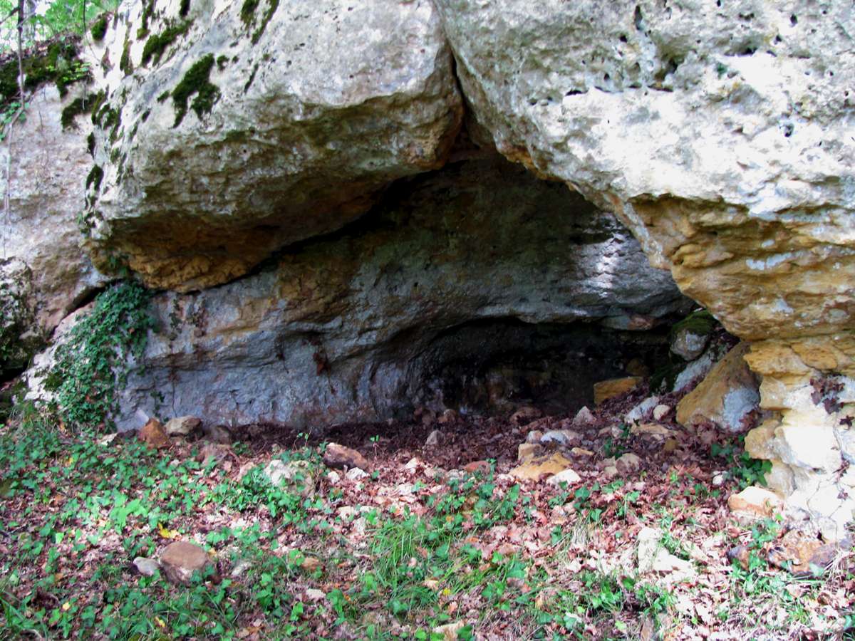
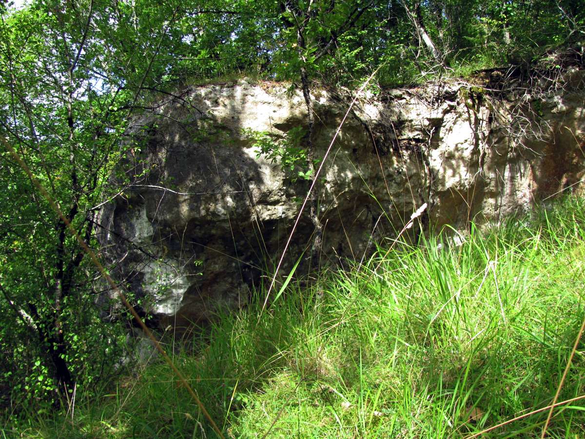
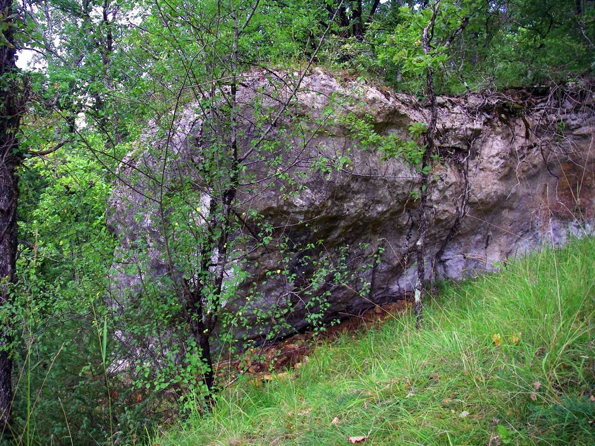
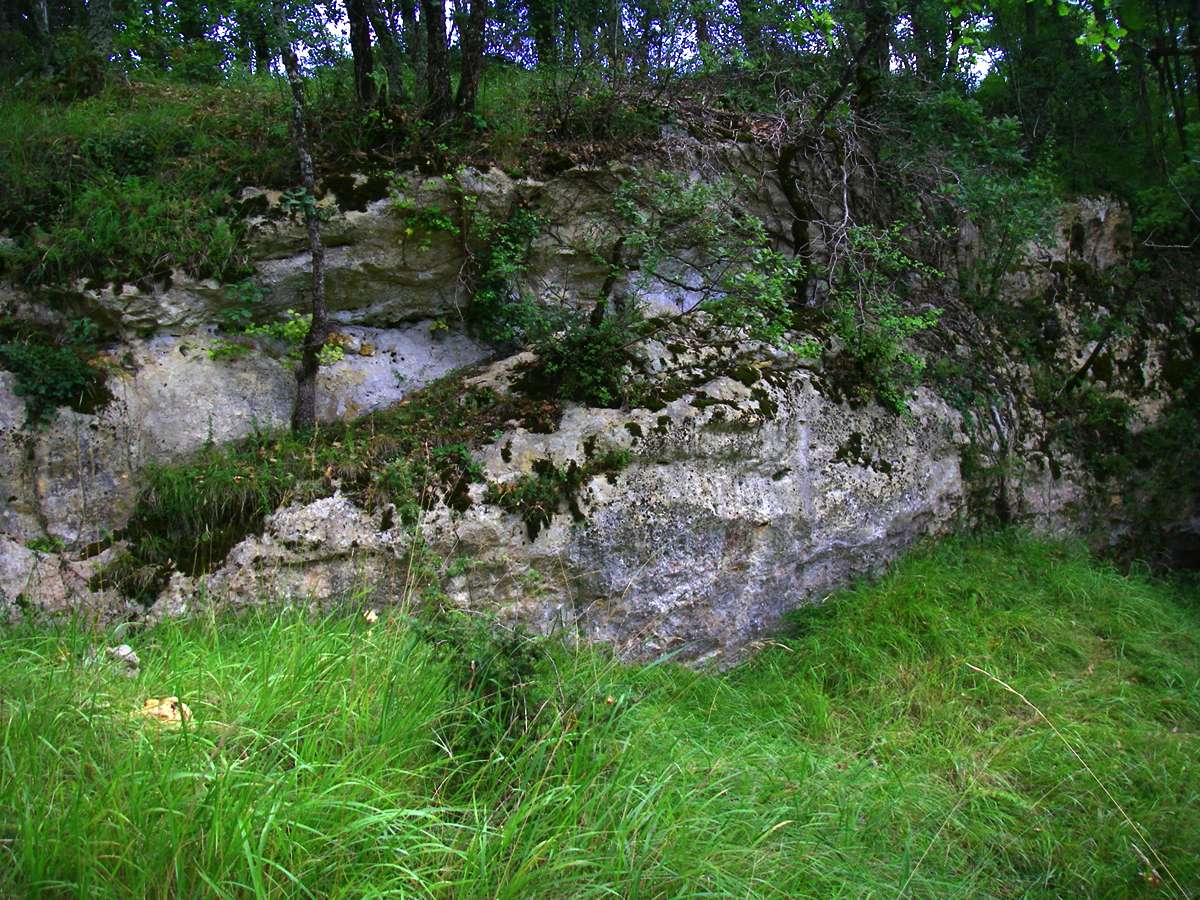
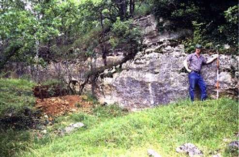
Haut de Combe-Capelle, also known as Abri Peyrony. It is directly upslope from the trench which Ami dug, and at the foot of the cliff below the plateau.
Photo: Don Hitchcock 2008
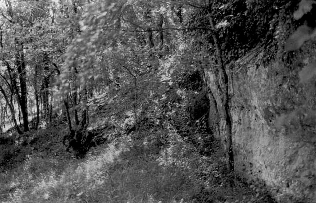
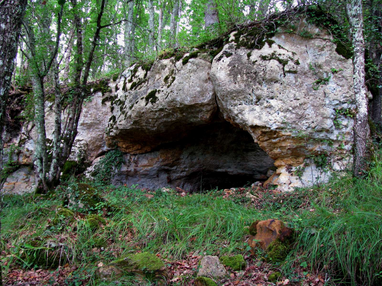
When I looked at my photos I was puzzled that they showed a small cave in the place where the literature showed just a low cliff as being Abri Peyrony, as in the photo on the left.
Finally I realised that in the time since the photographs had been taken (1995 in this case) and 2008 when I was there, a dig had taken place which re-exposed the small cave, which had been covered up by some years of fill being pushed over the edge of the cliff from the quarry above.
The photos are of the same place, as may be seen by the single tree trunk on the right, and the distinctive four trunked tree, somewhat thicker in my photo, on the left, as well as the moss and vegetation spilling down the low cliff beside the cave opening.
Photo: (left) Dibble et al (1995), (right) Don Hitchcock 2008
The Abri Peyrony, or Haut de Combe-Capelle was excavated by Peyrony in 1925. The archaeological deposits, which were not very thick, were situated on two terraces of bedrock. Based both on Peyrony's description and testing carried out in 1990 there appear to be two levels. The upper level is composed of brownish-red sediments which recall the sediments of the plateau immediately above this locale, while the lower level is composed of grayish concreted sediments.
The rich and highly patinated industry recovered by Peyrony (including many of the pieces that he had originally left in his backdirt and which were later recovered by Paul Fitte), is clearly attributable to the Mousterian of Acheulian Tradition, containing numerous small cordiform bifaces, scrapers, denticulates/notches, and Levallois flakes. Our own testing of the site suggests that little remains of the locale, although a significant area immediately adjacent to the cliff has been covered by an enormous amount of debris from the limestone quarry located on the plateau.
Photos and text above: http://www.oldstoneage.com/cc/abri.htm
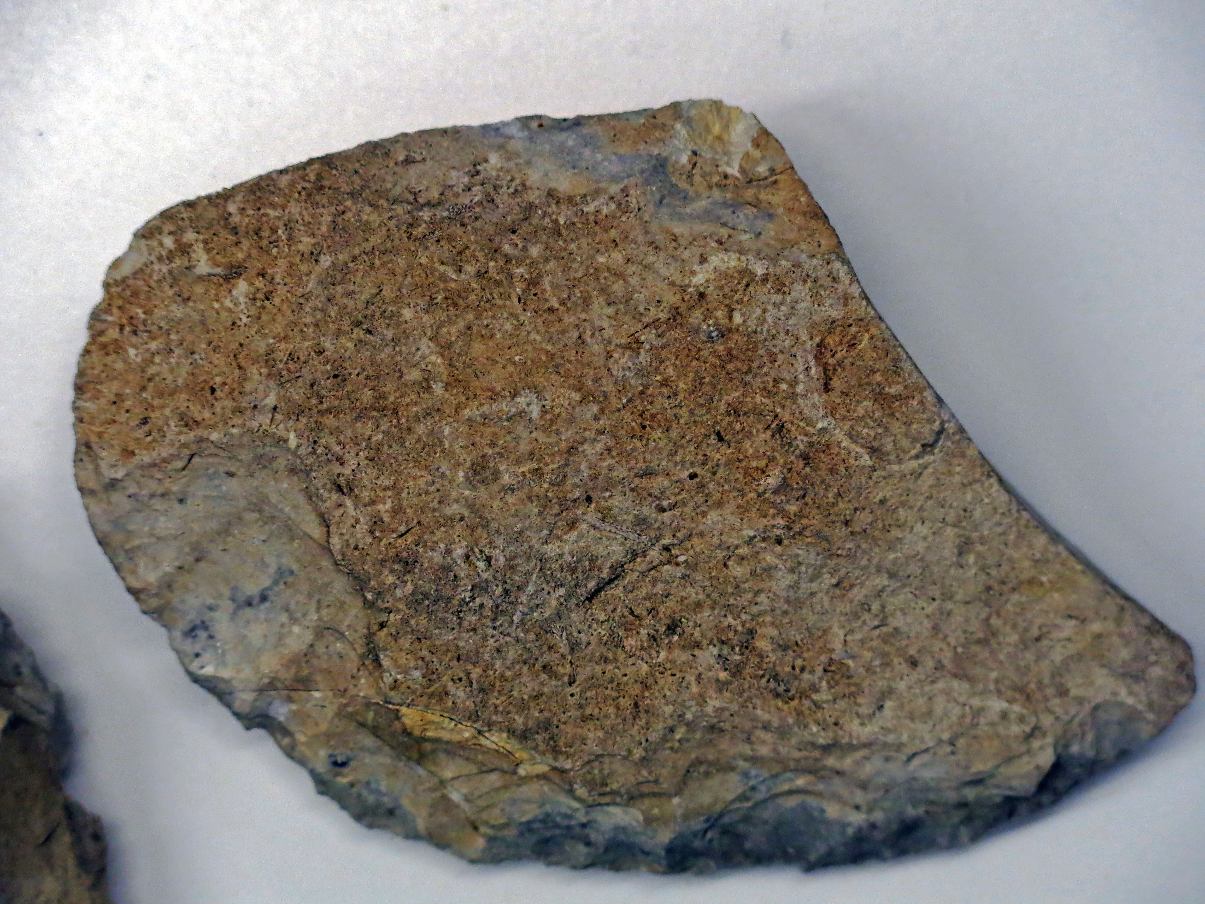
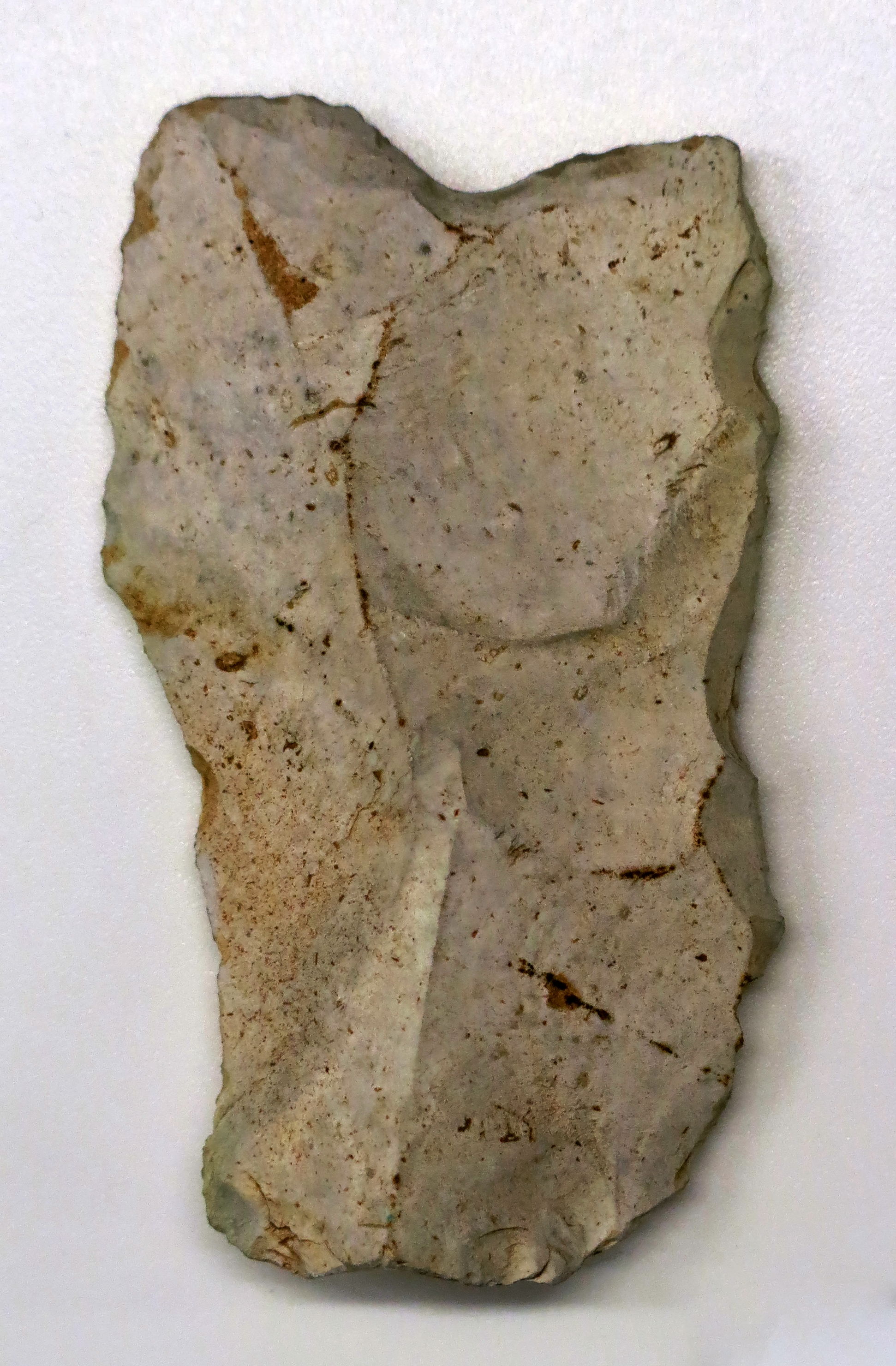
Mousterian racloir, side scraper, from Combe-Capelle, Saint-Avit-Sénieur
Photo: Don Hitchcock 2015
Catalog: 60.380.14
Source: Original, Musée d'Aquitaine à Bordeaux
Mousterian encoche, notched tool, from Combe-Capelle, Saint-Avit-Sénieur.
These were used for shaping materials such as wood, as for example smoothing spear shafts.
Photo: Don Hitchcock 2015
Catalog: 60.382.22
Source: Original, Musée d'Aquitaine à Bordeaux
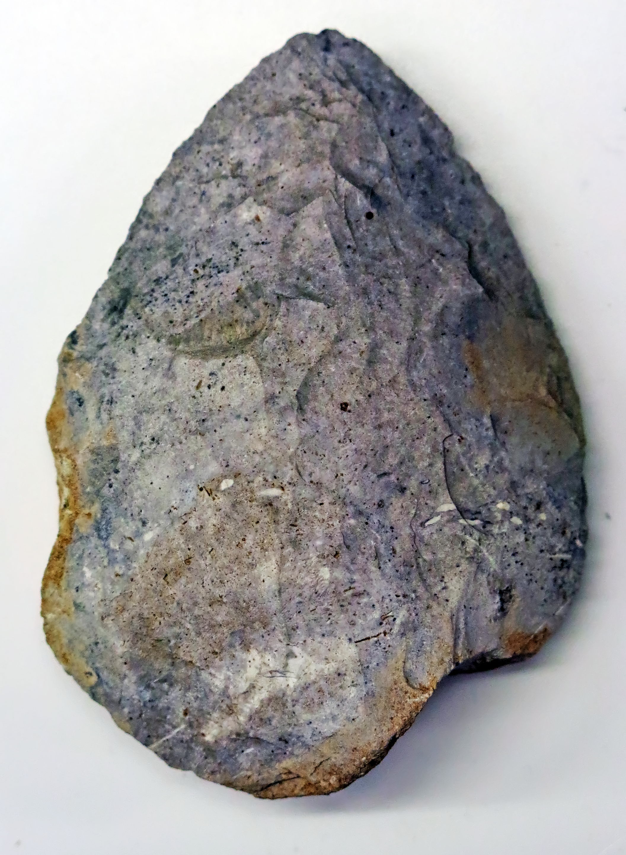
Mousterian biface hand axe, from Combe-Capelle, Saint-Avit-Sénieur.
Photo: Don Hitchcock 2015
Catalog: 60.380.6
Source: Original, Musée d'Aquitaine à Bordeaux
(note that since I was there in 2008 the small cave is once again covered with fill - Don )
The Abri Peyrony (also known as the Haut de Combe-Capelle) was last excavated by D. Peyrony in 1925. It produced a rich Mousterian of Acheulian Tradition (MTA) industry and fauna. At some point prior to 1987, a portion of the site was covered in debris from the nearby quarry in an effort to protect the site. Then in 1990, Lenoir and Dibble did a limited test of the site and were able to locate an archaeological horizon that yielded some stone tools including four bifaces.
The long-term goal is to collect a new, controlled sample of lithics and fauna from the MTA and to date this material. The MTA is quite important as one of the last manifestations of Neadertals in southwest Europe and as perhaps the origins of the Chatelperronian. While it is mostly known from older excavations, more recent excavations at sites like Pech de l'Azé I and IV, Jonzac, and the Bergerac highway sites, are providing new data on the MTA. The new material from the Abri Peyrony will make an additional point of comparison.
Photo and text: http://www.eva.mpg.de/evolution/files/abri_peyrony_combe_capelle.htm
In 2009 we opened a trench against the cliff face and located in situ deposits. In 2010 we excavated these deposits to bedrock. Because the site is quite rich, we were able to generate a large lithic and faunal collection that we are now in the process of studying. Thus far we can confirm the presence of MTA only on the lower terrace. The upper terrace industry in clearly Middle Paleolithic, with Levallois and discoidal techniques of blank production, but there are no handaxes or backed pieces. Geological, site formation, dating, faunal, and lithic studies are underway. Whether there are renewed excavations at the site depends on the results of the on-going studies.
The Roc de Combe-Capelle is located about 60m from the Abri Peyrony along the same cliff line. The site became famous in 1909 when Hauser discovered a nearly complete skeleton of Homo sapiens, which Hauser and later others thought was associated with the Chatelperronian at the base of the sequence. Above the Chatelperronian the site also contained Aurignacian, Gravettian and Solutrean. Our excavations in 2009 at this site confirmed that nothing remains of this sequence today and that the site has been entirely excavated (what remains is only backdirt). It is still possible that some smalll, isolated pockets of in situ material remain in places under the backdirt or against the cliff, but we have no additional plans to work at the site.
Photo and text: http://www.eva.mpg.de/evolution/files/abri_peyrony_combe_capelle.htm
Oldest Specialised Bone Tools Ever Found in Europe
Context of Discovery and Radiometric Age
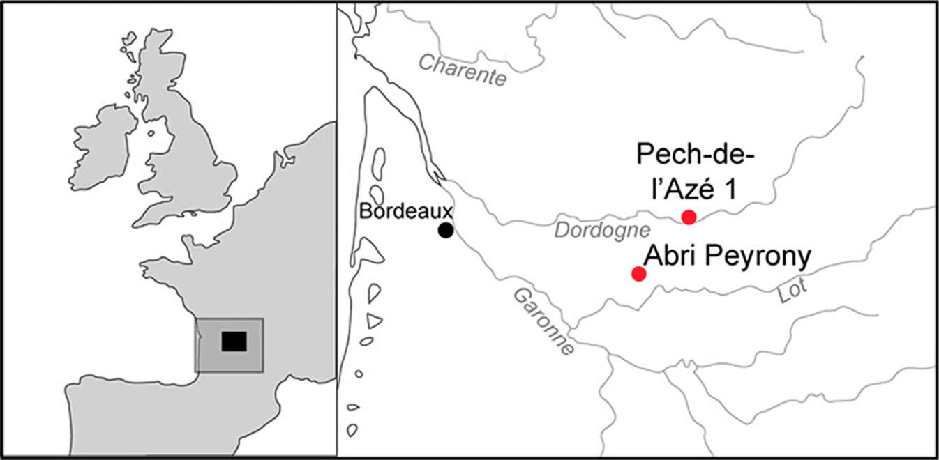
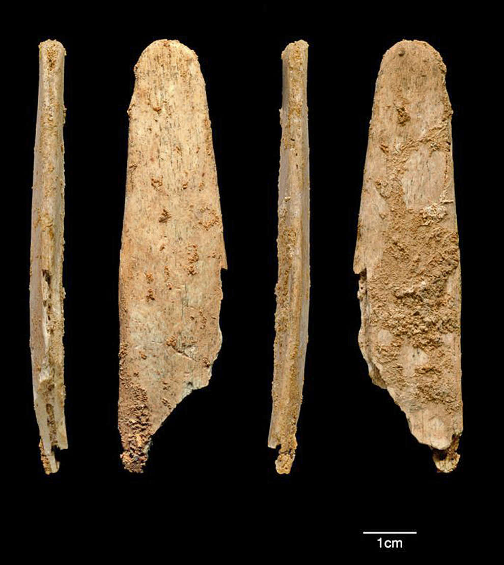
Two recently excavated Mousterian of Acheulian Tradition (MTA) sites, Pech-de-l’Azé I (Pech I) and Abri Peyrony, located ∼35 km from each other on separate tributaries of the Dordogne river in southwest France yielded nearly identical fragments of bone with smoothed edges and a rounded tip. The three Abri Peyrony bones were recovered from two levels (3A and 3B) within layer L-3. This layer is composed of limestone fragments and detritus derived from the backing cliff, and it rests on the bedrock. The layer was cemented during or shortly after deposition by calcium carbonate from a groundwater seep at the base of the cliffline. This cementation prevented postdepositional disturbance (e.g., bioturbation) from affecting the deposit, and an intact combustion feature in level L-3A demonstrates minimal postdepositional disturbance. The lithics from level L-3A include handaxe thinning flakes, cordiform handaxes, and backed knives typical of the MTA. The level L-3B lithics are very similar with regard to blank excavations. Seven 14C accelerator mass spectrometry age determinations on cut-marked bone from layer 3 provide a range of 47 710 - 41 130 Cal B.P.
Photo and text: Soressi et al (2013)
MTA definition:
The Mode 2 Acheulean toolmakers prized the core rather than the flakes that came from it, and were worked symmetrically and on both sides indicating greater care in the production of the final tool. Mode 3 technology emerged towards the end of Acheulean dominance and involved the Levallois technique, most famously exploited by the Mousterian industry. Transitional tool forms between the two are called Mousterian of Acheulean Tradition, or MTA types. (text adapted from Wikipedia)
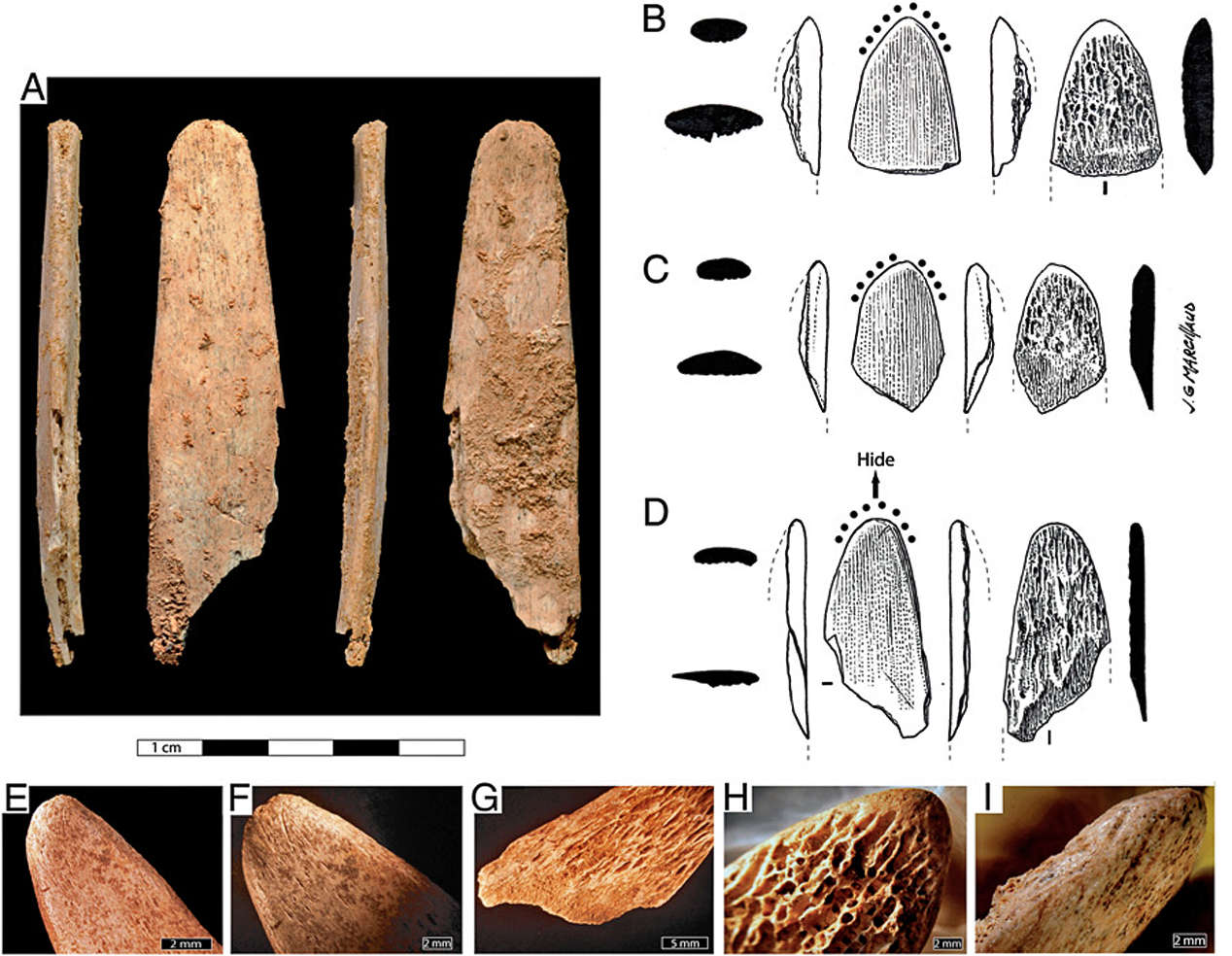
Photographs and drawings of the Abri Peyrony (AP) and Pech-de-l’Azé I (PA I) bone tools. (A) AP-7839. (B) AP-4209. (C) AP-4493. (D) PA I G8-1417.
(E and F) G8-1417 cortical side showing a uniform shine, rounding and slight crushing of the distal end. (G) G8-1417 trabecular bone with no rounding or
striations and a bending fracture. (H) Close-up of tip polish on AP-4209 showing gradient from cortical bone to polished trabecular bone to fresh trabecular
bone. (I) Close-up of facet on AP-4209.
The Pech I bone, G8-1417, comes from layer 4 at the base of the sequence. Layer 4 consists of stone artifacts, bones, including one juvenile Neandertal tooth, and ash (from hearths) in a clayey, sand matrix. These sands, deposited by run-off, are derived from underlying endokarstic fluvial sediments. Minimal postdepositional disturbance is indicated by anatomical connections of a number of bones, spatial association of burned bone with ashes, artifacts broken in situ by rock fall, and a low percentage (< 1%) of trampling fractures on bone. Bone preservation is good, with only 30% (number of specimens > 2.5 cm = 2 632) affected by surface weathering and less than 8% being rounded. There is little evidence of carnivore impact on the assemblage, and carnivores seem to have had a very limited role in the assemblage formation.
The stone artifacts include cordiform handaxes and backed knives typical of the MTA. No Upper Paleolithic or later period deposits have been found during four different excavations, and layer 4 is below 3 metres of undisturbed Middle Paleolithic deposits. Single-grain optically stimulated luminescence dating of three sediment samples from layer 4 gave a weighted mean age of 51 400 ±2 000 BP. This age is consistent with previously reported conventional radiocarbon, electron-spin resonance, and coupled electron-spin resonance/uranium-series ages.
Photo and text: Soressi et al (2013)
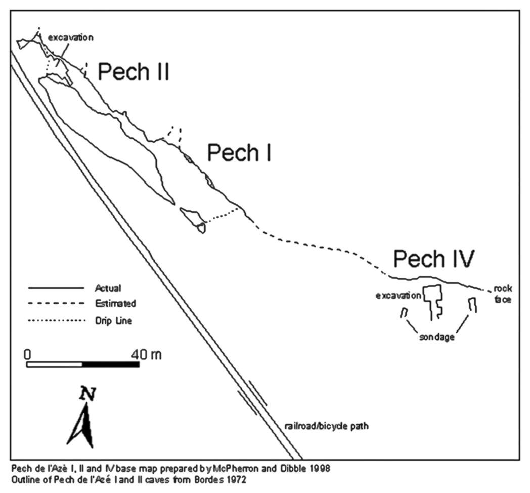
(Left) Location of Pech de l'Azé. This map shows the location of Pech in relation to modern towns and several other prehistoric sites.
(Right) Pech de l’Azé (pronounced 'pesh/de/lahz' as if the final accent was not present) is a cluster of four Lower and Middle Paleolithic sites. They are situated some 50 metres off the floor of a small, usually dry, valley that runs into the Enéa, a small tributary of the Dordogne River. Pech de l’Azé I and II are at opposite entrances of a single tunnel-like cave that intersects a promontory in the limestone cliff.
Pech de l’Azé IV is a collapsed rock shelter roughly 80 metres east from the mouth of Pech I. Pech de l’Azé III (not shown in the figure) is a small cave in the same cliff located about 30 metres west of the opening of Pech II.
Pech de l'Azé I, II, and IV base map prepared by McPherron and Dibble 1998. Outline of Pech de l'Azé I and II caves from Bordes 1972. This map of the Pech sites was made in 1998. What was a railroad track running in front of Pech I and II is now a bicycle path.
Photo and text: http://www.oldstoneage.com/pechiv/maps.shtml
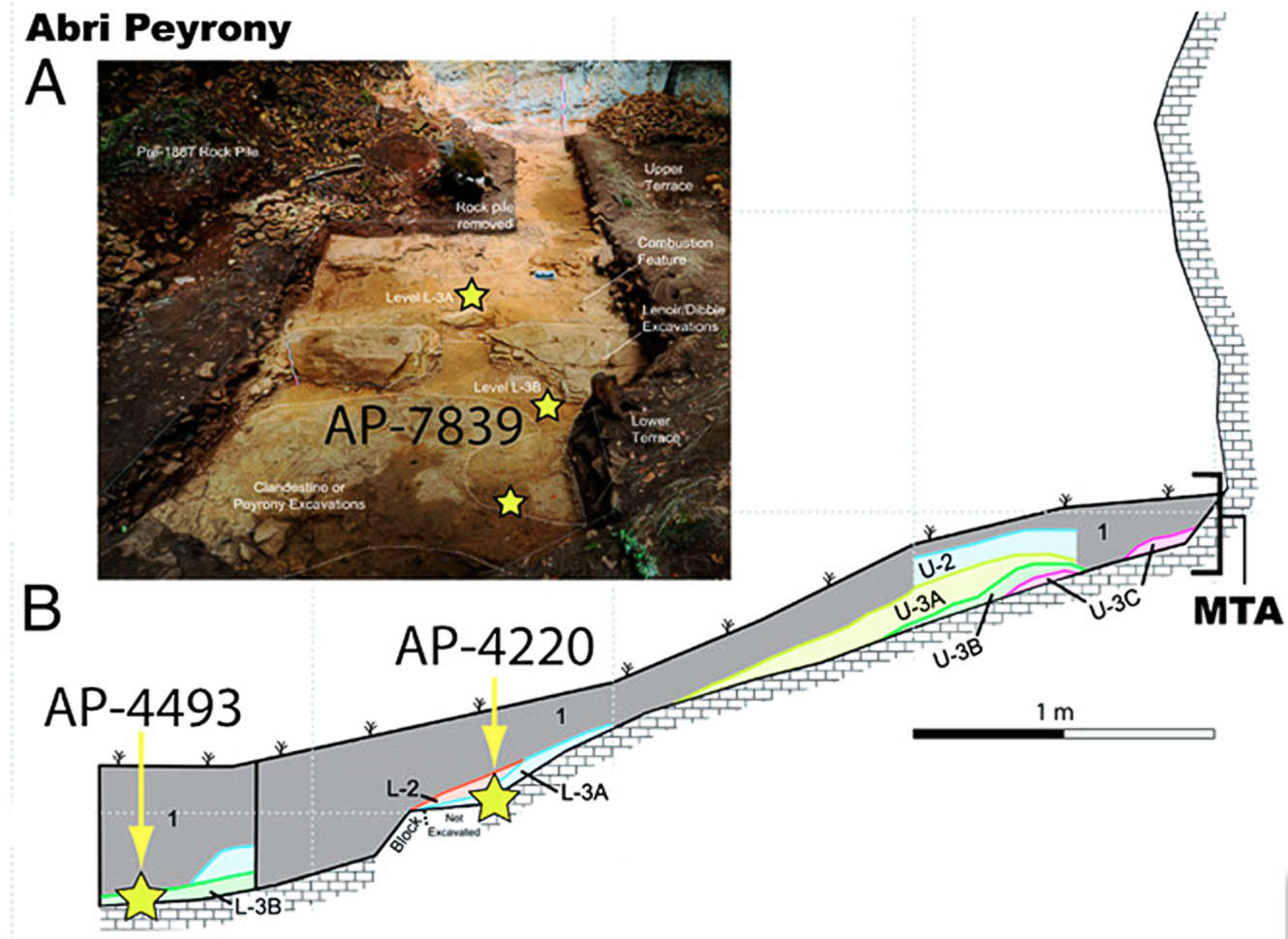
Abri Peyrony
(A) View north of Abri Peyrony after 2010 excavation.
(B) East section of Abri Peyrony with stars indicating the levels containing the reported bones.
Photo and text: Soressi et al (2013)

Pech de l'Azé.
(C) View of the Pech I 3-m MTA section.
(D) East section of Pech I with the star indicating the location (1metre from the drawn section) of the reported bone.
Photo and text: Soressi et al (2013)
General Discussion of the finds
Archaeologists have unearthed the oldest specialised bone tools ever found in Europe, at sites where Neanderthals lived more than 40 000 years ago.
The slender, curved implements called 'lissoirs' were shaped from deer ribs and likely used to work animal hides to make them softer, tougher and more waterproof. The tools are remarkable because they seem to pre-date the arrival of modern humans in Europe, suggesting that Neanderthals invented them, rather than copying the designs from humans.
Similar tools, called slickers or burnishers, are still in use by leather workers today, meaning the instruments may be the only known examples of modern tools that owe their existence to our ancient Neanderthal relatives.
'There's a good case to be made for Neanderthals inventing this one aspect of modern human technology,' said Shannon McPherron at the Max Planck Institute for Evolutionary Anthropology in Leipzig. 'It's the first time we've seen Neanderthals use bone in a way that uses its unique properties.'
The tools are said to be 'specialised' because they exploit particular features of bone, such as its toughness and flexibility. Lissoirs could not be made from a hard and brittle material like stone, because it would damage the leather and risk snapping in the user's hand. But made from bone, the tool would flex as it was pressed onto a hide.
Researchers led by Marie Soressi at Leiden University found the first large piece of a lissoir at a cave called Pech-de-l'Azé I on a tributary of the Dordogne in southwest France. The skull of a Neanderthal child, ash from a hearth and other Neanderthal remains were found at the same site, but there is no sign that Cro-Magnons, modern humans, ever lived there. The site dates to around 51 000 years ago.
Photo: http://www.heise.de/tp/artikel/39/39696/1.html
Text: http://www.theguardian.com/science/2013/aug/12/neanderthals-invented-tool-leather-lissoir
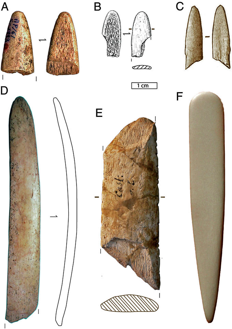
Examples of Upper Paleolithic lissoirs.
A Distal fragment of a Gravettian lissoir from Abri Pataud (France) (45)
B Distal fragment of a Proto-Aurignacian lissoir from La Grotte du Renne (France) (42)
C Magdalenian lissoir from La Grotte de la Vache (France) (24)
D Almost complete Aurignacian lissoir from Gatzarria (France)
E Mesial fragment (with typical scars of bending fractures at both ends) of an Aurignacian lissoir from Castanet-Nord (France) (46)
F An unused modern lissoir (upper end) and plior (bottom end) used by leather craftsmen and made from a cow rib, purchased from the Internet, January 2013
[(A) Collection MNHN, photo by C. Vercoutère; (C) Photo by E. Tartar; (D) Castanet project archives.]
Photo and text: Soressi et al (2013)
Excavation in Abri Peyrony, at Combe Capelle in the French Dordogne, where recently three special bone tools, Lissoirs, for leather processing, were excavated .
The group led by McPherron, unearthed three smaller tips of lissoirs at another Neanderthal site 35km away, beneath a shallow cliff face in Abri Peyrony, part of Combe Capelle, a well known Neanderthal site. Carbon dating revealed that bone at the site was 41 000 to 48 000 years old.
The tools were probably made from the ribs of red deer or reindeer, the authors write in Proceedings of the National Academy of Sciences. The tip of each tool was tapered, ground and rounded off, and one side was polished to a shine. The other side was fresh, unmodified bone. Intact, each tool would have been 20 to 40cm long, Soressi said.
Under the microscope, the tip of the largest tool, around 8cm long, showed signs of wear from being used. The scientists saw similar abrasive marks when they made copies of the tools from fresh animal ribs and used them to smooth out a dry hide. The smaller tips likely broke off when the Neanderthals pressed too hard.
Other bone tools made by Neanderthals have been found before, but the lissoirs are thought to be the first that required a technological leap to exploit the special properties of bone.
'They were taking a rib and probably snapping or grinding the end off it, then grinding the tip into a smooth arch shape. They were then pushing the tip into a hide, and that process of applying firm pressure across the hide makes the leather more pliable and more water resistant. They didn't choose any old bone, they chose ribs which have some give to them. The rib flexes in your hand and doesn't gouge the leather, it polishes it,' said McPherron.
The scientists put forward several scenarios to explain the origins of the tools. Fossil evidence suggests that the first wave of modern humans reached Europe with stone and bone tools around 43 000 years ago. But perhaps they arrived much earlier, and Neanderthals learned bone tool skills from them. Another possibility is that the technology spread to Neanderthals in Europe from modern humans who were already in the Middle East. A third is that Neanderthals invented the tools and early modern humans adopted them when they arrived.
Soressi discovered the larger lissoir in 2005, but had to wait for more fragments to be found before she could convince a journal to publish the work. 'Neanderthals were able to produce these tools and they have so perfect a design that we are still using them today. What surprises me is to have something that lasts 50 000 years with almost no changes. It's so well adapted to the task,' she said.
'This adds to the evidence that Neanderthals were developing their own complexity culturally and brings us back to the question of whether they were doing this on their own, entirely independently, or under the influence of modern humans,' said Chris Stringer, head of human origins at the Natural History Museum in London.
'It looks like there weren't modern humans alongside the Neanderthals passing this kind of technology across. But modern humans had made it to the Middle East at this time, and they bred with Neanderthals there, so maybe there could have been exchanges of information that then spread westwards,' he said.
Stringer concedes that the Neanderthals might have invented the tools themselves. 'They had big brains, complex societies and were skilful toolmakers. They survived under difficult conditions for long periods. The whole image of the Neanderthals being the grunting cavemen is out of the window, and for me has never been an accurate portrayal. They were not stupid.'
Photo: Abri Peyrony / Pech-de-l'Azé I Projects, http://www.heise.de/tp/bild/39/39696/39696_1.html
Text: http://www.theguardian.com/science/2013/aug/12/neanderthals-invented-tool-leather-lissoir
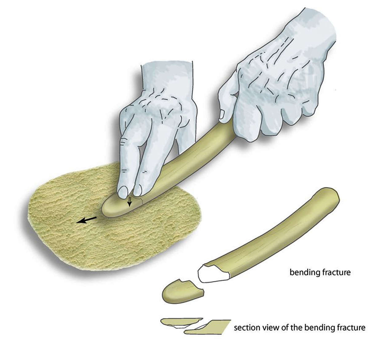
Diagram of the use of the Lissoirs, made from the ribs of deer, which were used to make animal skins supple, shiny and water resistant. The natural flexibility of the ribs ensures a constant pressure on the animal skin, but without tearing. The lower part of the figure shows how the downward pressure eventually leads to breakage, by which small fragments - like the three found - arise.
Photo: Abri Peyrony / Pech-de-l'Azé I Projects, http://www.heise.de/tp/bild/39/39696/39696_1.html
Text: http://www.heise.de/tp/bild/39/39696/39696_1.html
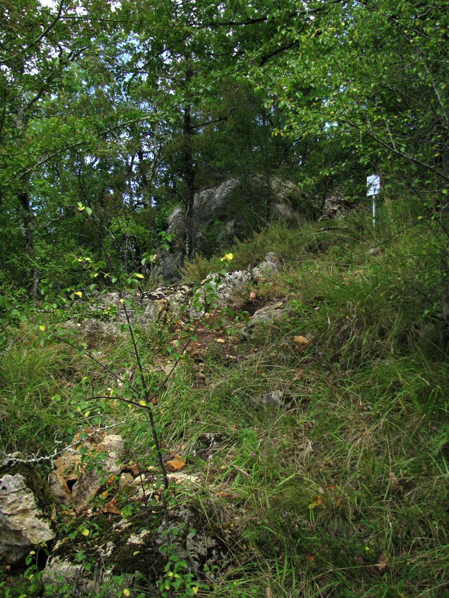
Roc de Combe-Capelle, viewed from down-slope.
Photo: Don Hitchcock 2008
Roc de Combe-Capelle
Photo: Don Hitchcock 2008

Close by Roc de Combe-Capelle.
This was pointed out to me by the official from the French Ministry of Culture as illegal digging by flint tool collectors. This is a continuing problem at many similar sites.
Photo: Don Hitchcock 2008

Roc de Combe-Capelle.
Photo: Don Hitchcock 2008
Roc de Combe-Capelle
This photo is taken from a viewpoint a few metres to the right of my photo. (Note the distinctive white mark on the rock.) It would appear that there has been about 50 cm of material built up at the foot of the rock between the times of the two photos.
There is a quarry on the plateau a few metres above this section, and Dibble et al (1995) refer to a large amount of quarried limestone rubble being dumped over the cliff directly onto the vicinity of the site.
Photo: http://www.oldstoneage.com/cc/rocdecc.htm
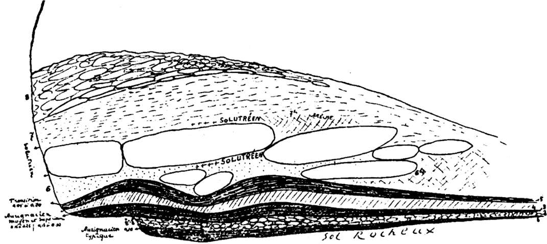
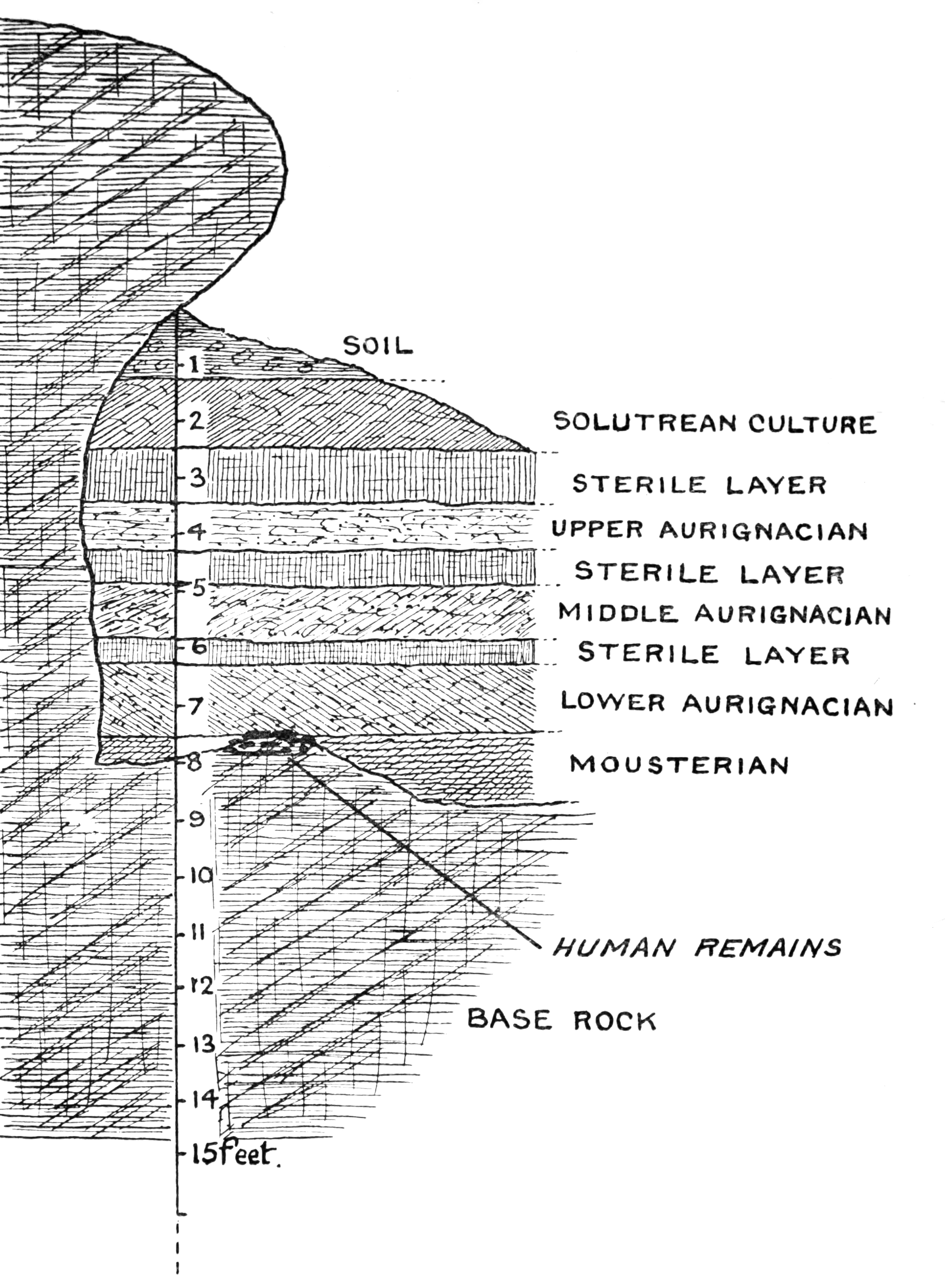
Coupe stratigraphique du gisement de Combe-Capelle fait le 01.07.1907, d'apres H. Breuil.
This is almost certainly the stratigraphy of the Roc de Combe Capelle at the top of the slope, originally excavated by Villeréal in 1907.
Photo: Breuil (1909) in Groenen (1994)

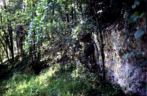
Looking down the slope of Combe-Capelle from Roc de Combe-Capelle
Photo: Don Hitchcock 2008
Looking down the slope of Combe-Capelle from the top of the Ami trench.
Photo: Don Hitchcock 2008
Map of the dig at Combe-Capelle
Photo: Dibble et al (1995)

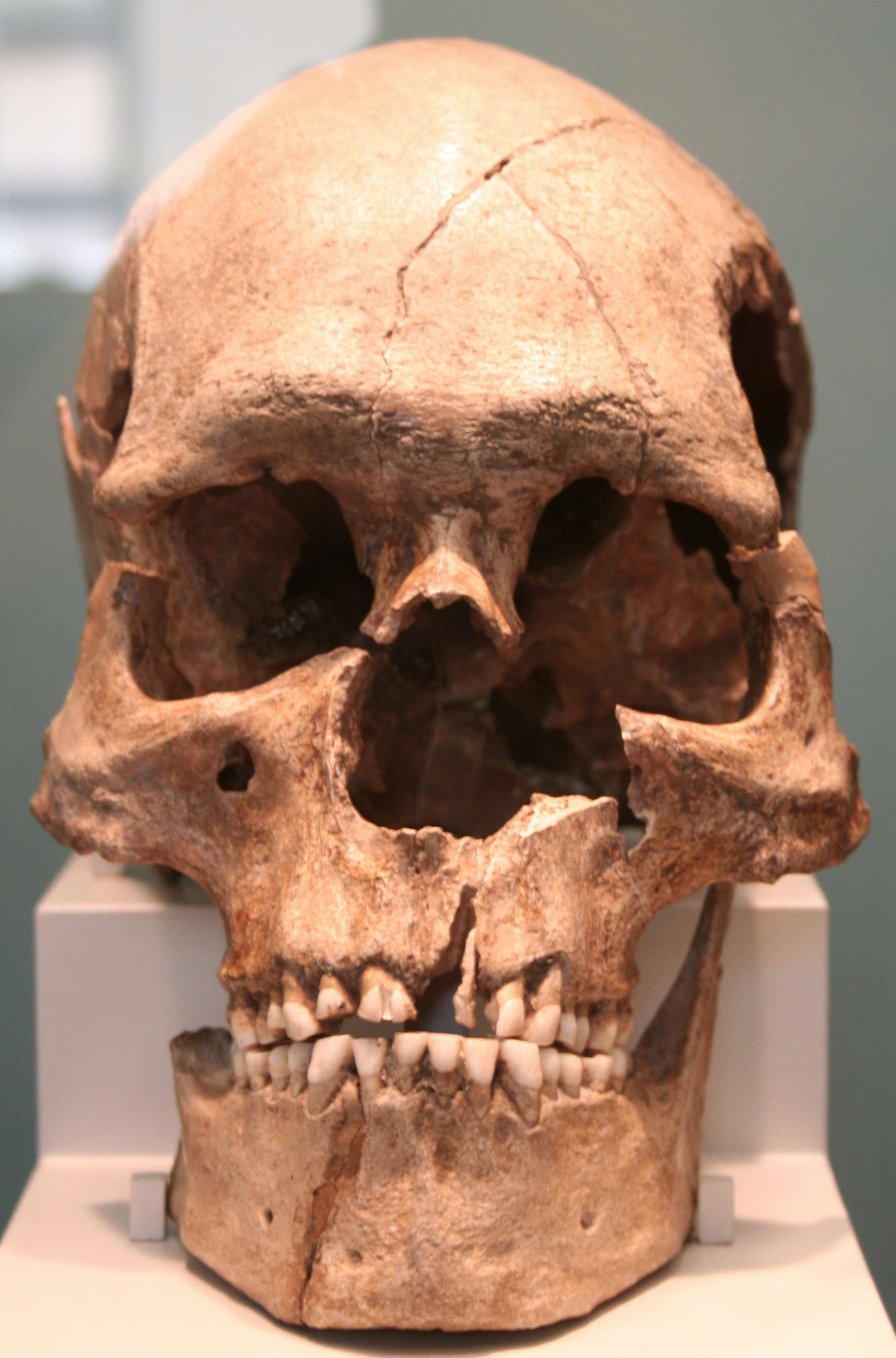
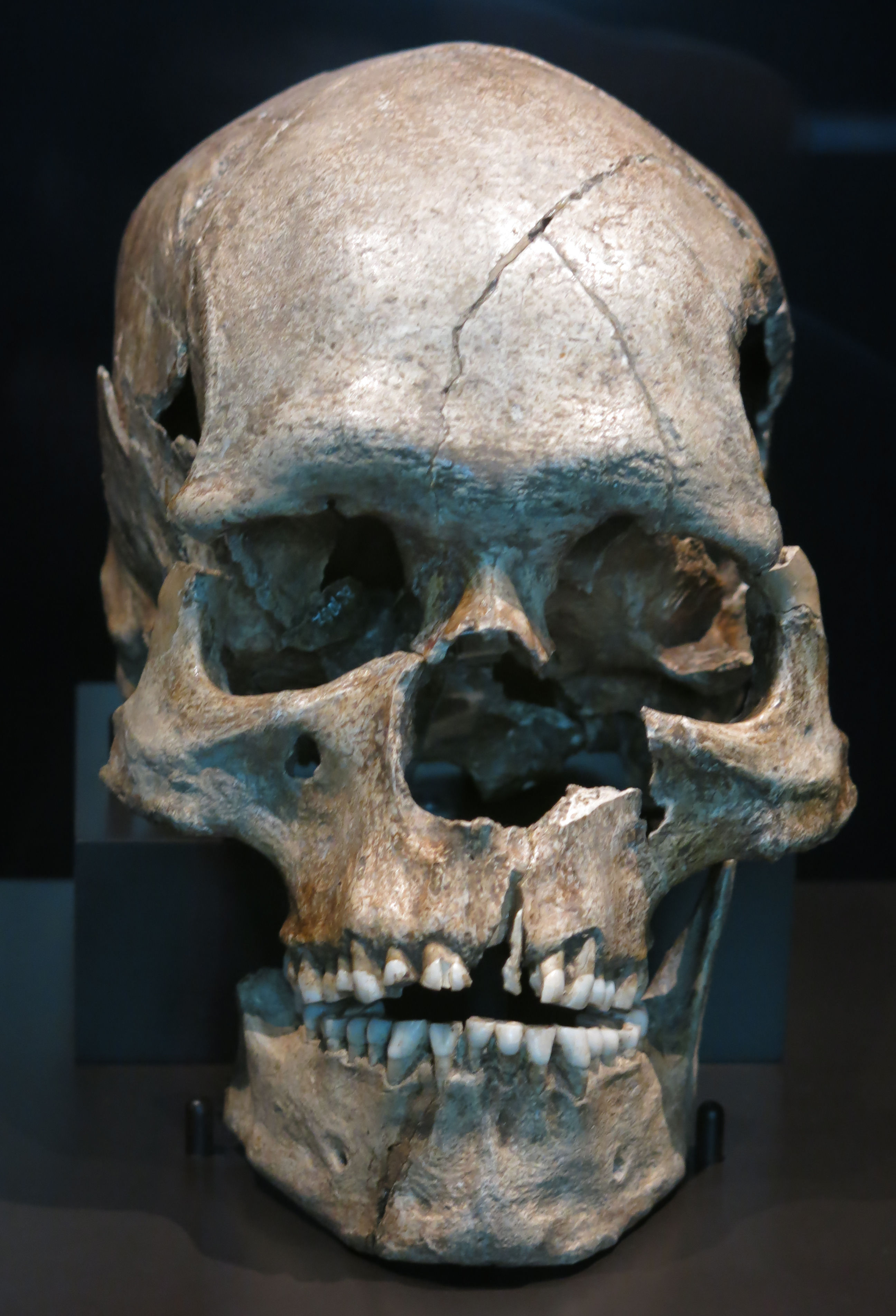
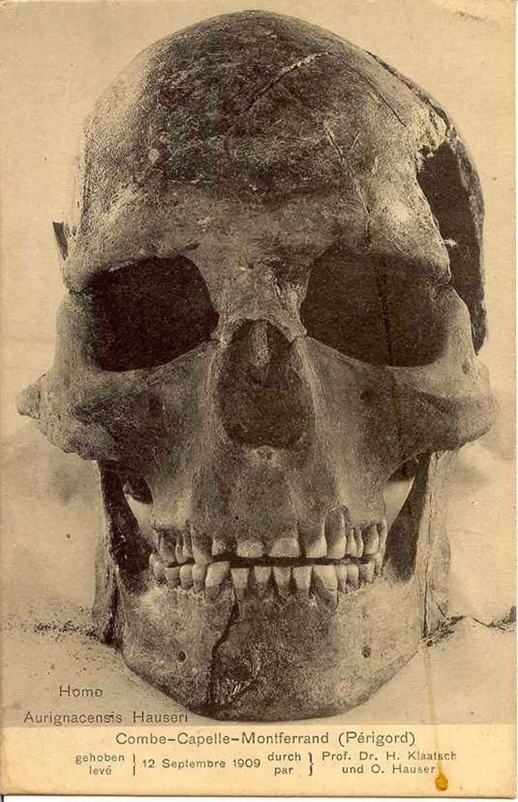
Combe-Capelle skull
Photo: Wikipedia
Provenance:
Deutsch: Schädel des fossilen Homo sapiens sapiens aus dem Aurignacien von Combe Capelle
English: skull of the fossil Homo sapiens sapiens from the Aurignacien of Combe Capelle
Date: 28 August 2008
photographed by Dr. Günter Bechly
The fossil skull is displayed since 2003 in the Museum für Ur- und Frühgeschichte in Berlin - Charlottenburg (Germany).
(Note: This may be the original, or a good facsimile from the original, which was rediscovered in 1990 after having been thought to be lost forever in the fires during the final assault of Russian troops on Berlin in 1945. See the abstract below from Henry-Gambier and White (2003) - Don )
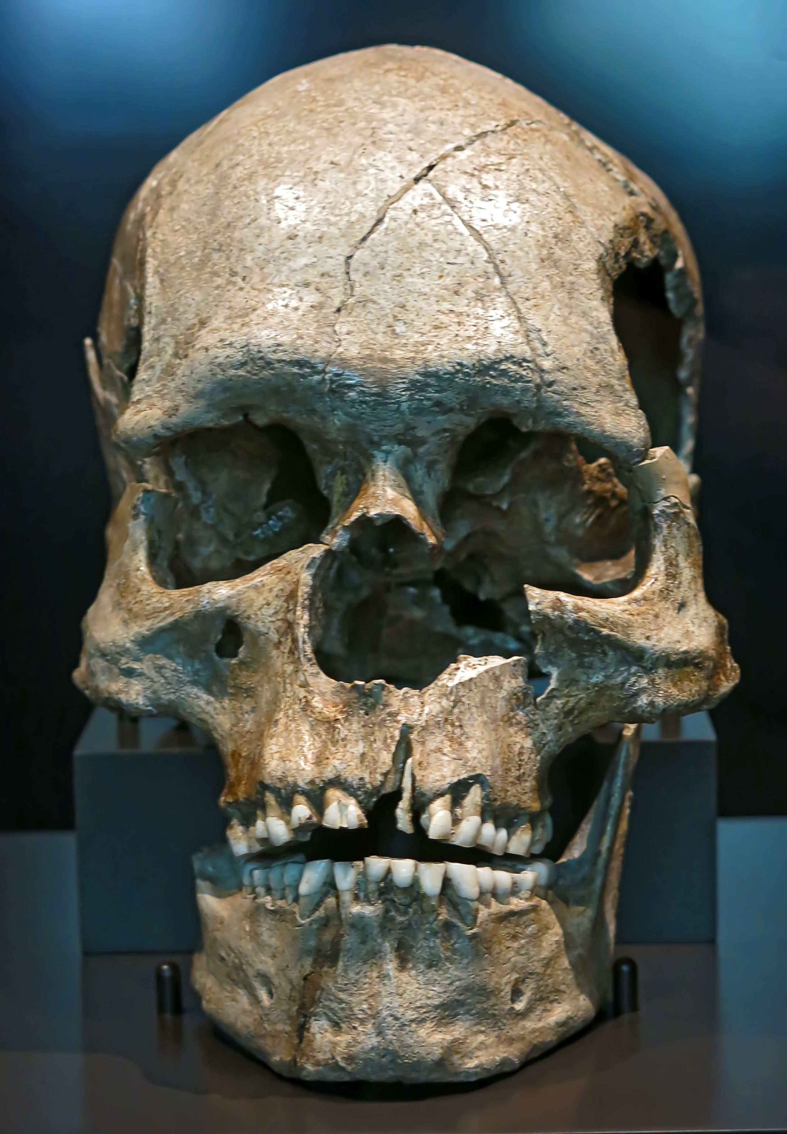
Combe-Capelle skull, another version.
Photo: Einsamer Schütze, Lone Shooter
Permission: GNU Free Documentation License, Version 1.2 or any later version
Date: 2011.06.28
Source: Museum für Vor- und Frühgeschichte, Berlin.
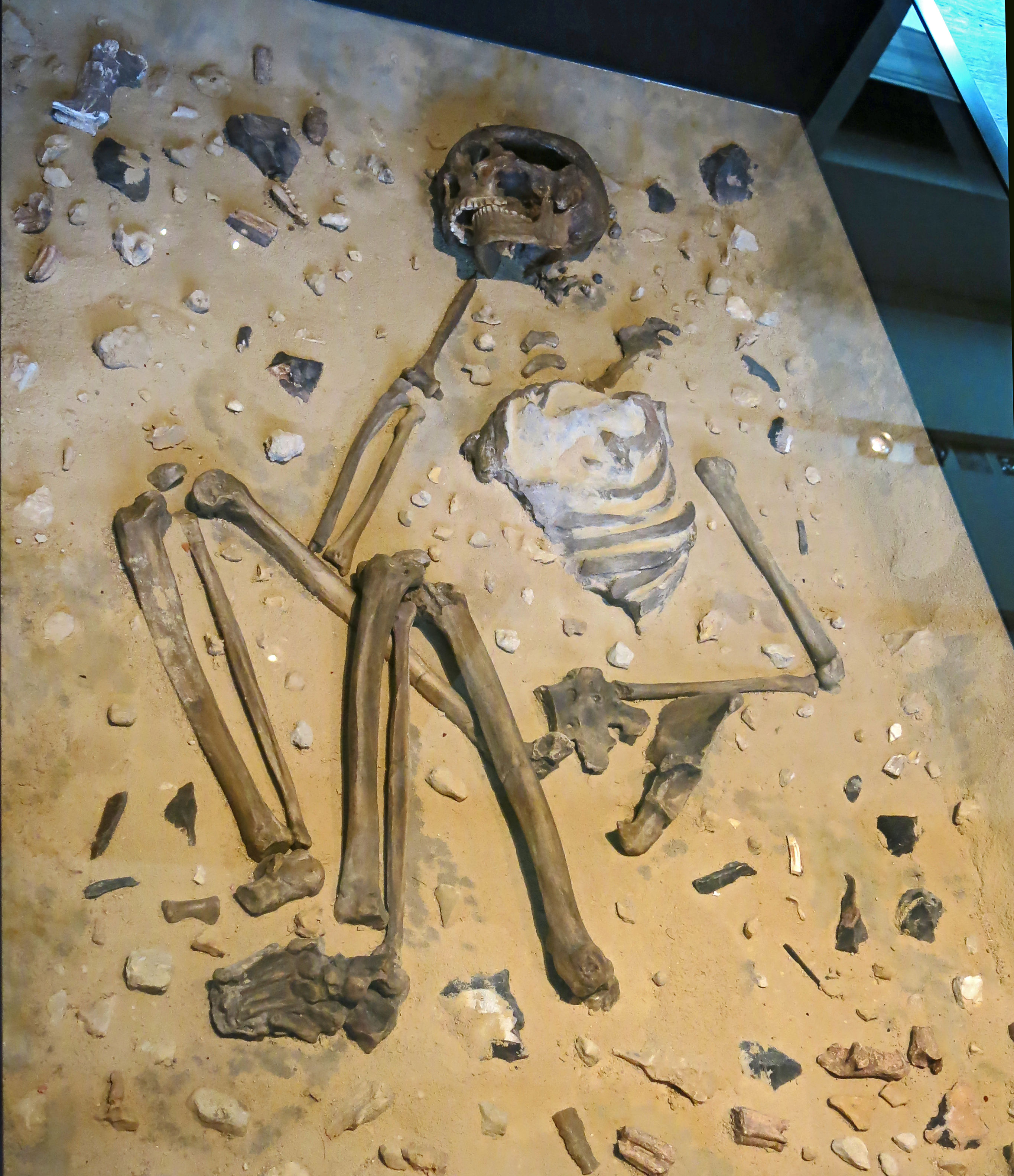
Reconstruction of the burial at Combe Capelle of 'Homo Aurignaciensis Hauseri' with grave goods, circa 9 600 BP.
Photo: Don Hitchcock 2015
Source and text: Facsimile, Staatliche Museen zu Berlin, Neues Museum, Germany
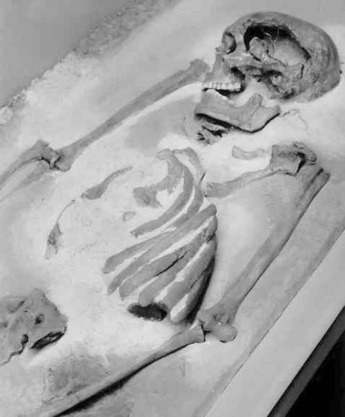
The strata at the rock shelter of Combe Capelle, showing the position of the human skeleton discovered by Herr Hauser.
Photo: Keith (1915)
Proximal source: archive.org


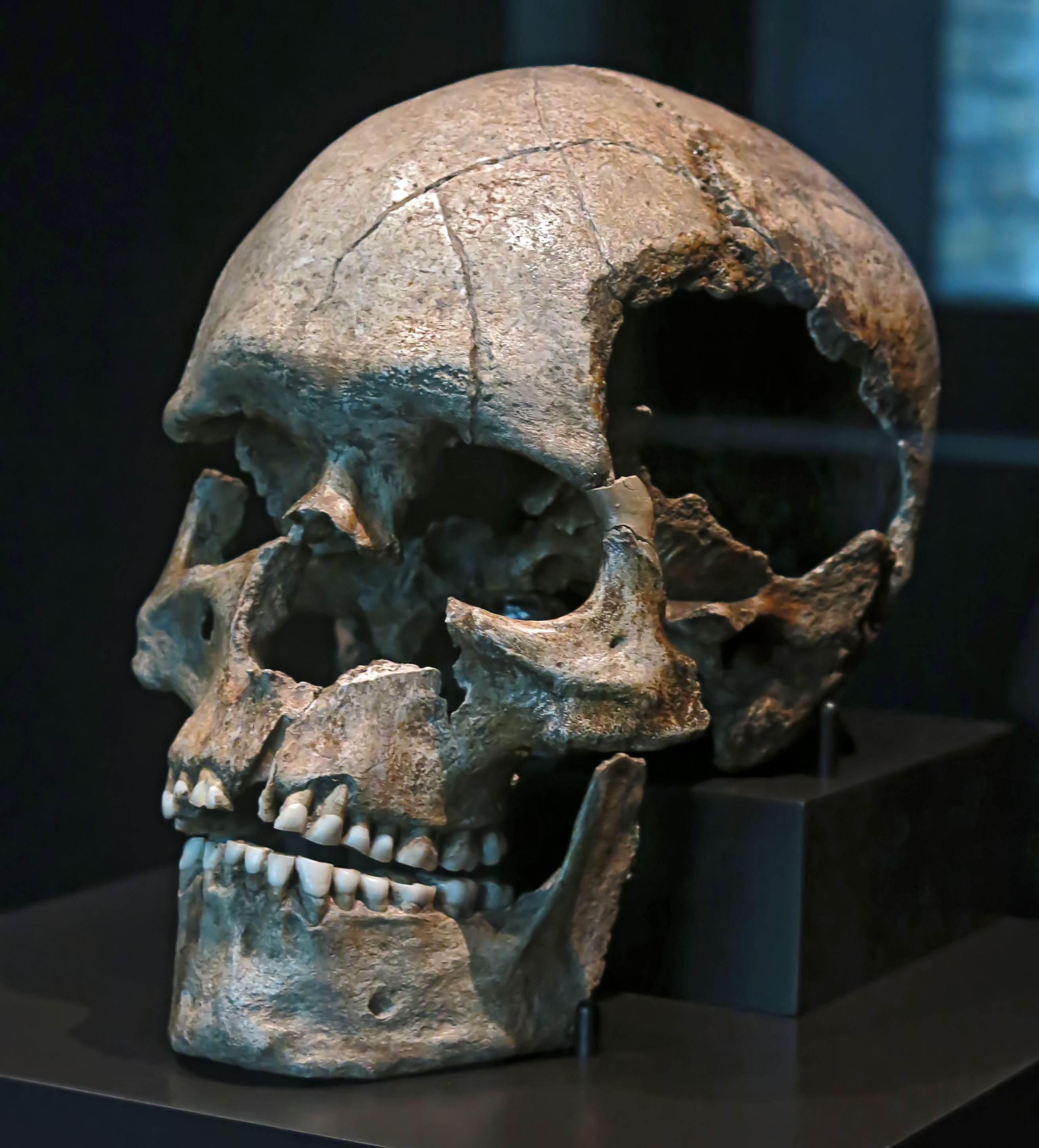
Homo Aurignaciensis Hauseri was a modern human, Homo sapiens sapiens.
Photo: Don Hitchcock 2015
Source: Staatliche Museen zu Berlin, Neues Museum, Germany

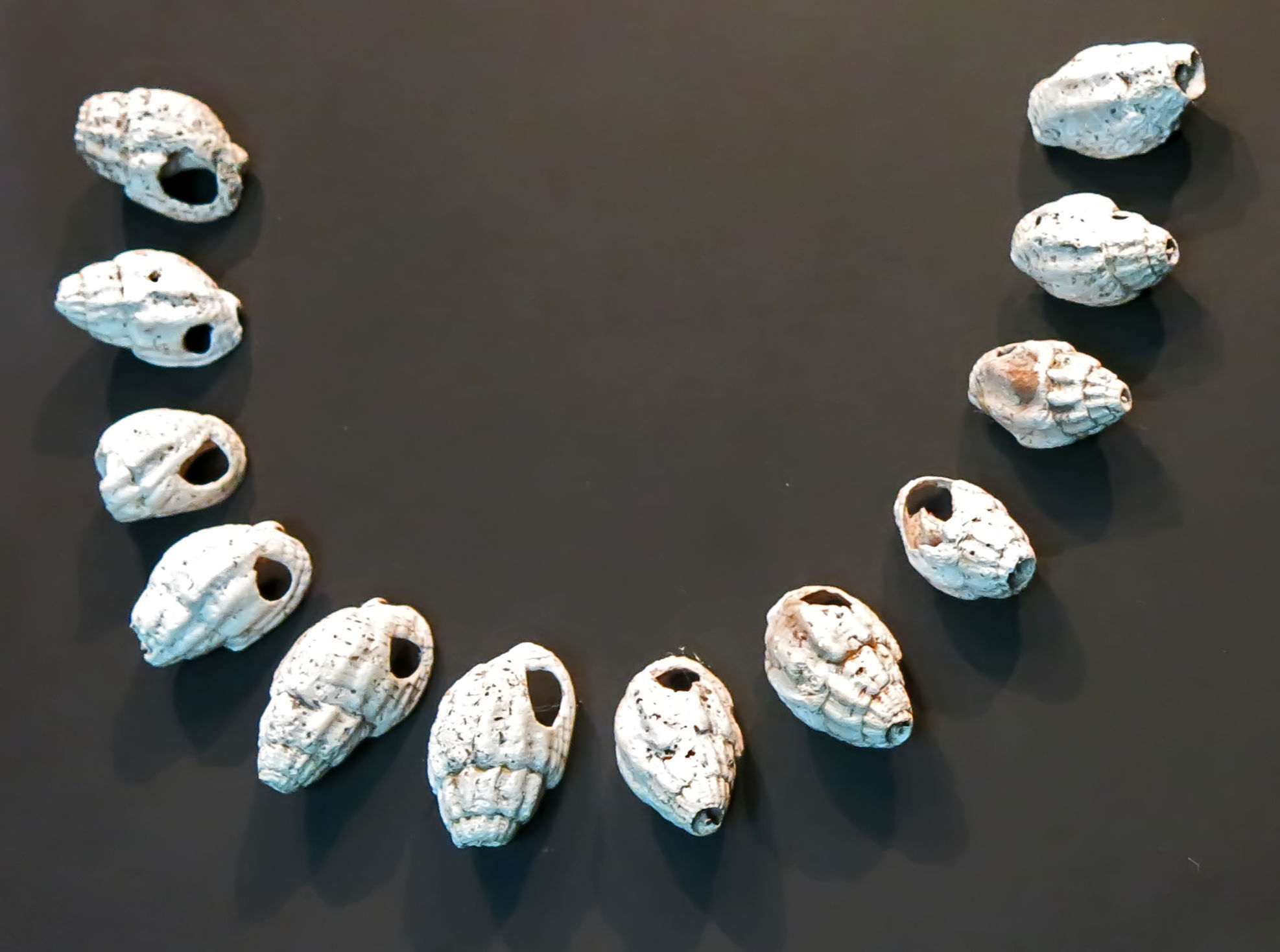
Homo Aurignaciensis Hauseri
The drilled shells were for personal adornment.
Photo: Don Hitchcock 2015
Source: Staatliche Museen zu Berlin, Neues Museum, Germany
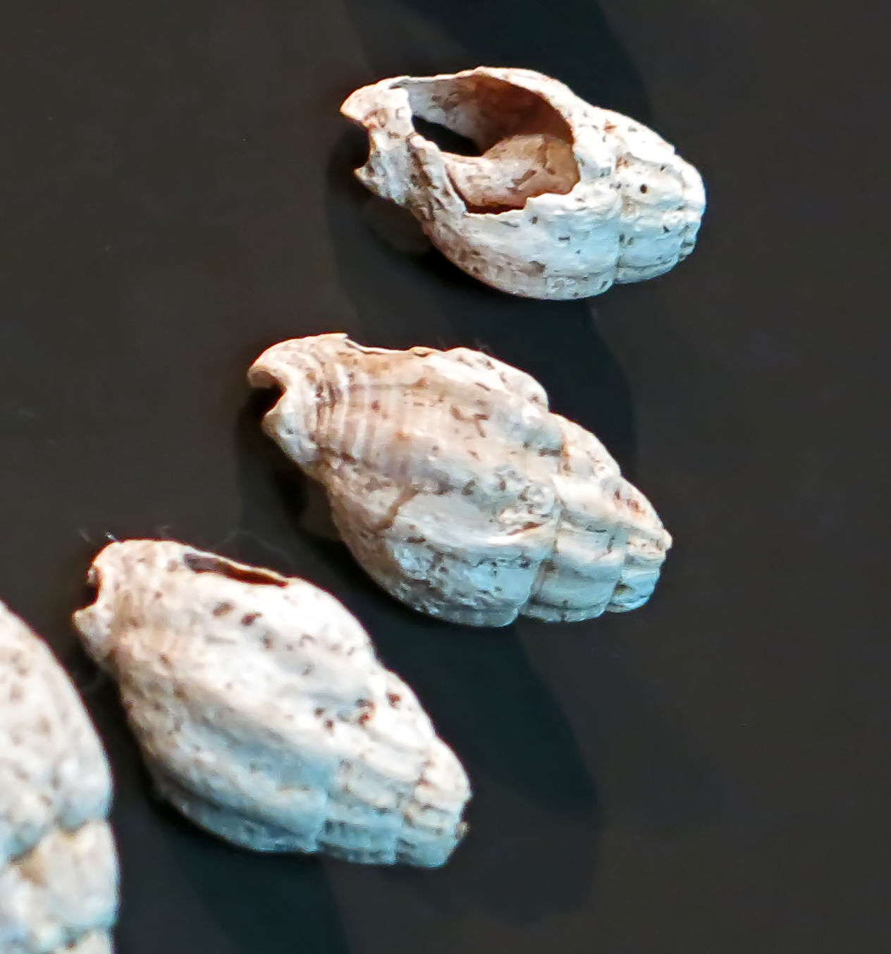
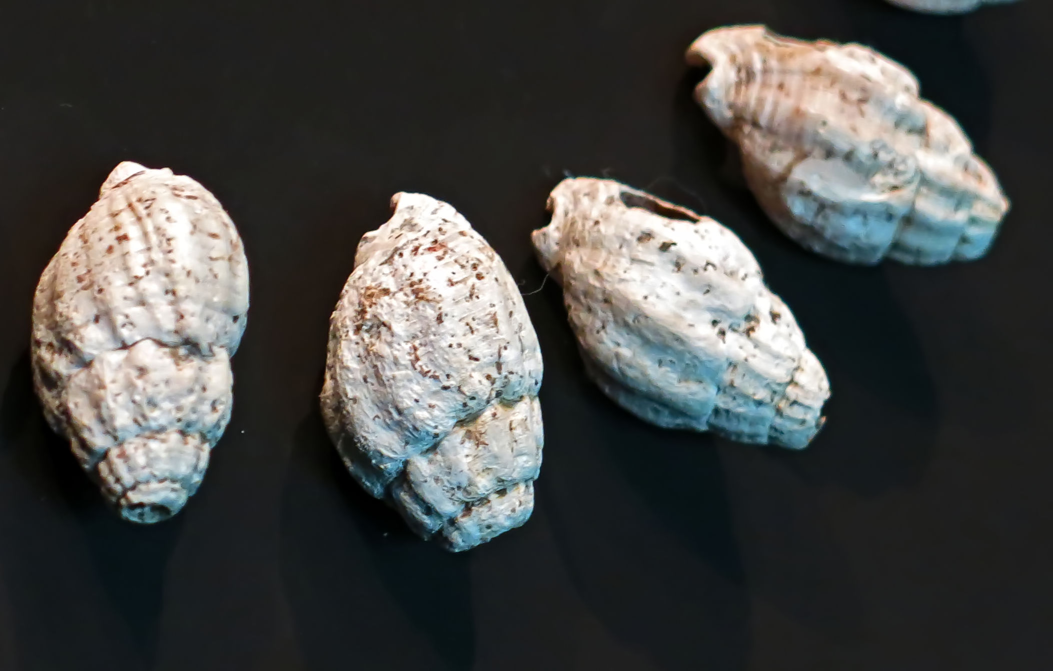
Close ups of some of the shells.
Photo: Don Hitchcock 2015
Source: Staatliche Museen zu Berlin, Neues Museum, Germany
Henry-Gambier and White (2003)
The question of the age of the Cro-Magnon and Combe-Capelle human fossils is clearly of considerable importance. Hominid specimens from both sites have played a critical role in the development of current perspectives on modern human origins in Western Europe.
The Cro-Magnon skeletal remains, discovered en 1868 near les Eyzies-de- Tayac by workmen and excavated by L. Lartet are routinely attributed to the Aurignacian culture. An AMS C14 date (27 680 ± 270 BP, Beta — 157439) of a shell associated with the human remains as well as cultural indications, demonstrates that these specimens postdate 28000 BP. The Cro-Magnon burials should not be attributed to the earliest Aurignacian, but rather to the Gravettian.
The Combe-Capelle skeleton was discovered by O. Hauser at the beginning of the twentieth century. According to him, the burial occurred at the interface between a Mousterian and an early Aurignacian (i.e. Châtelperronian) level. The supposedly Châtelperronan age of the skeleton (and the very authenticity of the skeleton itself), and its morphology, have long been the subject of debate. As the remains had until recently been thought to have been lost or destroyed during the last war, it was impossible to check the original data.
In 1990, the Combe-Capelle remains were rediscovered by A. Hoffmann and D. Wegner at the Museum für Vorund Frühgeschichte, Staatliche Museen zu Berlin (RFA). The morphological study of the Combe-Capelle skull, the analyses of associated shell ornaments and of available archives provide some new insight into the probable age of this specimen. This new analysis has quite important implications for our understanding of cultural and biological processes at the beginning of the Upper Paleolithic in Europe.
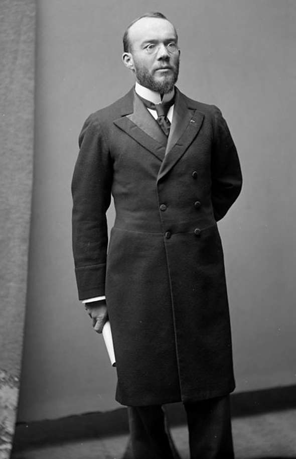
Henri-Marc Ami (November 23, 1858 – January 4, 1931) was a French Canadian archaeologist responsible for the initial excavation of Combe-Capelle from the years of 1926 until his death in 1931.
In 1900 he was elected to the Royal Society of Canada.
Photo and text: Wikipedia
Date: October 1897
Provenance:
Photographer: William James Topley (1845 - 1930)
The photo is in the public domain.
Text below from: www.thecanadianencyclopedia.com
Henri-Marc Ami, paleontologist, prehistorian (b at Belle-Rivière, Qué 23 Nov 1858; d at Menton, France 4 Jan 1931). The son of a Swiss pastor, Ami studied science at McGill, notably under John William DAWSON. He worked for the Geological Survey of Canada 1882-1911. Ami is best known for his work on geological formations in Québec and the Maritimes. His bibliography contains over 200 titles.
He was editor of the Ottawa Naturalist 1895-1900. In 1900 he was elected to the Royal Society of Canada, and the Geological Society of London honoured him with the Bigsby Medal 1905. His comfortable financial situation and marriage to Clarissa Burland, from a prominent Montréal family, allowed Ami to resign from the Geological Survey in 1911 to concentrate on prehistorical studies. After moving to France, he founded the École canadienne de préhistoire, an institution jointly funded by the French government and the RSC.
Text below from: http://www.montferrandduperigord.com/AGeneral.htm
The Prehistoric site of Combe-Capelle is a three tiered complex situated on a hillside in the Couze valley near the village of Montferrand-du-Périgord. At the top of the hill, at the foot of a small cliff, the caves of Roc de Combe-Capelle and Combe-Capelle Haut were the first to be excavated.
On the slope, Combe-Capelle Bas was excavated more recently. The Roc de Combe-Capelle discovered in 1887 was excavated by Mr Villereal and then by O.Hauser, who discovered in 1909 a skeleton belonging to the Chatelperronien. It was buried intentionally with a cloth and a twin-edged tool next to its left hand. It was a small man measuring 1.60m. Hauser published his discovery, sold the skeleton to the Berlin museum and gave a mold of it to the Périgueux museum.
The circumstances of the discovery, the exact position and the skull characteristics have been questioned by several prehistorians since the first criticisms by the prehistorian, Denis Peyrony.
The site, having been completely excavated, has lost its stratigraphy. The skeleton was destroyed in the Berlin fire of 1945 and so no analysis by modern methods is possible. Apart from the mold and old publications, nothing remains of this famous and controversial Combe-Capelle man.
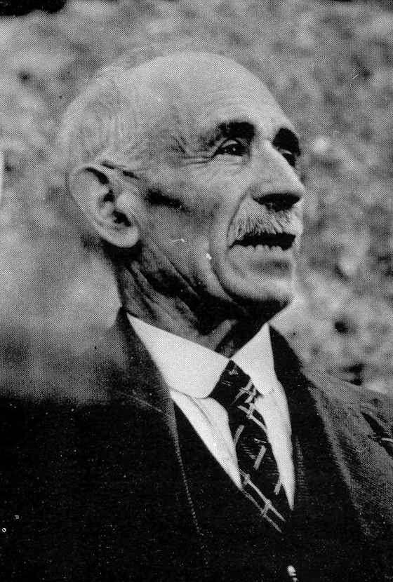
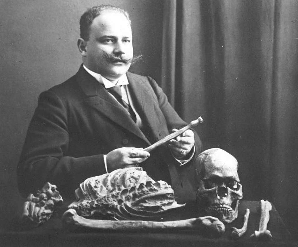
Denis Peyrony
Photo: http://www.montferrandduperigord.com/prehis2.htm
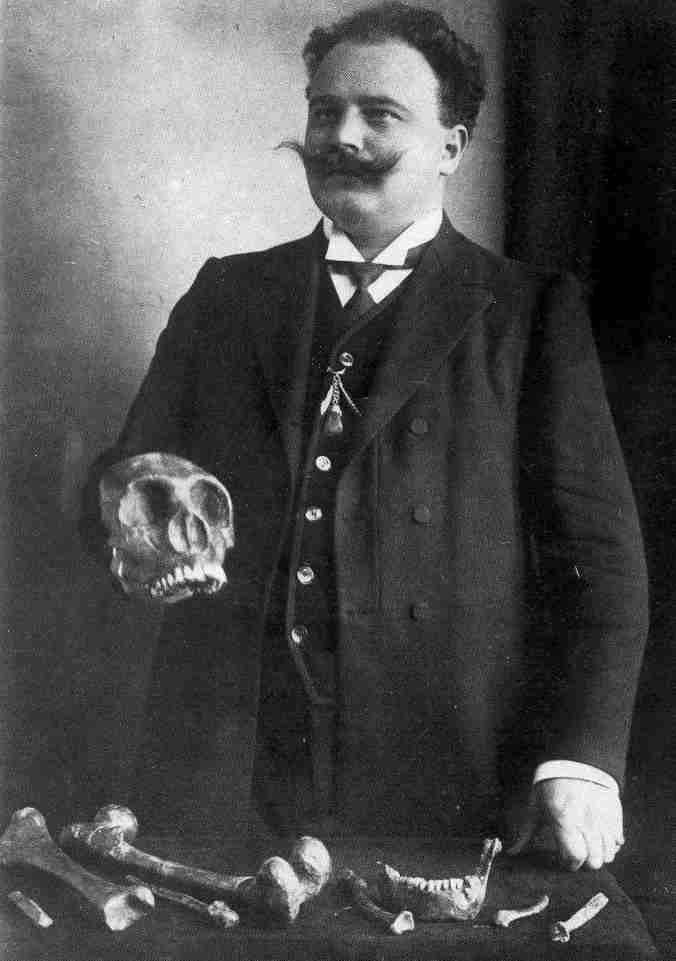
A cast of the skeleton and skull, the original skull on a postcard, and Otto Hauser with a different skeleton.
Photo: http://www.montferrandduperigord.com/prehis2.htm
Combe Capelle skeleton with Hauser
Photo: http://www.otto-hauser.de/bilder.php
Homo Aurignacensis Hauseri
Combe - Capelle, situated near the ancient town of Montferrand-du-Perigord (Dordogne), is the site of the discovery of another Palaeolithic skeleton by M. O. Hauser. While excavating in archaeological ground of the Aurignacien Age on the 26th August 1909, he exposed the upper portion of a human skull in a deposit which had not been disturbed by any previous excavators. The skull was not then removed, but was left in situ till the I2th September, when the discoverer secured the assistance of Professor Klaatsch, well known as an expert in human palaeontology. In the course of removing the bones, numerous perforated marine shells were observed in the vicinity of the head and neck, which evidently had served as some kind of ornament. The skeleton was that of a male subject, but its osteological characters were not those peculiar to the Neanderthal-Spy race.
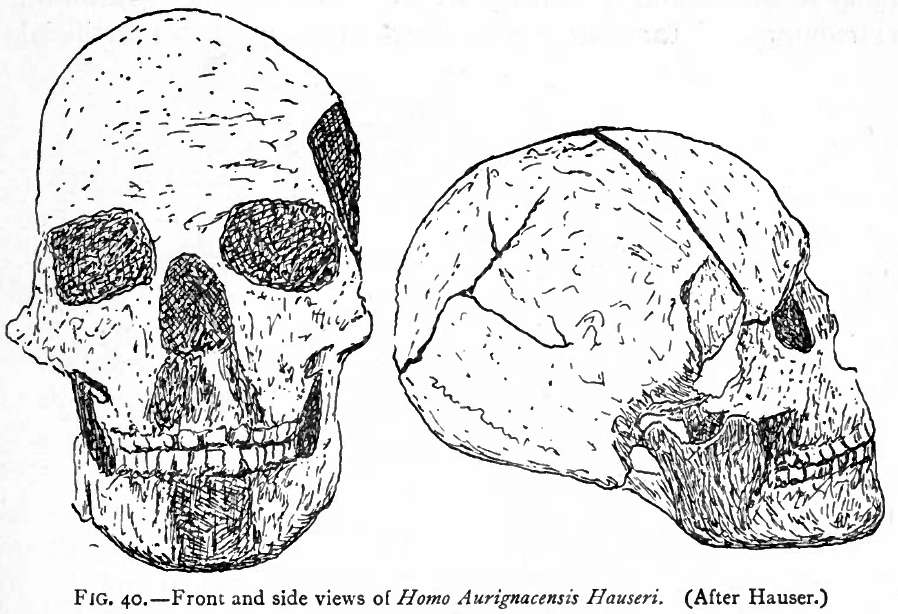
Front and side views of Homo Aurignacensis Hauseri. (After Hauser)
Photo: Munro (1912)
A lofty skull and forehead at once indicated a higher type of humanity ; but it is not on this account of less importance. To this, apparently novel race in the Dordogne, Professor Klaatsch has given the name Homo Aurignacensis Hauseri. The skull was extremely dolichocephalic, the face slightly prognathic, and the chin little developed. A peculiarity of the skeleton was the relative shortness of the limbs, the fore- arms and legs proper being no longer than the humerus and femur. The body was dumpy and the thorax voluminous, and both these as well as the limbs indicated powerful muscular action. It had been deposited in Mousterien debris, but the associated relics were characteristic of the Aurignacien Age, and were grouped about the head and feet. The race to which this fossil man belonged would appear to have occupied an intermediate position between the Neanderthal-Spy and Chancelade races, recalling in some respects the man of Galley Hill in Kent. (L'Homme Prehistorique, 1909, p. 341.)
References
- Breuil, H., 1909: L'Aurignacien présolutréen. Epilogue d'une controverse Revue préhistorique, IV, 1909, p. 270, fig 2.
- Dibble, H. and Lenoir, M., 1995: The Middle Paleolithic site of Combe-Capelle Bas, University of Pennsylvania Museum Publication, December 1995, ISBN-10: 0924171383 ISBN-13: 978-0924171383
- Eshleman C., 2003: Juniper Fuse: Upper Paleolithic Imagination & the Construction of the Underworld, Wesleyan University Press 2003
- Groenen Marc, 1994: Pour une histoire de la préhistoire, Éditions Jérôme Millon 1994
- Henry-Gambier D., and White R., 2003: New chrono-cultural data on the Cro-Magnon and Combe-Capelle human remains (Dordogne, France): consequences for the biocultural origins of modern humans in Europe Paleoanthropology Society Abstracts for the 2003 Meetings, Tempe, AZ
- Keith, A. , 1915: The Antiquity of man, Philadelphia: J.B. Lippincott company; London: Williams and Norgate
- Lenoir, M., 1995: The Middle Paleolithic Site of Combe-Capelle Bas (France), UPenn Museum of Archaeology, 1995 - History - 363 pages
- Munro, R., 1912: Paleolithic Man and Terramara Settlements in Europe, Edinburgh: Oliver & Boyd. 1912 (out of copyright)
- Peyrony, D., 1943a: Combe-Capelle, Bulletin de la Société préhistorique de France, Année 1943 Volume 40 Numéro 10 pp. 243-257
- Peyrony, D., 1943b: Le Gisement Du Roc De Combe Capelle (Commune de Saint-Avit-Sénieur, Dordogne), Bulletin Société historique Périgord , 0, 1943, S. 156–173, (Périgueux).
- Soressi, M., McPherron S., Lenoir M., Dogandzic T., Goldberg P., Jacobs Z., Maigrot Y., Martisius N., Miller C., Rendu W., Richards M., Skinner M., Steele T., Talamo S., Texier J., 2013: Neandertals made the first specialized bone tools in EuropePNAS, www.pnas.org/cgi/doi/10.1073/pnas.1302730110
- Valladas, H., Mercier N., Joron, J., McPherron, S., Dibble H., Lenoire M. , 2003: TL dates for the Middle Paleolithic site of Combe-Capelle Bas, Journal of Archaeological Science 30 (2003) 1443–1450
Back to Don's Maps
 Back to Archaeological Sites