Maori Forts - Pa
Maori Pa
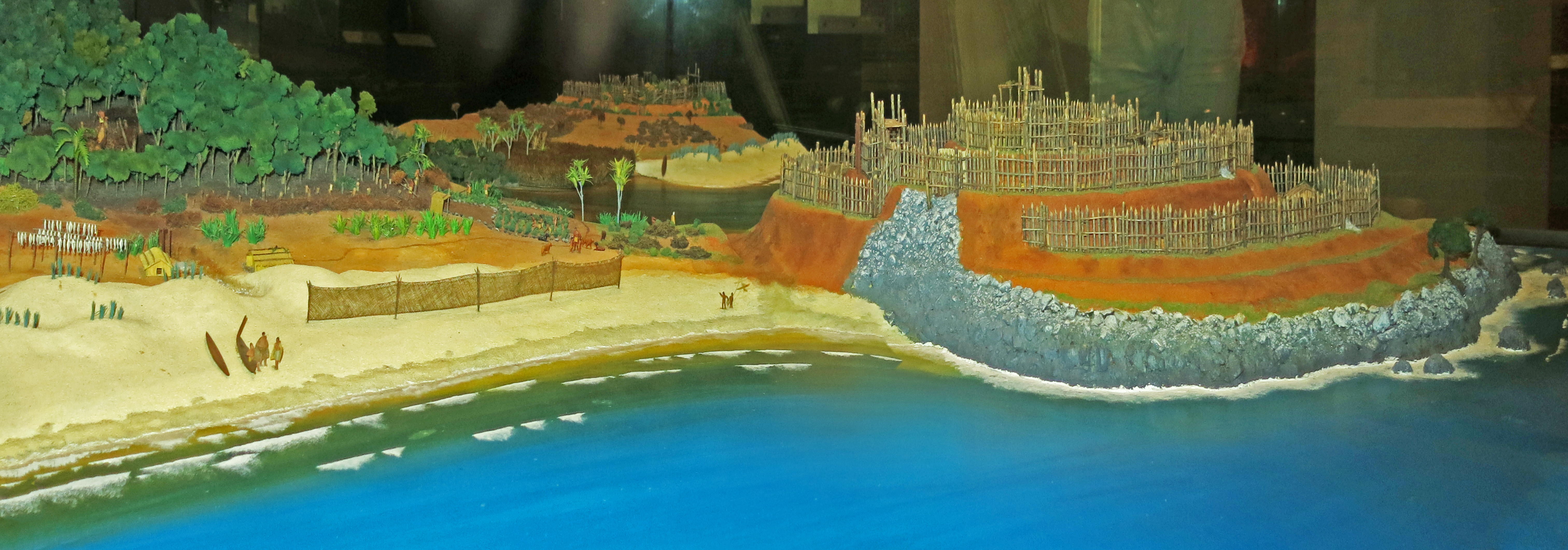
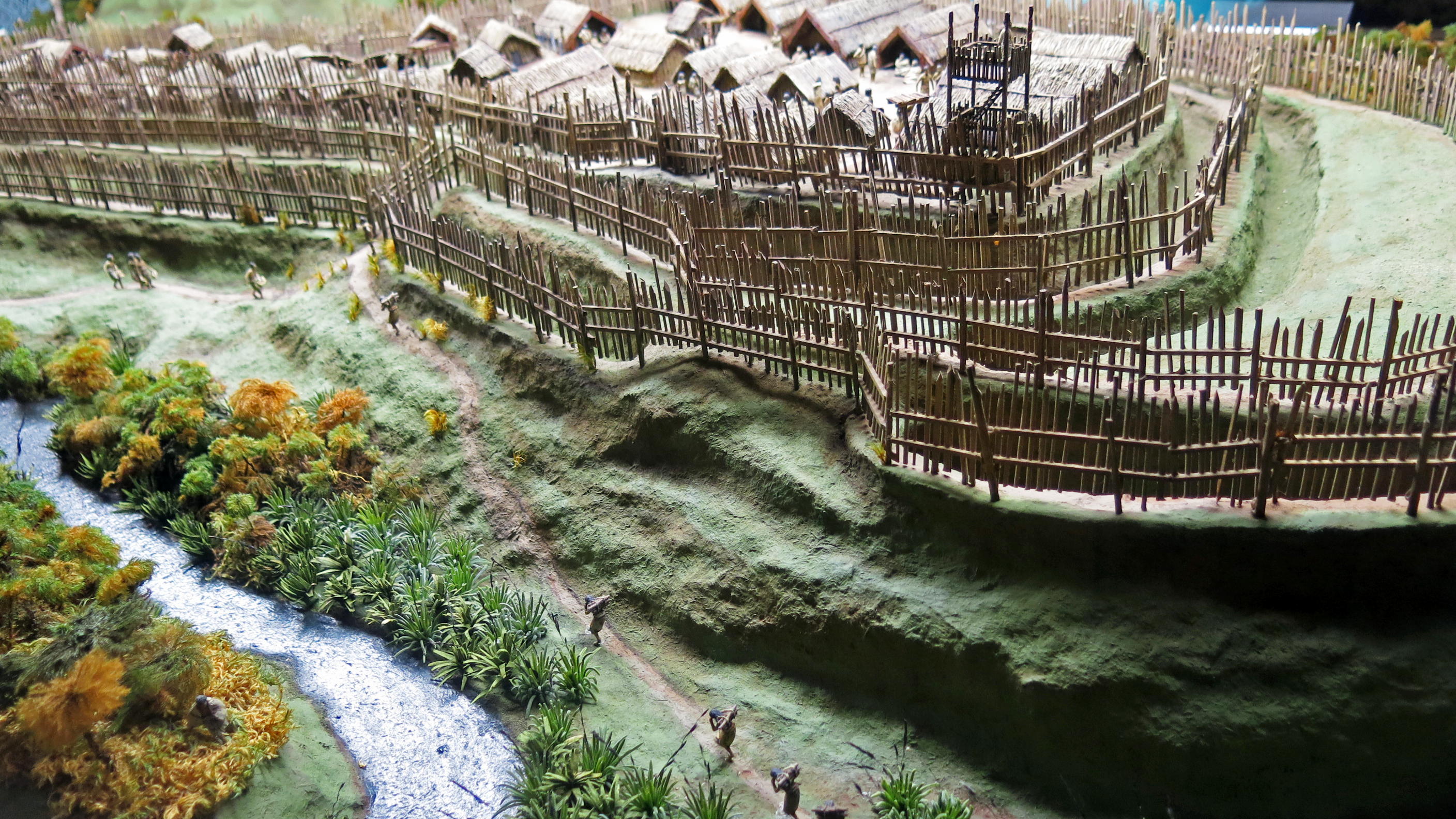
The pā depended for its continued existence on a good food and water supply, as well as a defensible position. This was achieved by siting the pā on a prominence, but with access to a river and forest, and with fertile land suitable for cultivation nearby. This hypothetical site has all of this, as well as access to the sea, the ideal situation, since the Māori were skilled fishermen, and were able to make very seaworthy fishing boats.
Photo: Don Hitchcock 2015
Source: Display, Auckland Museum
The word pā can refer to any Māori village or defensive settlement, but often refers to hill forts - fortified settlements with palisades and defensive terraces - and also to fortified villages. Pā are mainly in the North Island of New Zealand, north of Lake Taupo. Over 5000 sites have been located, photographed and examined although few have been subject to detailed analysis. No pā have been yet located from the early colonisation period when early Polynesian-Māori colonisers lived in the lower South Island. Variations similar to pā are found throughout central Polynesia, in the islands of Fiji, Tonga and the Marquesas Islands. In Māori culture, a great pā represented the mana and strategic ability of an iwi (tribe) as personified by a rangatira (chiefs). Pā are located in various defensible locations around the territory (rohe) of an iwi to protect fertile plantation sites and food supplies.
Almost all pā are found on prominent raised ground, especially volcanic hills. The natural slope of the hill is then terraced. Dormant volcanoes were commonly used for pā in Auckland. Pā are multipurpose in function. Pā that have been extensively studied after the New Zealand Wars and more recently were found to safeguard food and water storage sites or wells, food storage pits (especially kūmara, sweet potato), and small integrated plantations, maintained inside the pā. Recent studies have shown that in most cases, few people lived long term in a single pā, and that iwi maintained several pā at once, often under the control of a hapū (subtribe). The area in between pā were primarily common residential and horticultural sites. A tourist attraction of authentic pā engineering is at Maungawhau / Mount Eden.
Text above: Wikipedia
Maru Pā
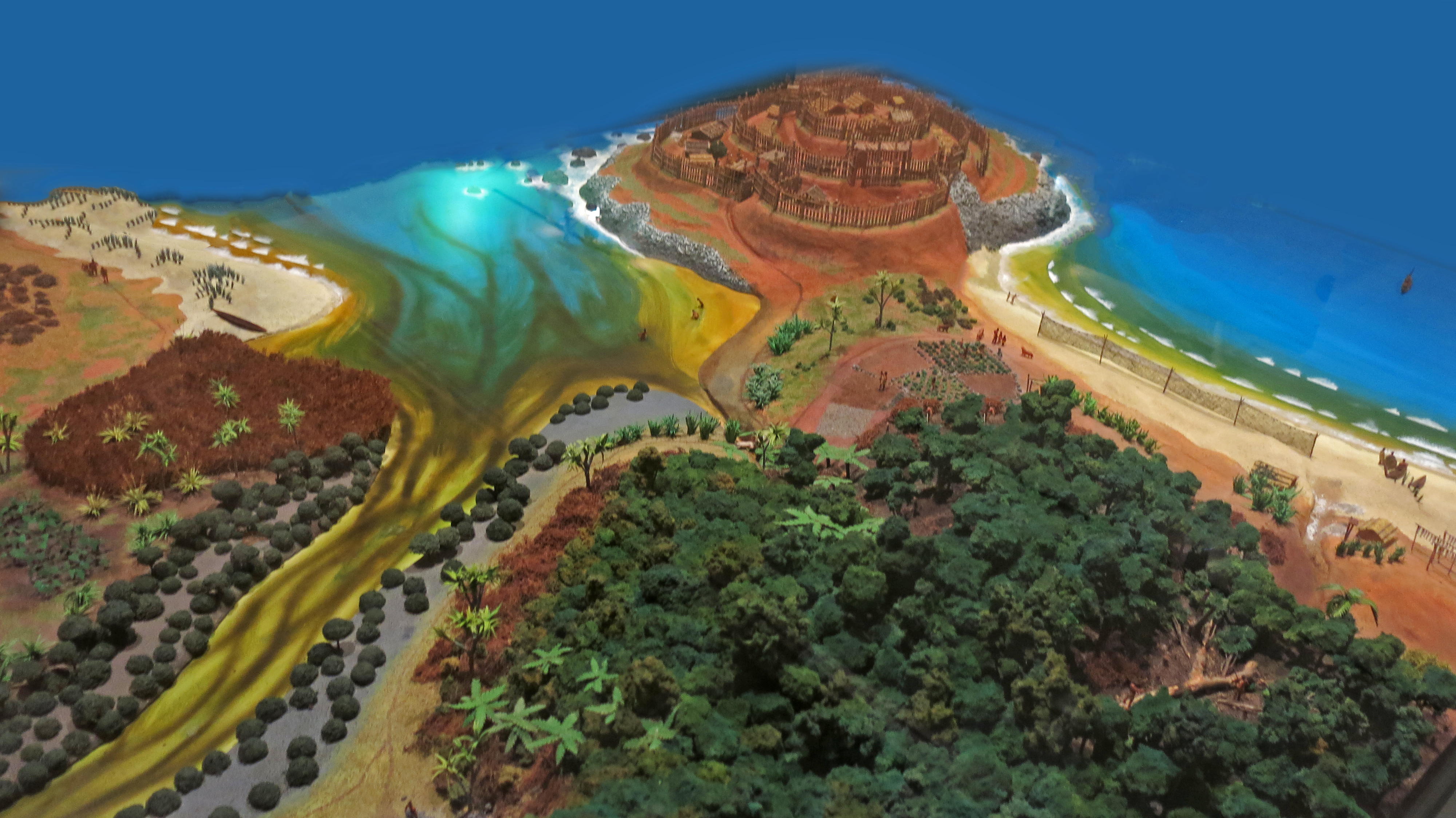
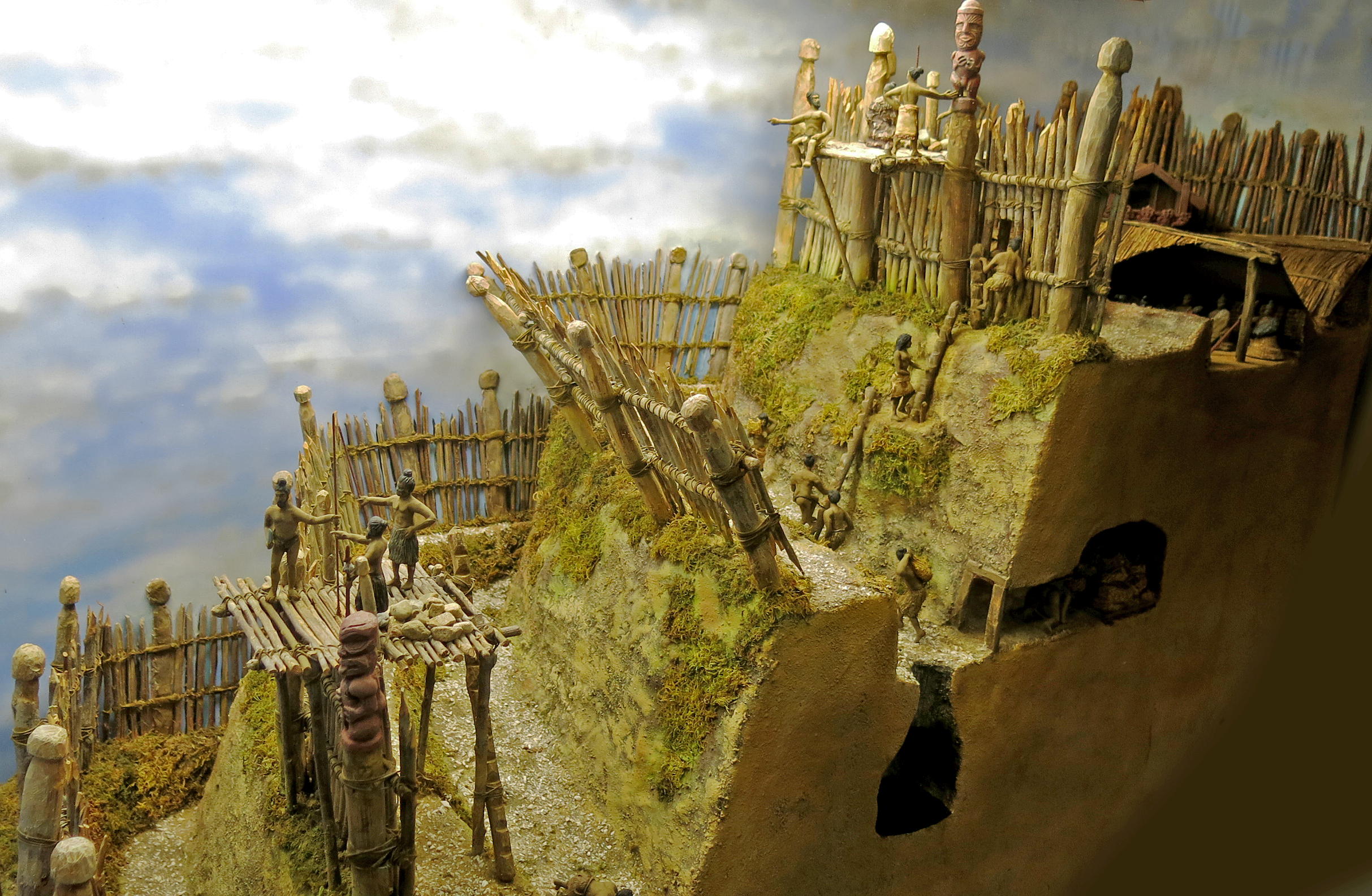
This pa was built on the slopes of Mount Taranaki, on the west side of the mountain on a scrub-covered hill. The Taranaki Māori built Maru Pā ('shelter') as defence against musket raids in the early 19th century. It was also an important place of higher learning.
Despite its natural defences, shown in this excellent diorama, and the determined efforts of the people sheltering there, it fell in 1826, and its people were killed or enslaved.
Photo: Don Hitchcock 2015
Source and text: Visitor Display Centre, Taranaki National Park
Artist and sculptor: Not attributed, but it is obviously the work of the very talented artist Nigel Ogle, whose Tawhiti Museum is a must see for visitors to the Taranaki area.
Turuturu Mokai Pā
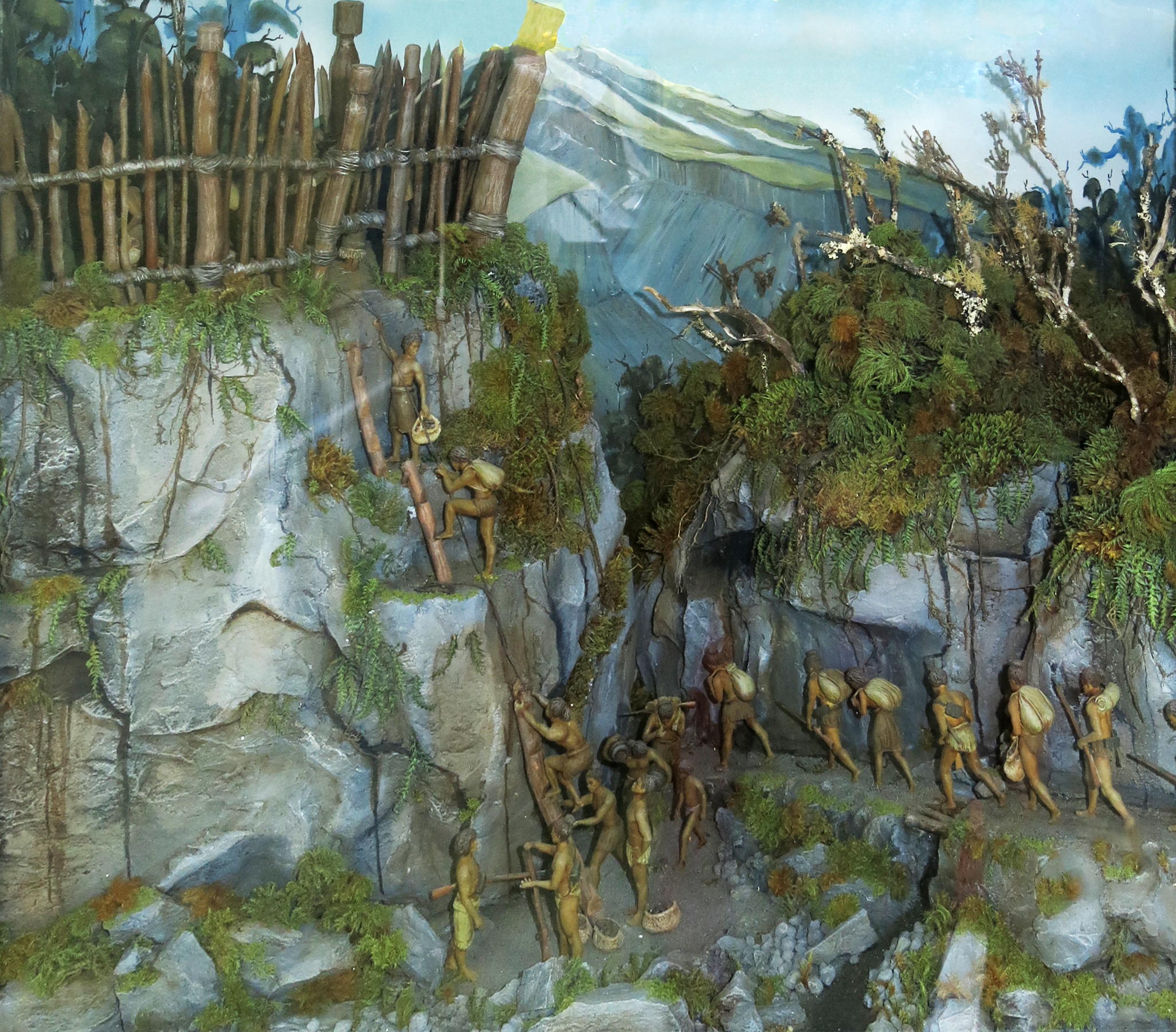
This massive pā, still visible today and situated 3 km from the Tawhiti Museum, in the Taranaki region, was built over 400 years ago by Ngatī Tupaea, a hapū (sub-tribe or clan, the basic political unit within Māori culture) of Ngāti Ruanui.
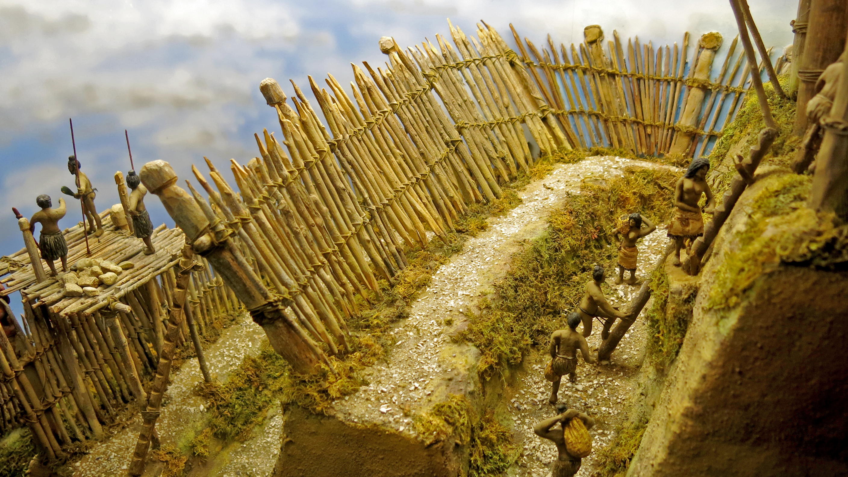
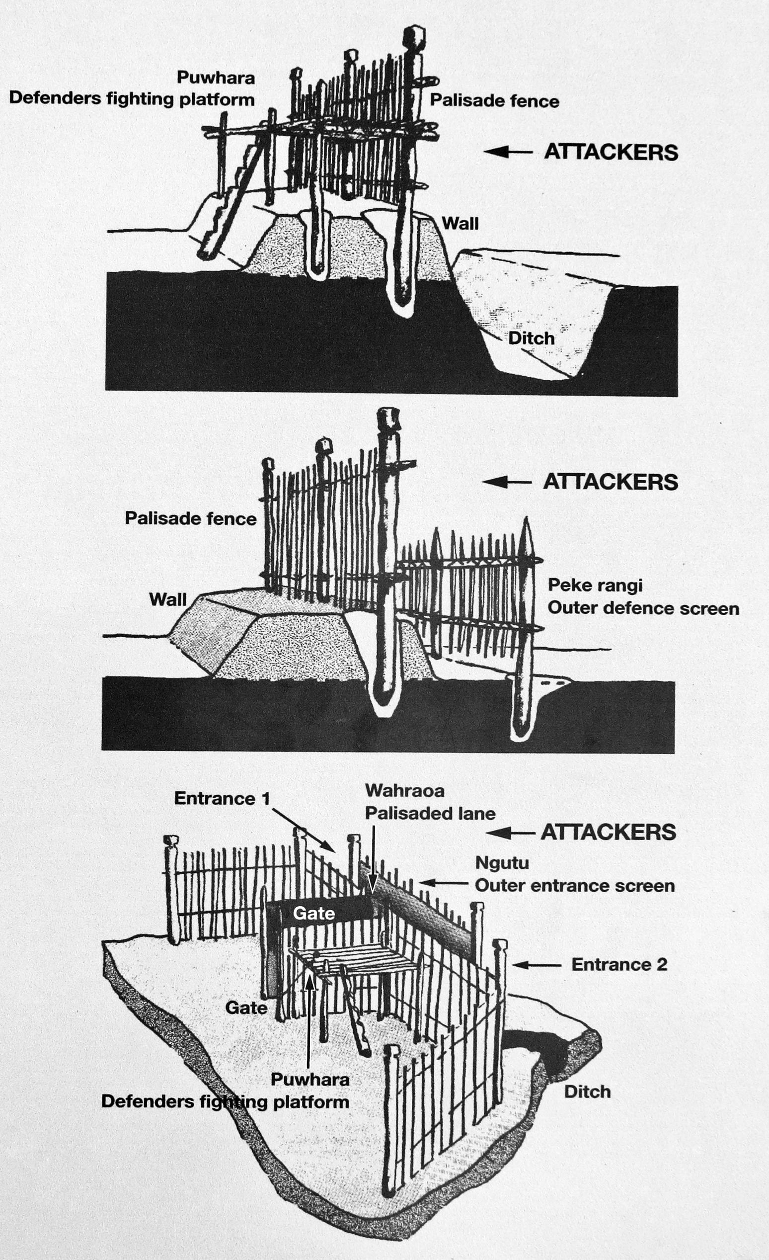
Wherever possible a pa would take advantage of natural defences - steep hills and cliffs, river or coastal perimeter etc. However there was almost always a need to improve defences with strong wooden fences (tuwatawata ) and deep trenches. Turuturu Mokai was not a particularly steep site, so great effort went into triple rows of trenches and palisades.
Photo: Don Hitchcock 2015
Source and text: Display, Tawhiti Museum
Artist and sculptor: Nigel Ogle
Additional text: Wikipedia
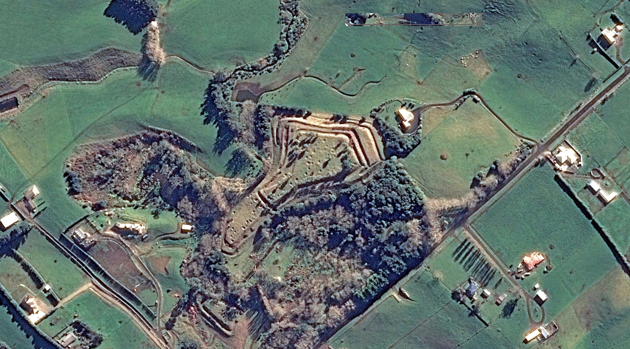
The site is an extremely large and awe-inspiring set of Maori earthworks built in the 17th century by the Ngāti Tupea, and restored in the 1930s. In pre-European times a battle was fought there between the Ngati Tupea garrison of about 1000 men and a raiding party of Taki Ruahine (a sub-tribe of the Ngāti Ruanui).
A strategem was used during a time of relative peace, and Tūraukawa Poroa, a Ngāti Taki Ruahine rangatira (chief), organised a tohunga-te-moko, or Maori tattoo artist to be placed at the pā, offering to tattoo the warriors of the garrison, in particular on the buttocks and thighs. They accepted. Maori facial and body tattooing is a long and painful operation, after which the tattooed is incapacitated for a few days.
With the Ngāti Tupea so rendered, the Taki Ruahine came and took the pa with great slaughter. They decapitated the Ngāti Tupea dead and impaled their severed and smoke-dried heads on stakes thrust into the ground. Soon afterwards the pa was declared tapu and vacated, a tapu not removed until 1938. The name Turuturu Mokai indicated the stakes on which the heads of the slain enemy were mounted to warn prospective attackers of their likely fate.
Photo: Google Earth
Text: http://home.earthlink.net/~cyberkiwi/soldiers/battles.html
and Sole 2005

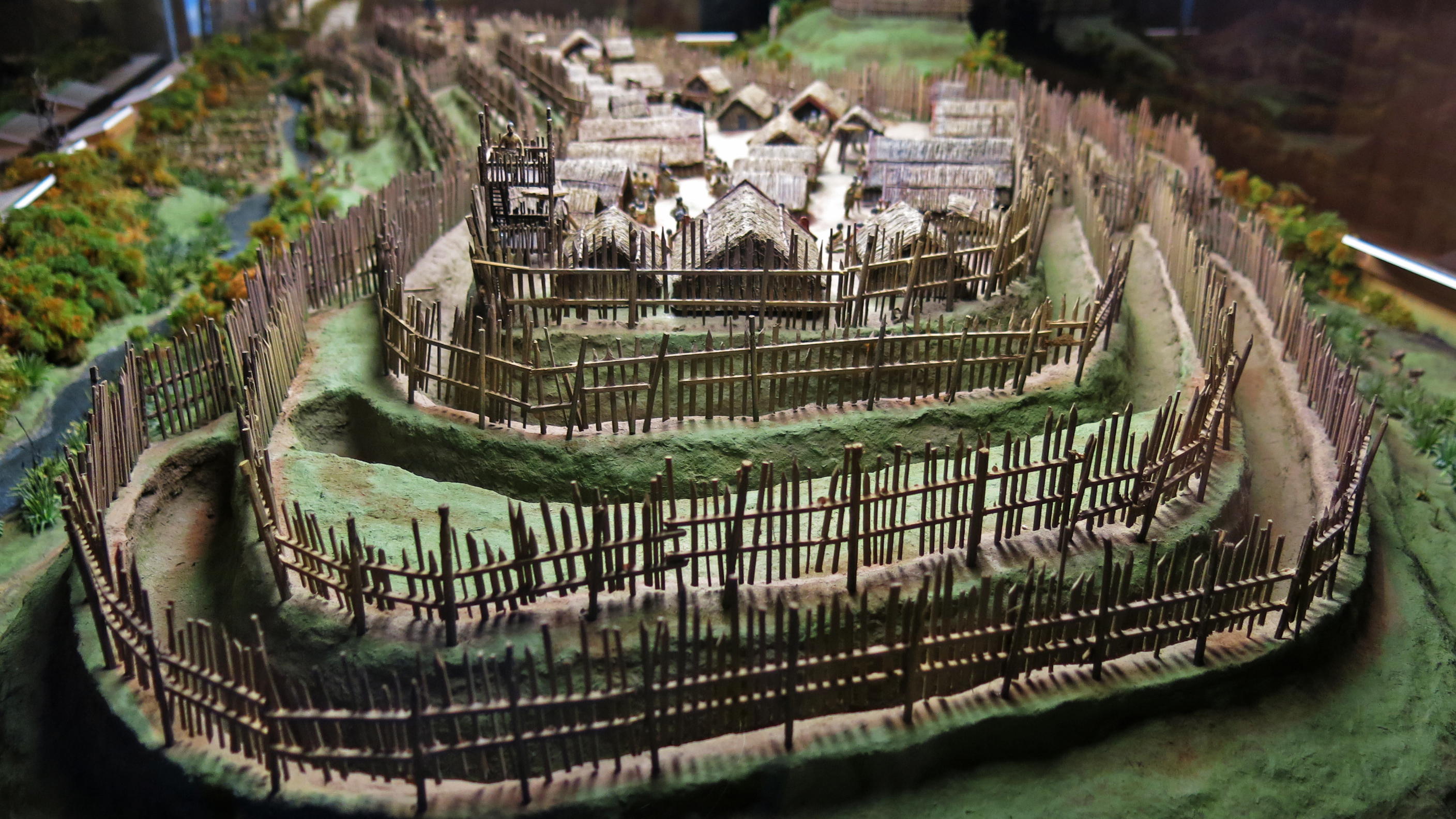
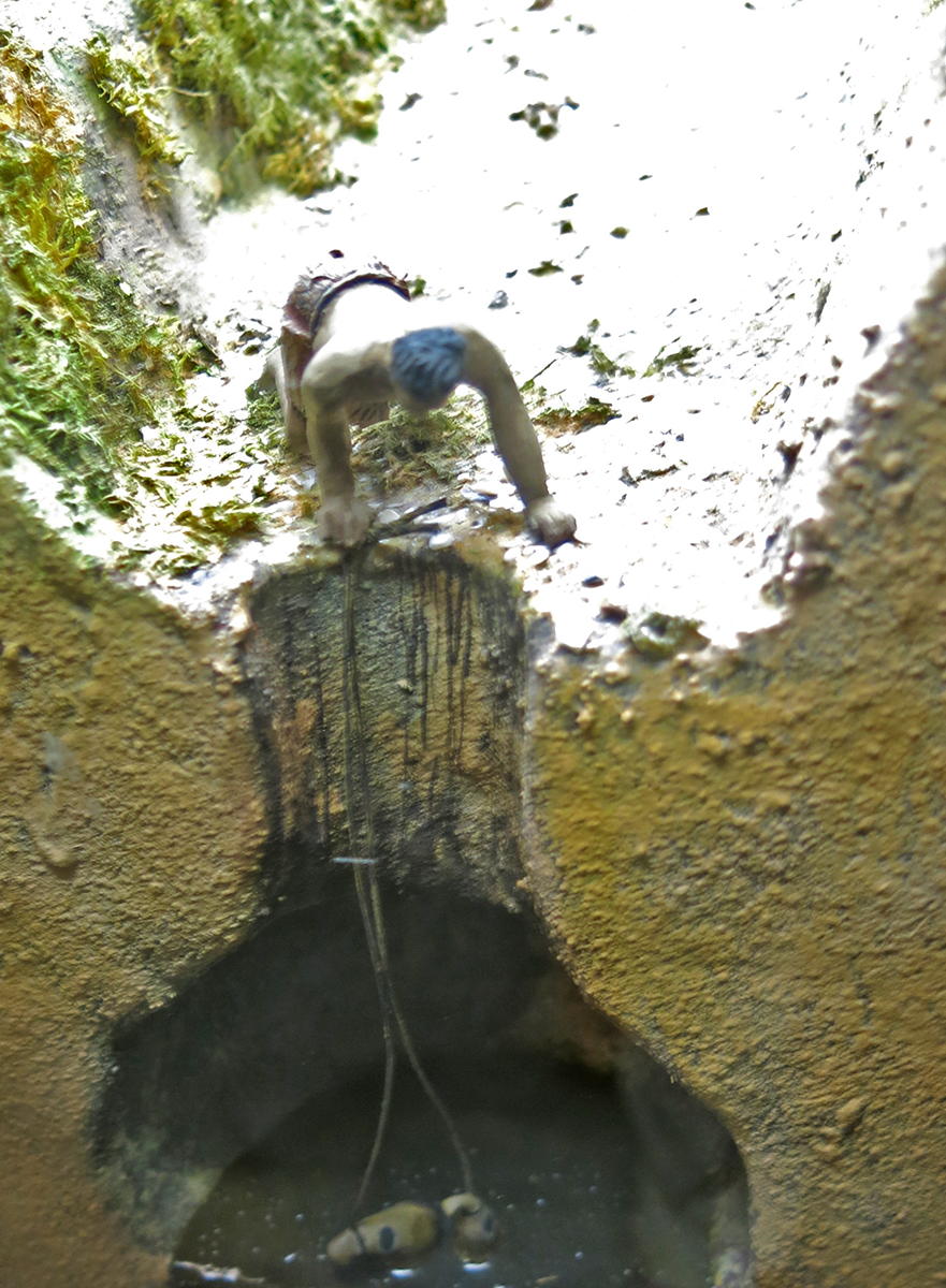
Built in a loop of the Tawhiti stream, the main pā was ringed by five adjacent smaller pā - only one of which exists today. One of those was connected to the main pā by a tunnel under the Tawhiti stream.
The pā's fortifications included a series of ditches and palisades, augmented by watchtowers to provide early warning of attack. Stones were placed ready to hand to drop on invaders.
Photo: Don Hitchcock 2015
Source and text: Display, Tawhiti Museum
Artist and sculptor: Nigel Ogle
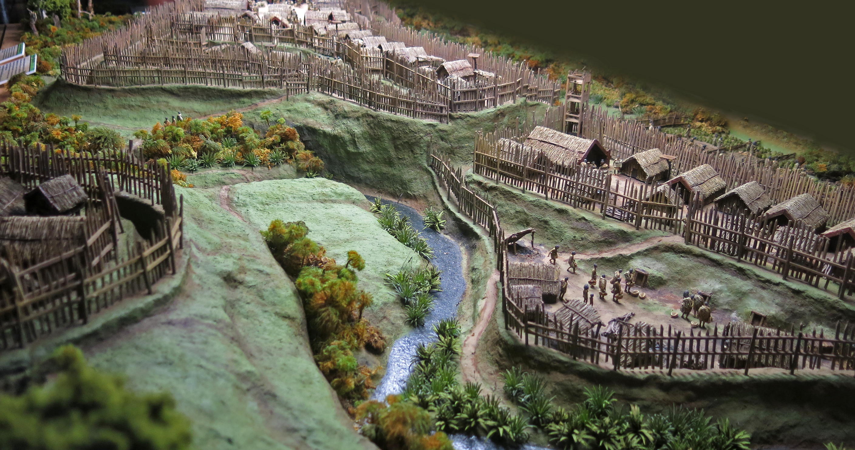
Two of the smaller Pā beside Turuturu Mokai Pā
Eels (tuna ) were a vital part of an inland pā's diet, but the streams and swamps also supplied freshwater mussels and crayfish, whitebait, watercress, and a range of freshwater fish.
There were three main methods of storing food and other valued objects - in elevated store houses (pataka ), elevated platforms (whata ), and underground pits (rua ). Some pataka were elaborately carved.
Photo: Don Hitchcock 2015
Source and text: Display, Tawhiti Museum
Artist and sculptor: Nigel Ogle
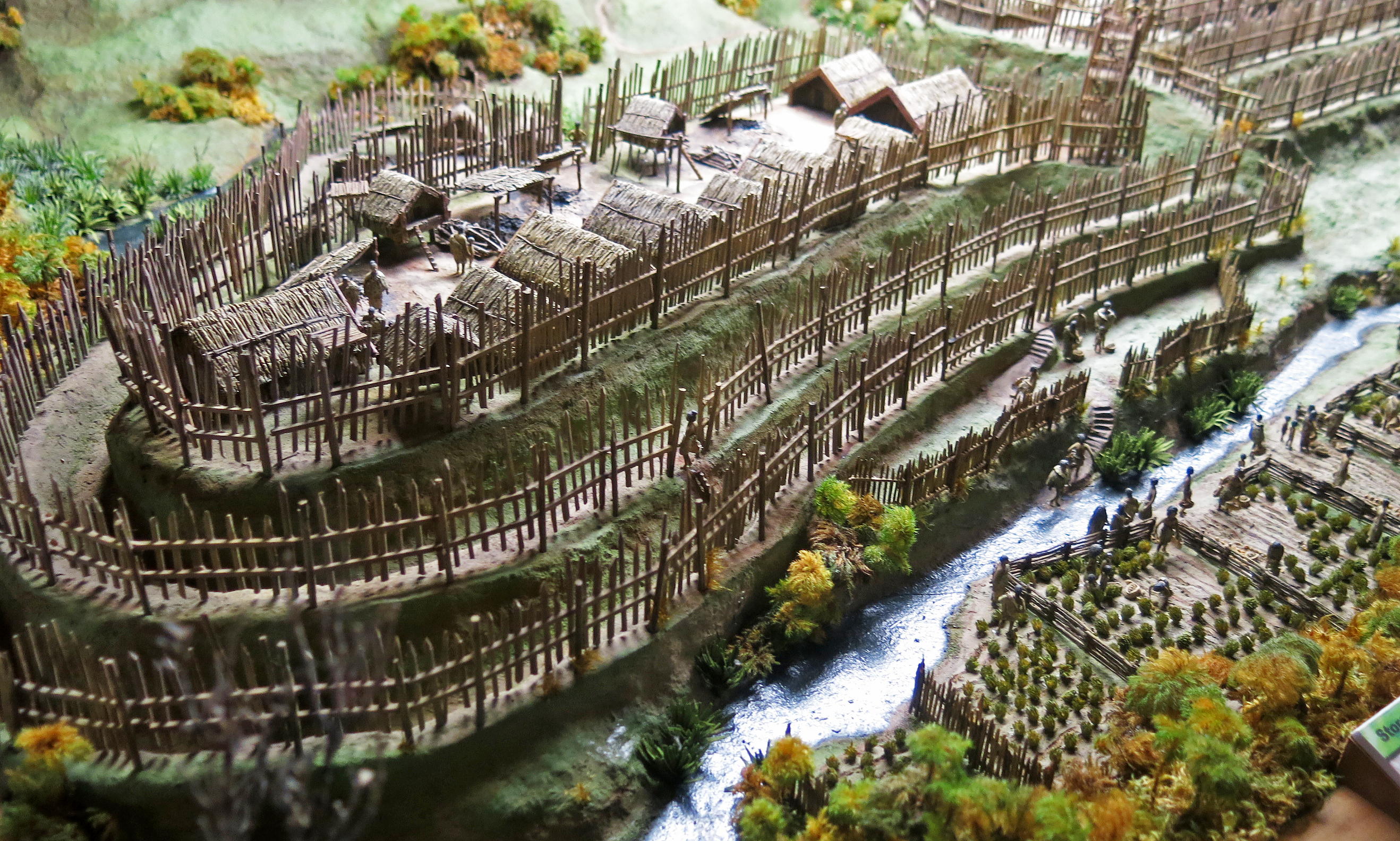
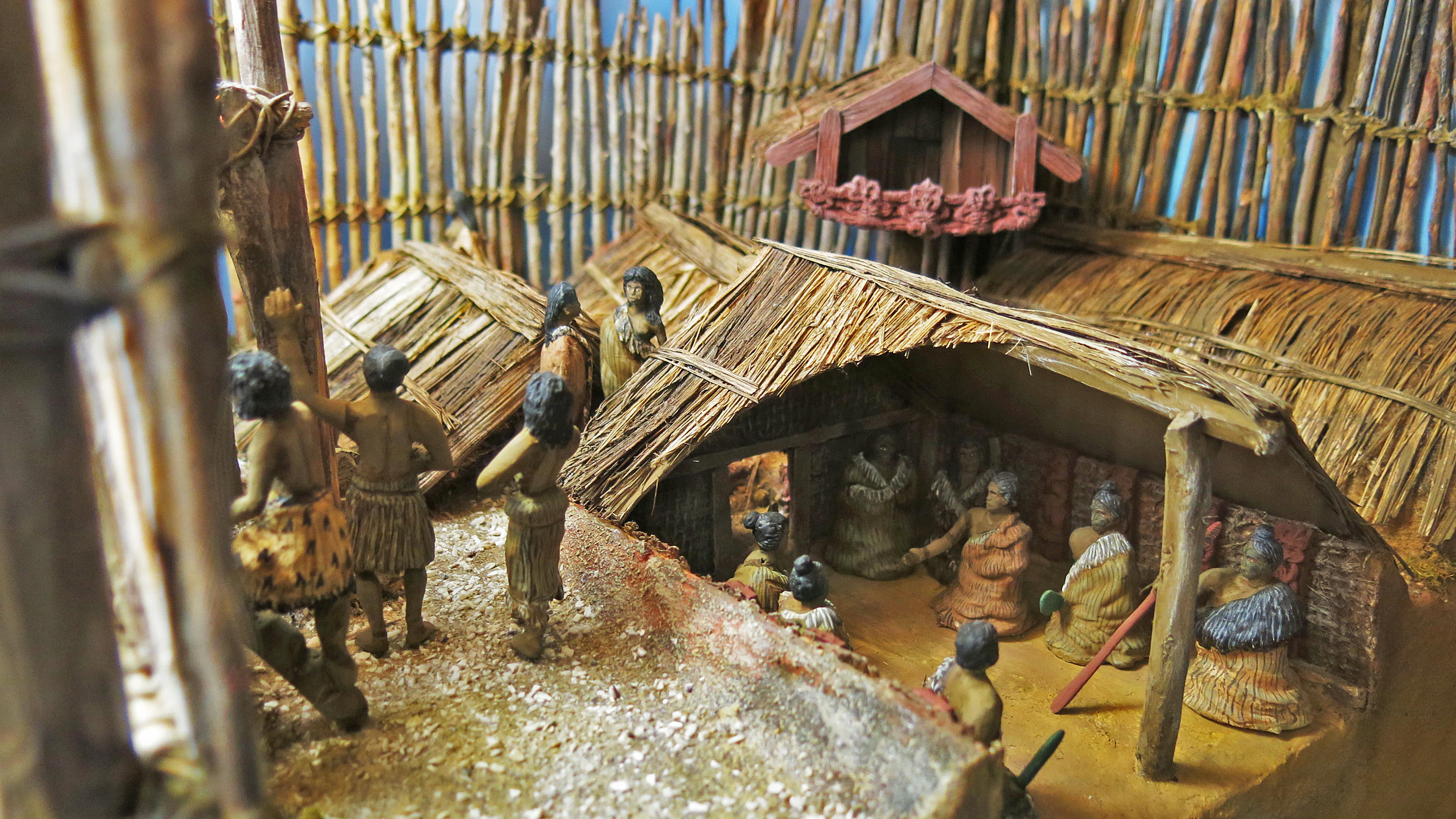
Buildings ranged from small sleeping huts (whare ) to large meeting houses (wharenui, wharewhakairo, wharepuni ). Timber, reeds, bark and fronds were employed in their construction.
Photo: Don Hitchcock 2015
Source and text: Display, Tawhiti Museum
Artist and sculptor: Nigel Ogle
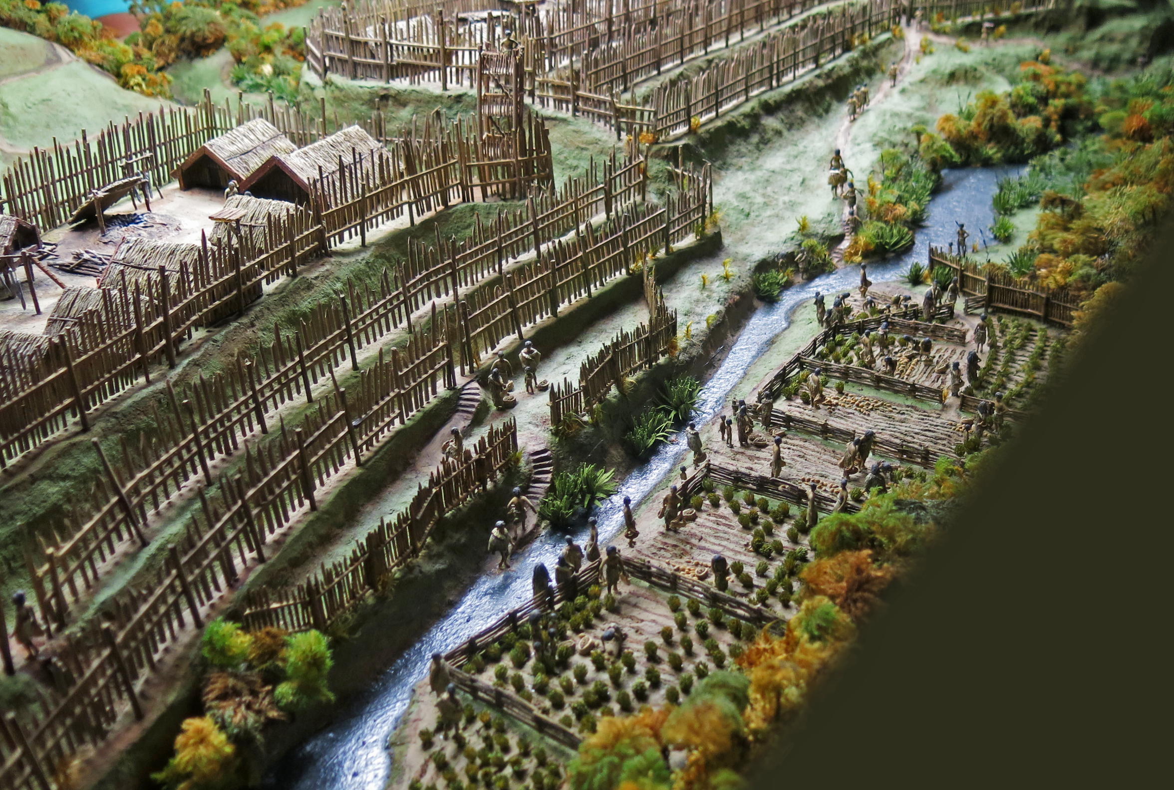
The four main plants cultivated were kumara, gourd, yam, and taro. In Taranaki, sand and gravel were often added to the soil to improve drainage and help raise soil temperature. Fences were built to keep out swamp birds, to act as wind breaks, and to delineate family plots.
Photo: Don Hitchcock 2015
Source and text: Display, Tawhiti Museum
Artist and sculptor: Nigel Ogle
Cooking fires and heating meant that dry firewood was in constant demand. With a large population, it would have been necessary to gather wood from increasingly greater distances, as shown here by the people carrying bundles of firewood to the pā.
The bush would supply many foods to supplement cultivated crops - birds, berries, bats, cabbage tree and tree fern pith, fern root, fungi, honey, grubs and insects.
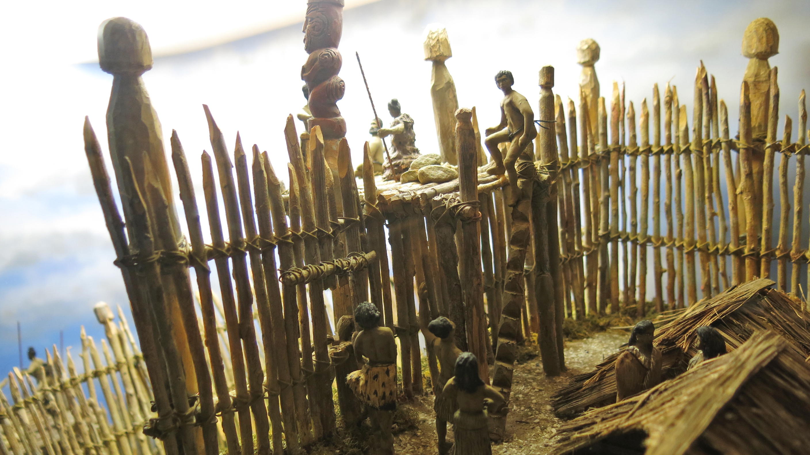
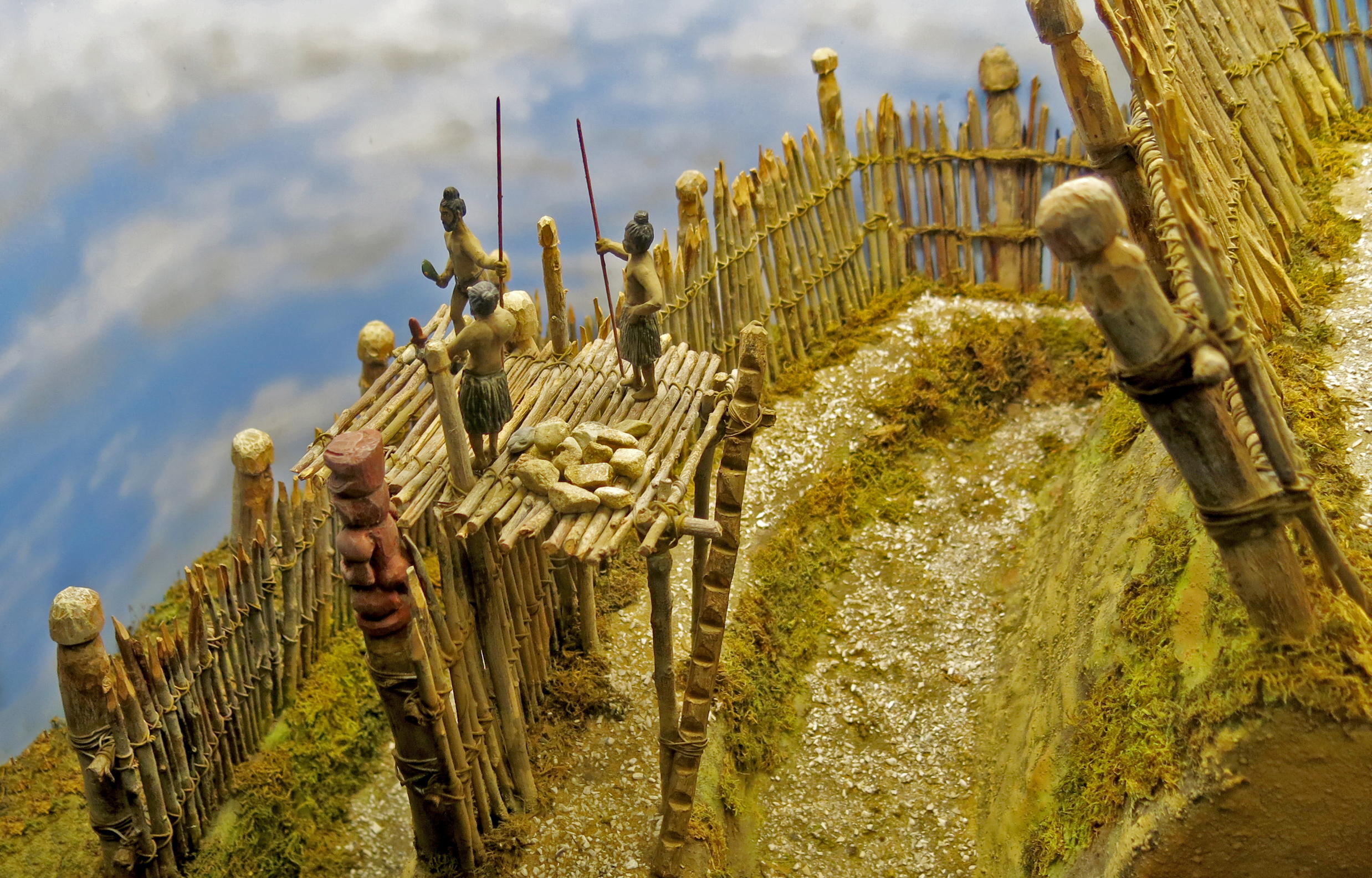
At strategic points in the stockade of a pā, tall towers (taumaihi ) were built to give sentries a clear view of approaching groups of people. They also doubled as a platform to hurl stones and spears at any enemy below.
Photo: Don Hitchcock 2015
Source and text: Display, Tawhiti Museum
Artist and sculptor: Nigel Ogle
The typical pā in pre-European times was built on a high prominence, with good sight lines to see anyone who approached. It needed flat, fertile soils nearby to grow food for the community, and bush close by as well to provide wood for firewood and for construction. Ideally, the pā would also have a good water supply within the outer perimeter of the pā.
Watch towers served the double purpose of early warning of people approaching, and served as defence as well, with a plentiful supply of rocks kept there to throw down on attackers, and watchers carried spears to hurl at the invaders from on high.
Photo: Don Hitchcock 2015
Source: Display, Tawhiti Museum
Artist and sculptor: Nigel Ogle
Since ground water follows, to some extent, the contours of the land above it, the water table under a pa was often able to be reached by a relatively shallow well. This was a very important addition to a pā, and was essential in pre-European times, when the common method of attack was a many months long seige, to starve the inhabitants out of their redoubt.
Photo: Don Hitchcock 2015
Source: Display, Tawhiti Museum
Artist and sculptor: Nigel Ogle
Within the pā were many structures, for meeting rooms, for sleeping, and for storage of foods and weapons.
Photo: Don Hitchcock 2015
Source: Display, Tawhiti Museum
Artist and sculptor: Nigel Ogle
The price of freedom was eternal vigilance. If the pā was attacked and taken, the survivors inside got no mercy. They could expect to be either murdered or enslaved, with the smoked heads of the defenders placed on the spikes of the pā as a warning to others.
Photo: Don Hitchcock 2015
Source: Display, Tawhiti Museum
Artist and sculptor: Nigel Ogle
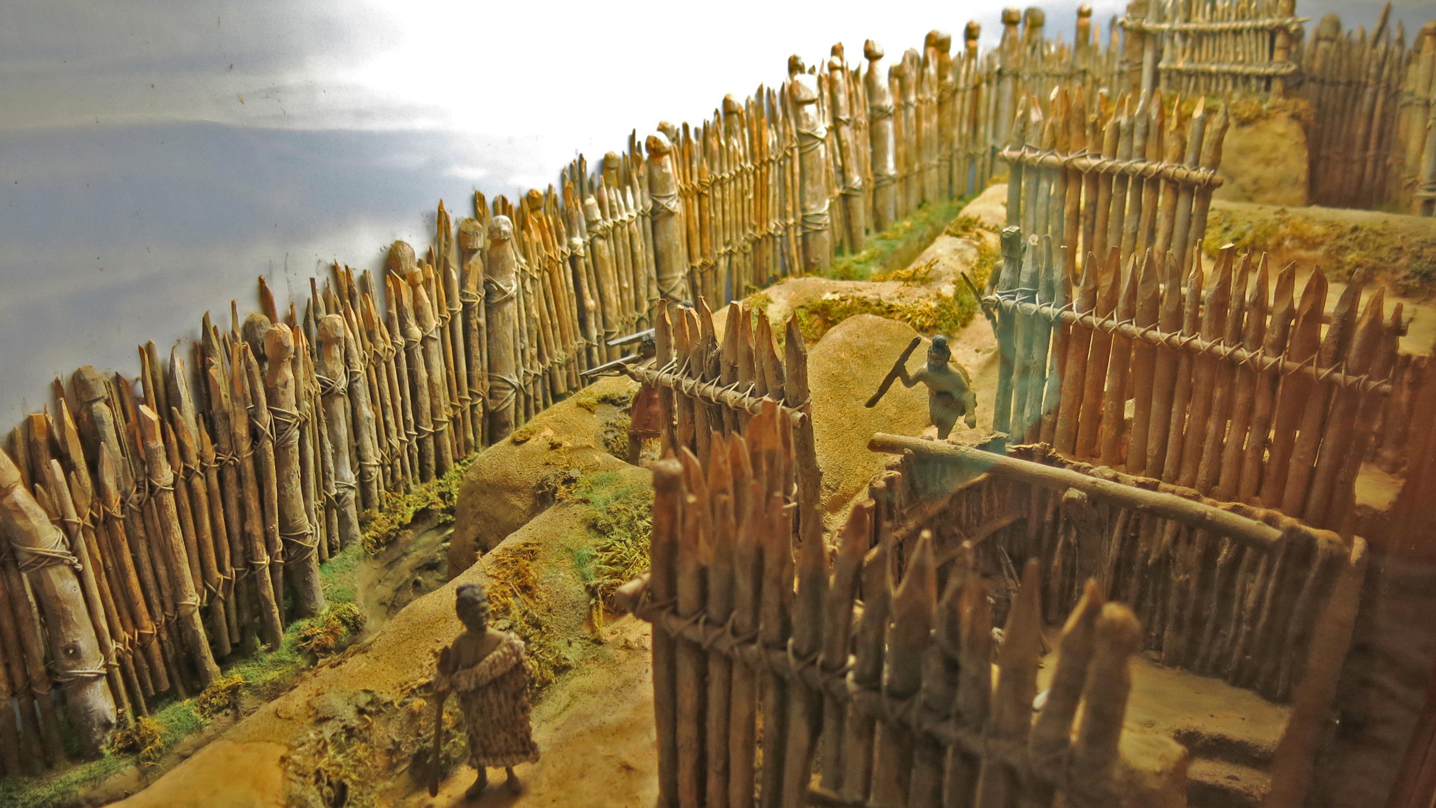
Some of the palisades were made to slope outwards in order to make scaling them difficult. Entry points were closed when the pā was attacked, and vigorously defended.
Photo: Don Hitchcock 2015
Source: Display, Tawhiti Museum
Artist and sculptor: Nigel Ogle
Entry points were closed when attack threatened, and vigorously defended.
As shown here, there was no easy way to get to the uppermost level, and when attackers got to the last ditch, the ladders were removed.
Photo: Don Hitchcock 2015
Source: Display, Tawhiti Museum
Artist and sculptor: Nigel Ogle
Structural Changes to the Pā during the time of the Māori Musket Wars, and the time of the Māori - Pākehā Wars
The trench as shown here was formed in a zig zag pattern to prevent the fire of attackers from travelling the length of the trench.
In addition, the outer wall was doubled to help prevent accurate or effective fire from outside.
Photo: Don Hitchcock 2015
Source: Display, Tawhiti Museum
Artist and sculptor: Nigel Ogle
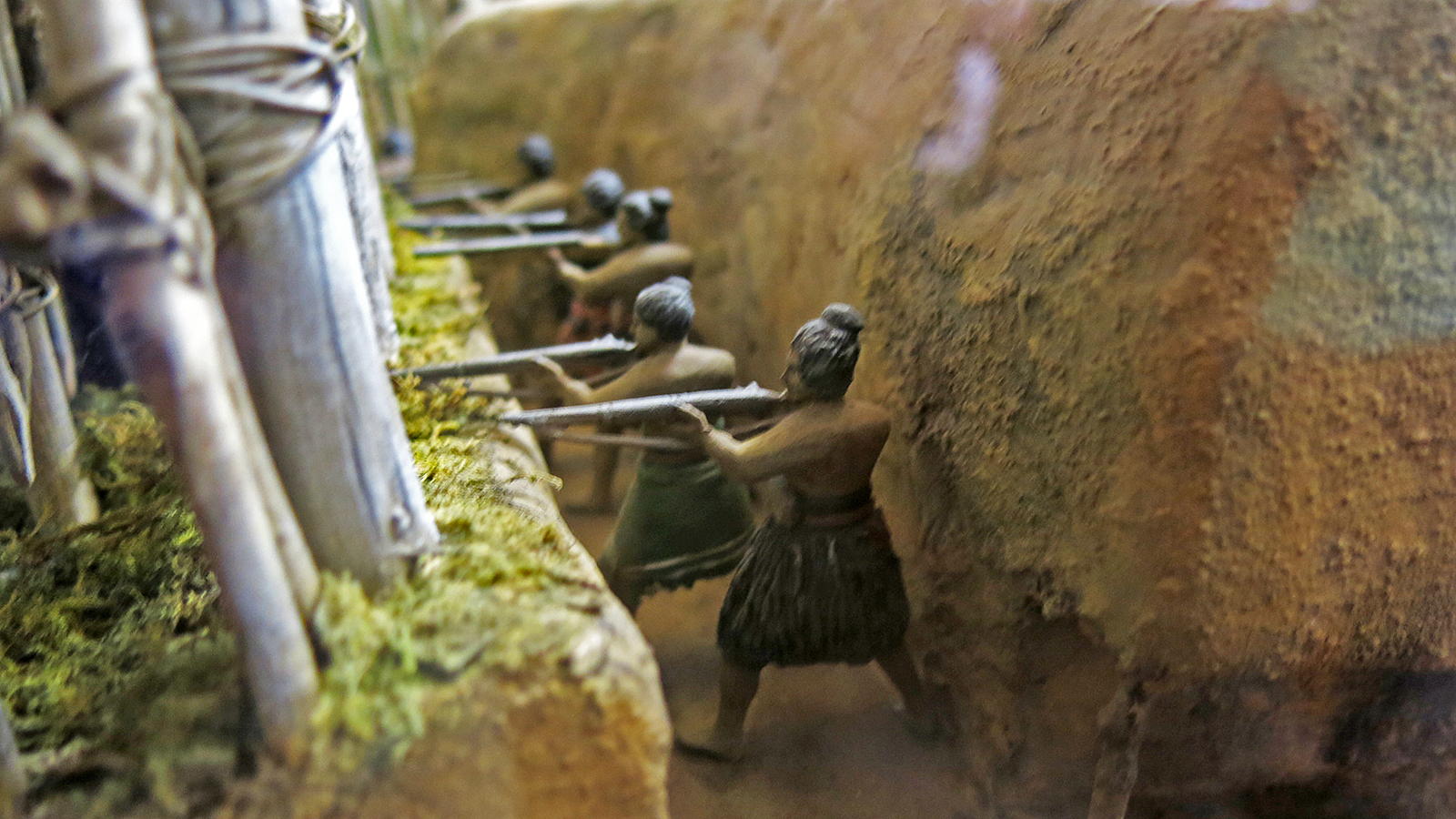
Clear lines of fire were, however, put in place from within the pā to the outside, and the trench wall was high enough to protect the defenders from enemy fire.
This quote is from the time of the Māori - Pākehā wars, Cowan (1922):
The outer wall, the pekerangi, or curtain, was formed of stout timbers, most of them whole trees, sunk deeply in the ground at short intervals, with saplings and split timbers closely set between the larger posts, all bound firmly together with cross-rails and torotoro, or bush-vines.
The smaller timbers did not quite reach the ground; it was through the spaces left that the defenders fired from their shelter in the trench behind the second palisade. The outer defence was completed by the masking of the timber wall with green flax, as at Puketutu.
The stockading was 10 to 15 feet in height; it was covered from a foot above the ground to the height of 8 or 10 feet with a thick mantlet of green flax-leaves tightly bound to the palisades. This padding of harakeke not only afforded considerable protection by deadening the impact of bullets, but masked the real strength of the stockade.
The second line of stockade, the kiri-tangata ('the warrior's skin'), was stronger than even the well-constructed pekerangi; every timber was set in the ground to a depth of about 5 feet, and rose above ground to a height corresponding with that of the outer line. Many of the palisades so planted, set close together, were whole puriri trees a foot or 15 inches in diameter—some were even larger—and some when cut and hauled from the forest must have been quite 20 feet in length.
This line of stockade was loopholed; the apertures for the Maori musketry fire were formed by taking a V scarf with the axe out of the two contiguous timbers. These loopholes were on the ground-level; and the Maori musketeer, pointing his gun through the aperture, was thus able to deliver his fire under the foot of the pekerangi without in the least exposing himself. The distance between the two fences was 3 feet. The trench in which the musketeer squatted was 5 to 6 feet deep and 4 or 5 feet wide, with an earth banquette on which the defenders stood to fire, and traverses at intervals of about 2 yards, with a narrow communicating-trench between each, admitting of only one man passing at a time. The venerable Rihara Kou, of Kaikohe, describing it, said: 'We could travel right round the pa in the trench, winding in and out' ('haere kopikopiko ana').
Photo: Don Hitchcock 2015
Source: Display, Tawhiti Museum
Text: http://nzetc.victoria.ac.nz/tm/scholarly/tei-Cow01NewZ-c7.html, Cowan (1922)
Artist and sculptor: Nigel Ogle
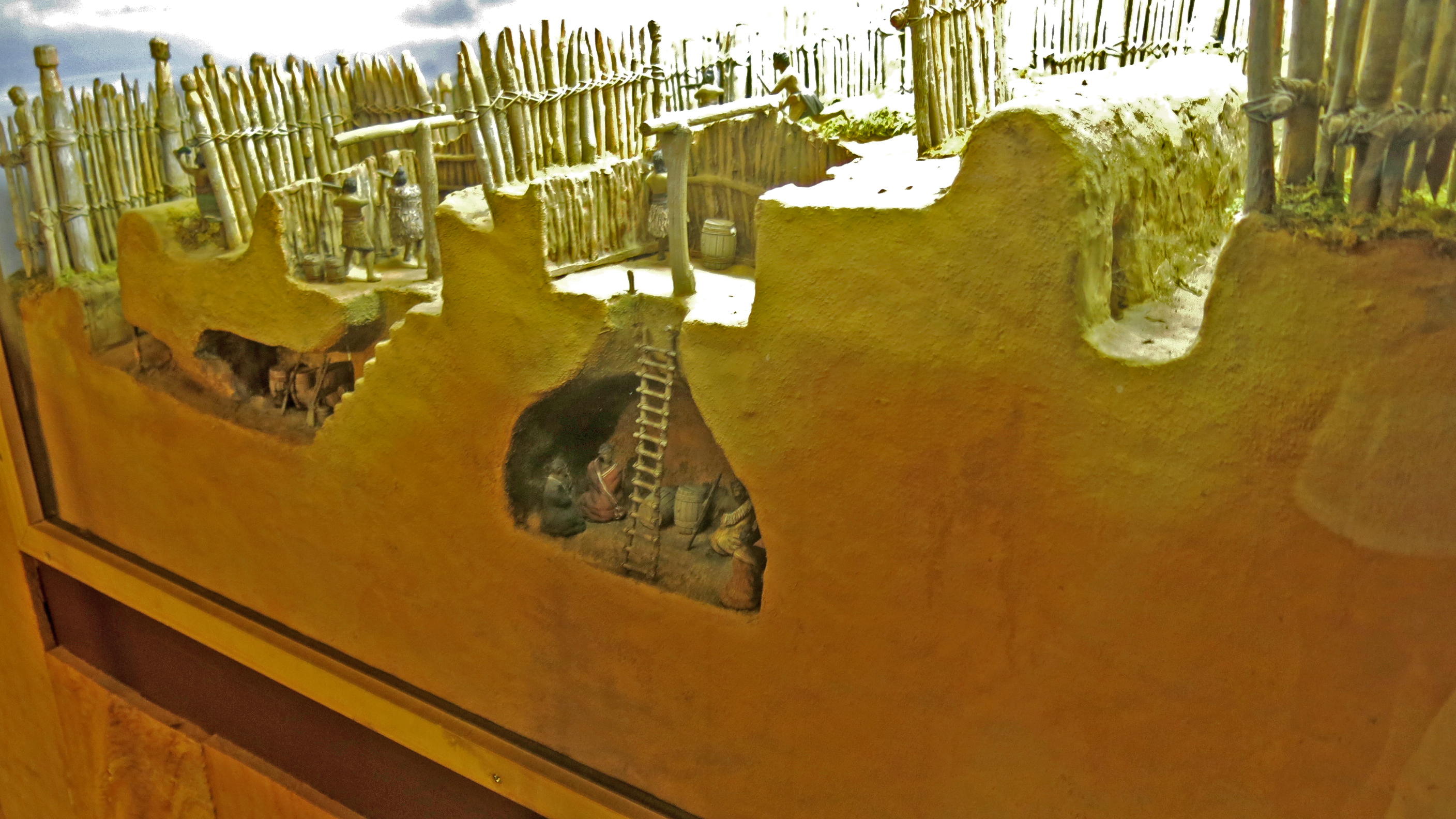
Inside a fort at the time of the Musket Wars. By this time barrels for storage were a normal part of traditional Māori life, and were used not just for powder and shot for the muskets, but for general storage of foods, water and so on.
The pā had to have large supplies of food and water, since a common method of conquering a pā was to starve the inhabitants out.
Later, the underground rooms were expanded in size and number to provide physical protection when the British began bombing the Māori pā.
Photo: Don Hitchcock 2015
Source: Display, Tawhiti Museum
Artist and sculptor: Nigel Ogle
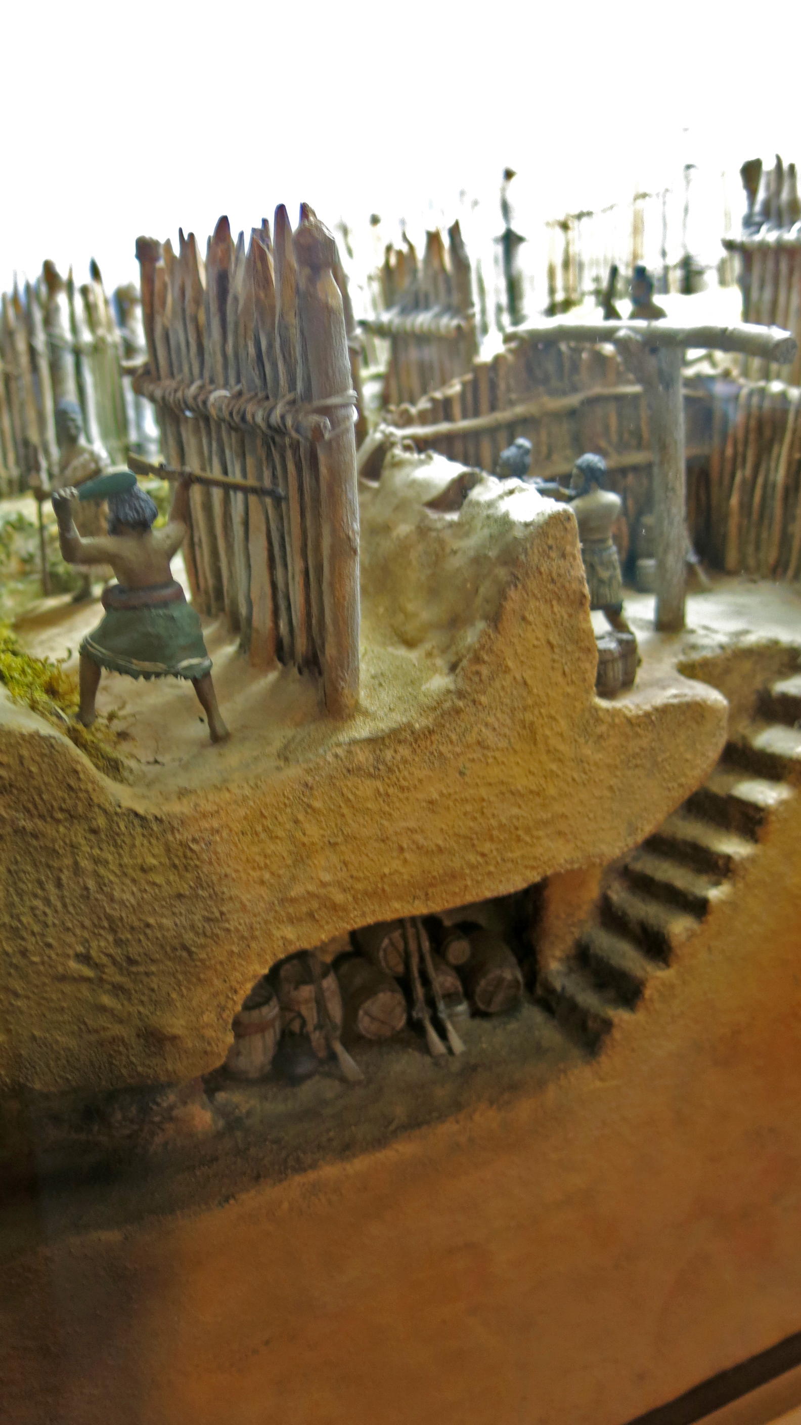
The inner defences, the fall-back positions if the outer walls were breached, were also carefully prepared.
Photo: Don Hitchcock 2015
Source: Display, Tawhiti Museum
Artist and sculptor: Nigel Ogle
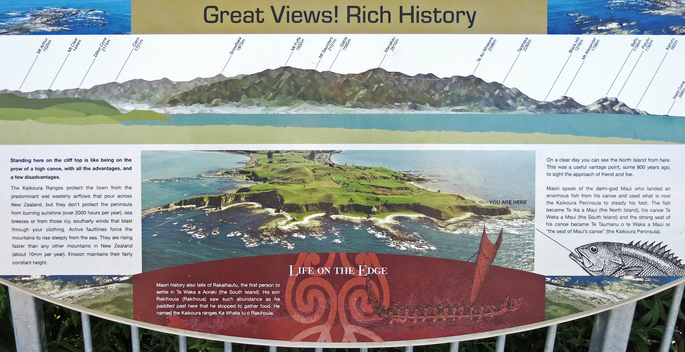
Kaikoura Peninsula Pā sites
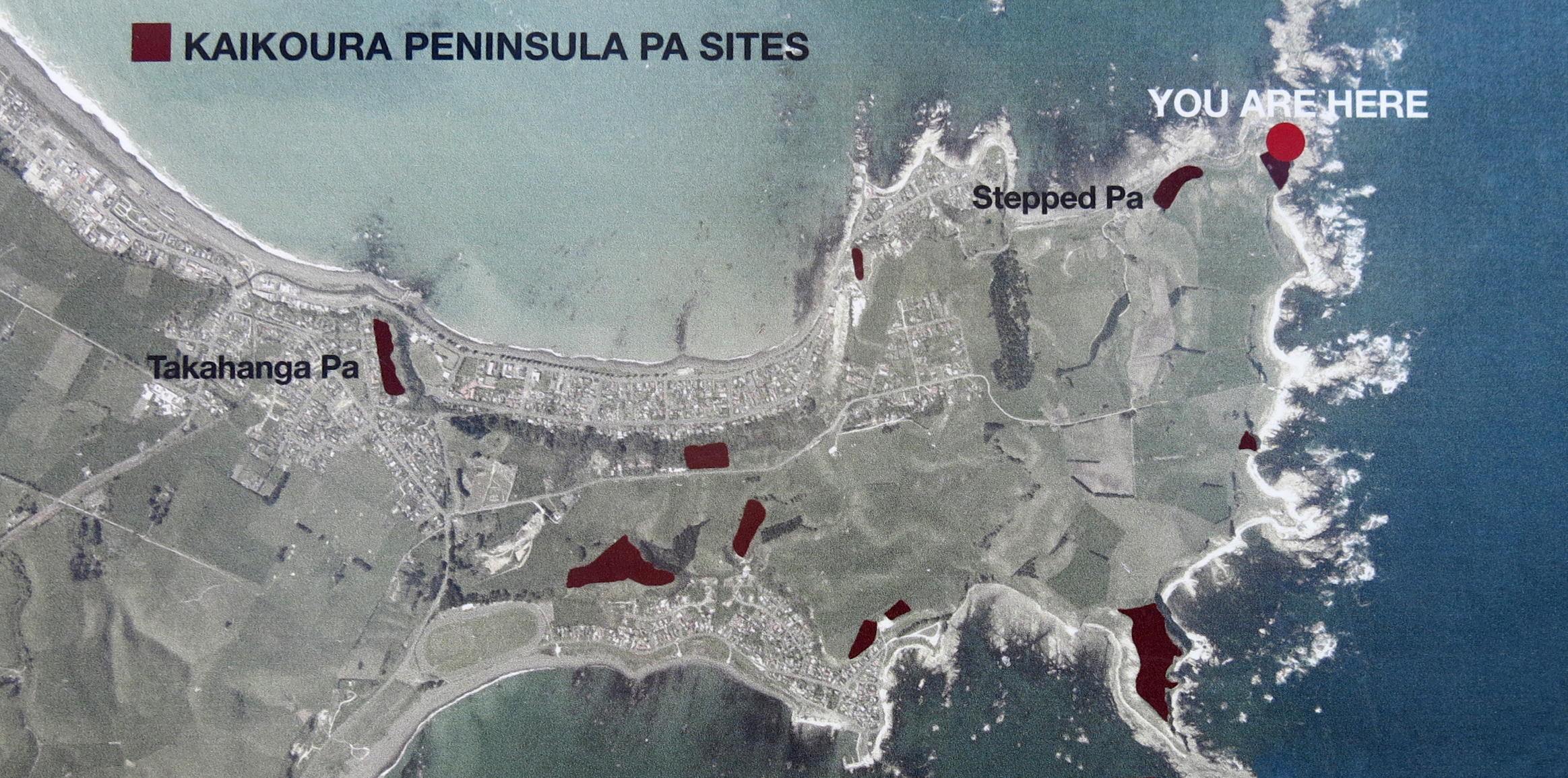
Kaikoura Peninsula Pā sites.
Photo: Don Hitchcock 2013
Original photo: Kevin Jones Department of Conservation
Source: Display, Kaikoura Peninsula
Kaikoura Peninsula Pā site.
Photo: Don Hitchcock 2013
Original photo: Kevin Jones Department of Conservation
Source: Display, Kaikoura Peninsula
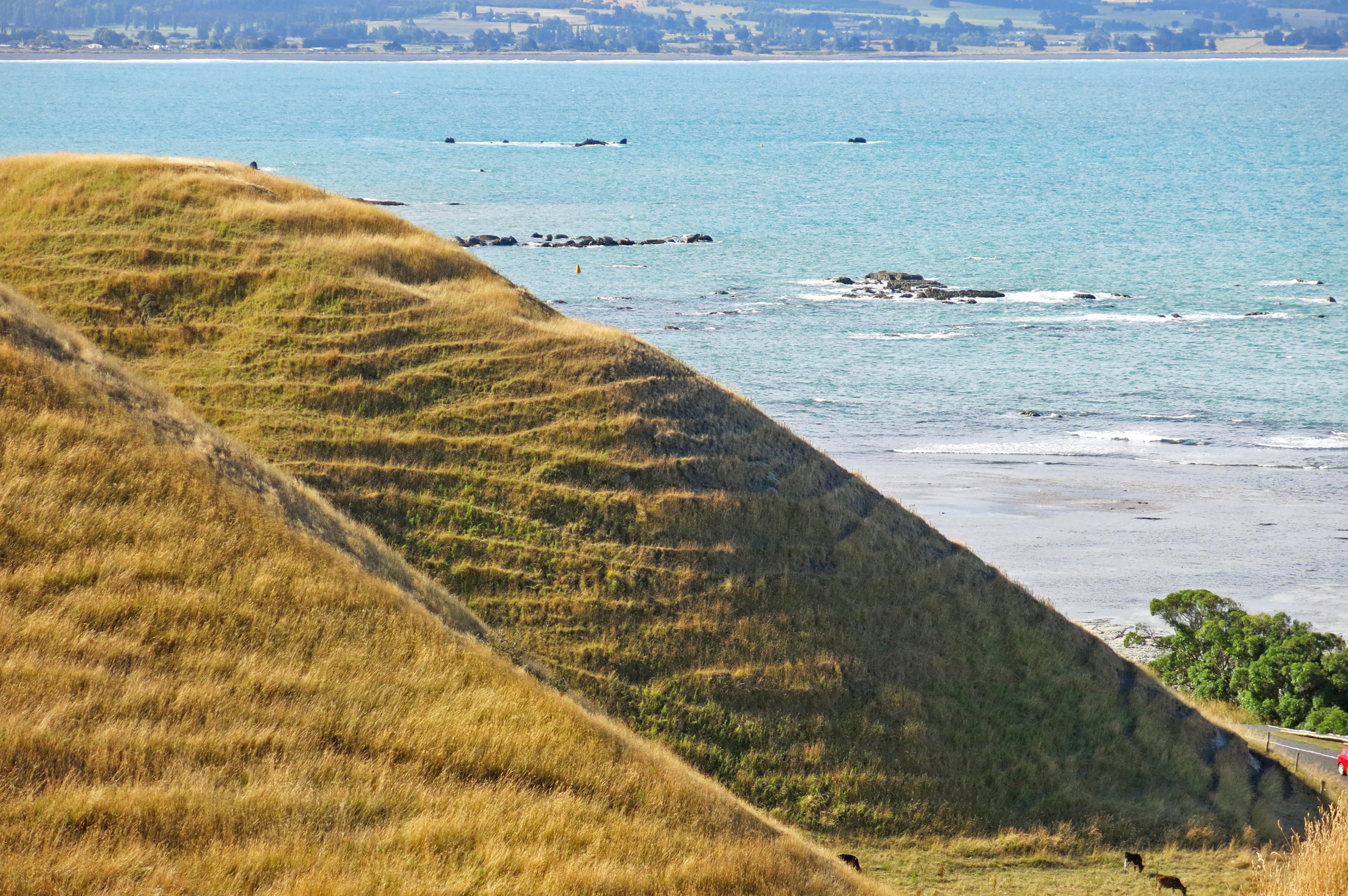
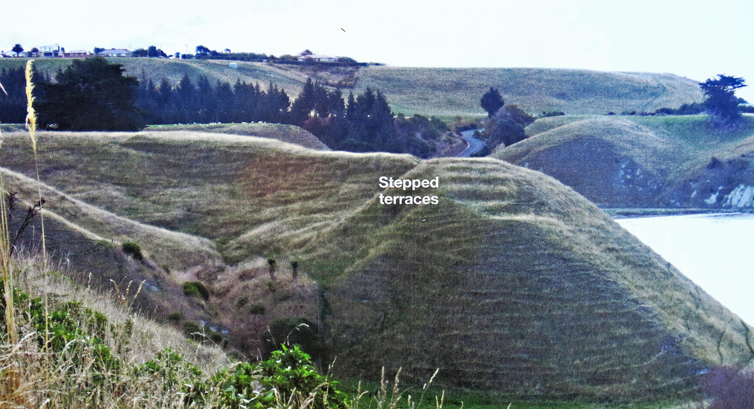
My photo of the remains of the pā. All that can be seen today are the four or five steps cut into the hill.
Photo: Don Hitchcock 2013
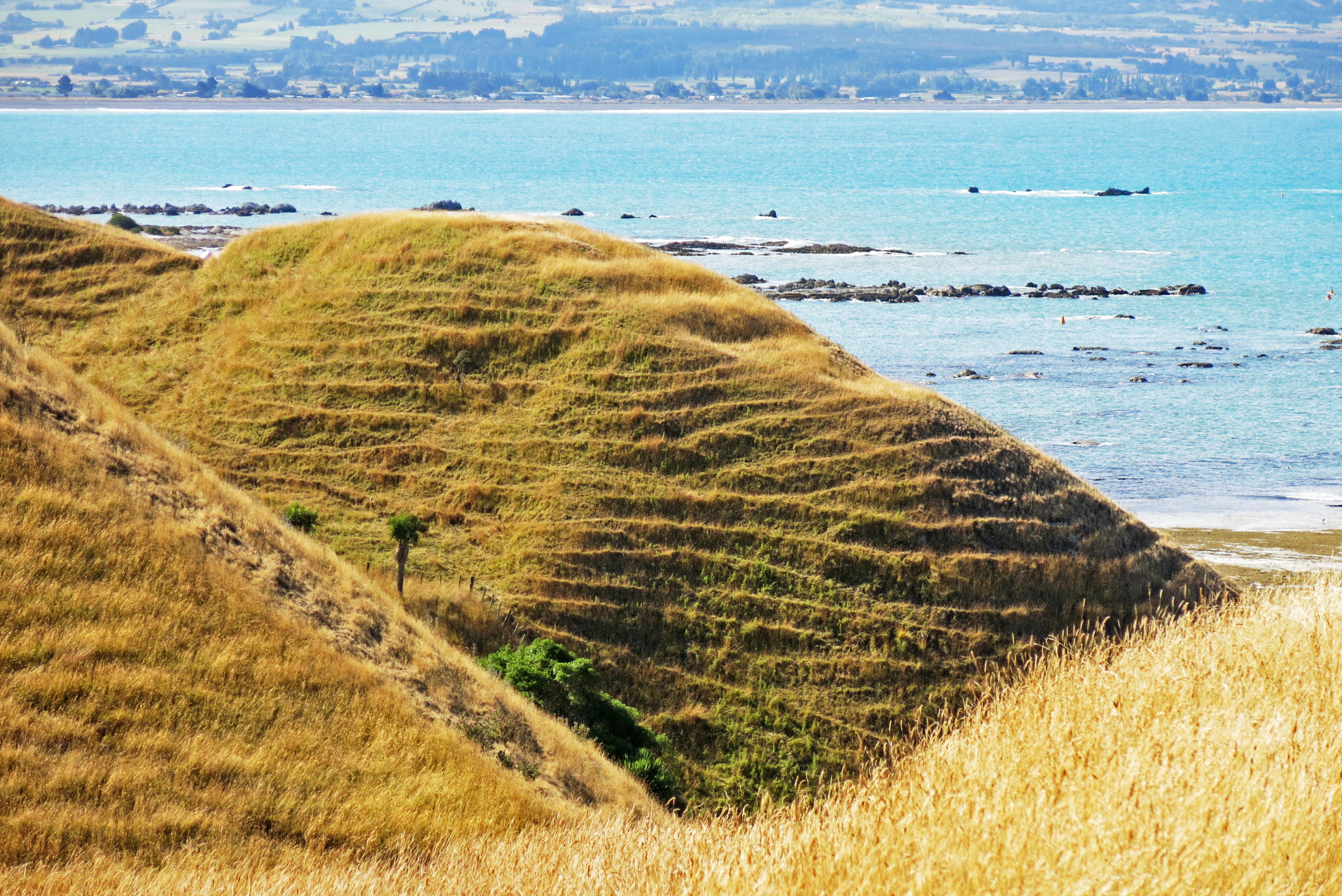
The multitude of smaller approximately horizontal ridges on the hill are sheep trails, a common sight in New Zealand.
Sheep tend to follow each other while grazing, and permanent small ridges develop on such hillsides.
Photo: Don Hitchcock 2013
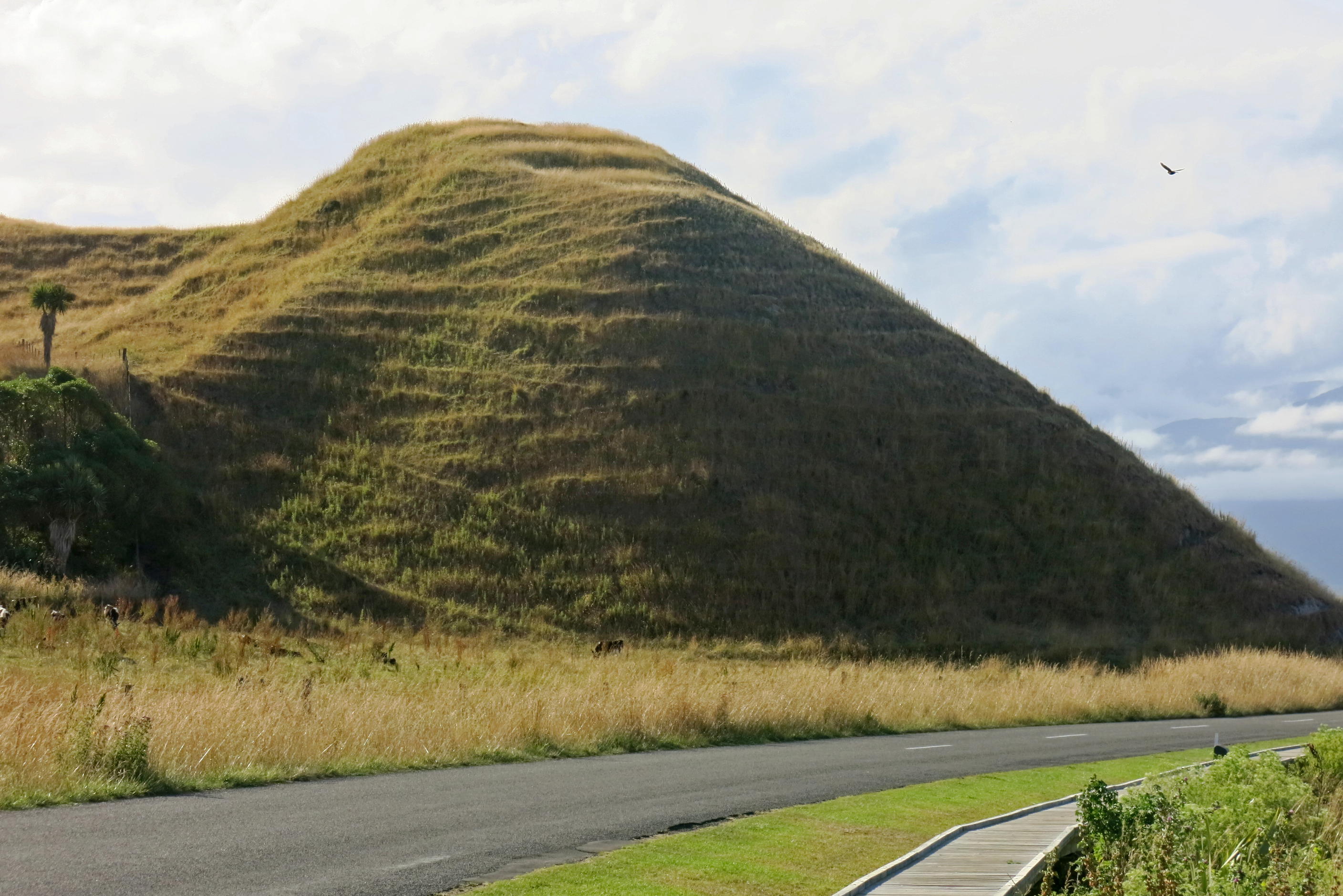
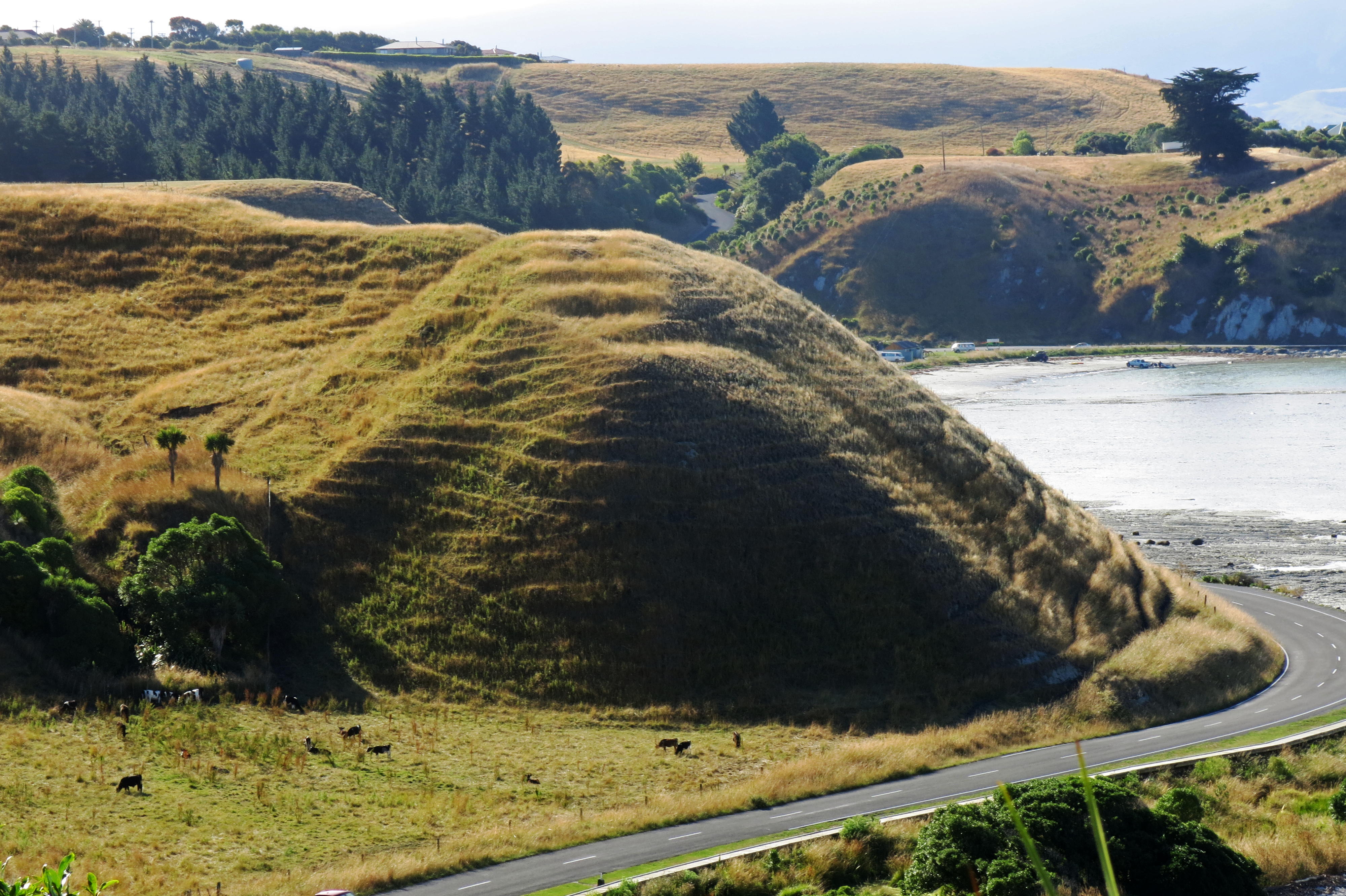
These photographs give some idea of the ideal situation of the pā from the sea aspect.
Attackers climbing the hill, no easy task in itself, would be at serious risk if in a massed formation, simply by the defenders rolling a big rock down the slope. No doubt that had been thought of!
Photo: Don Hitchcock 2013
Kaikoura Peninsula Pā site.
Photo: Don Hitchcock 2013
Original photo: Kevin Jones Department of Conservation
Source: Display, Kaikoura Peninsula

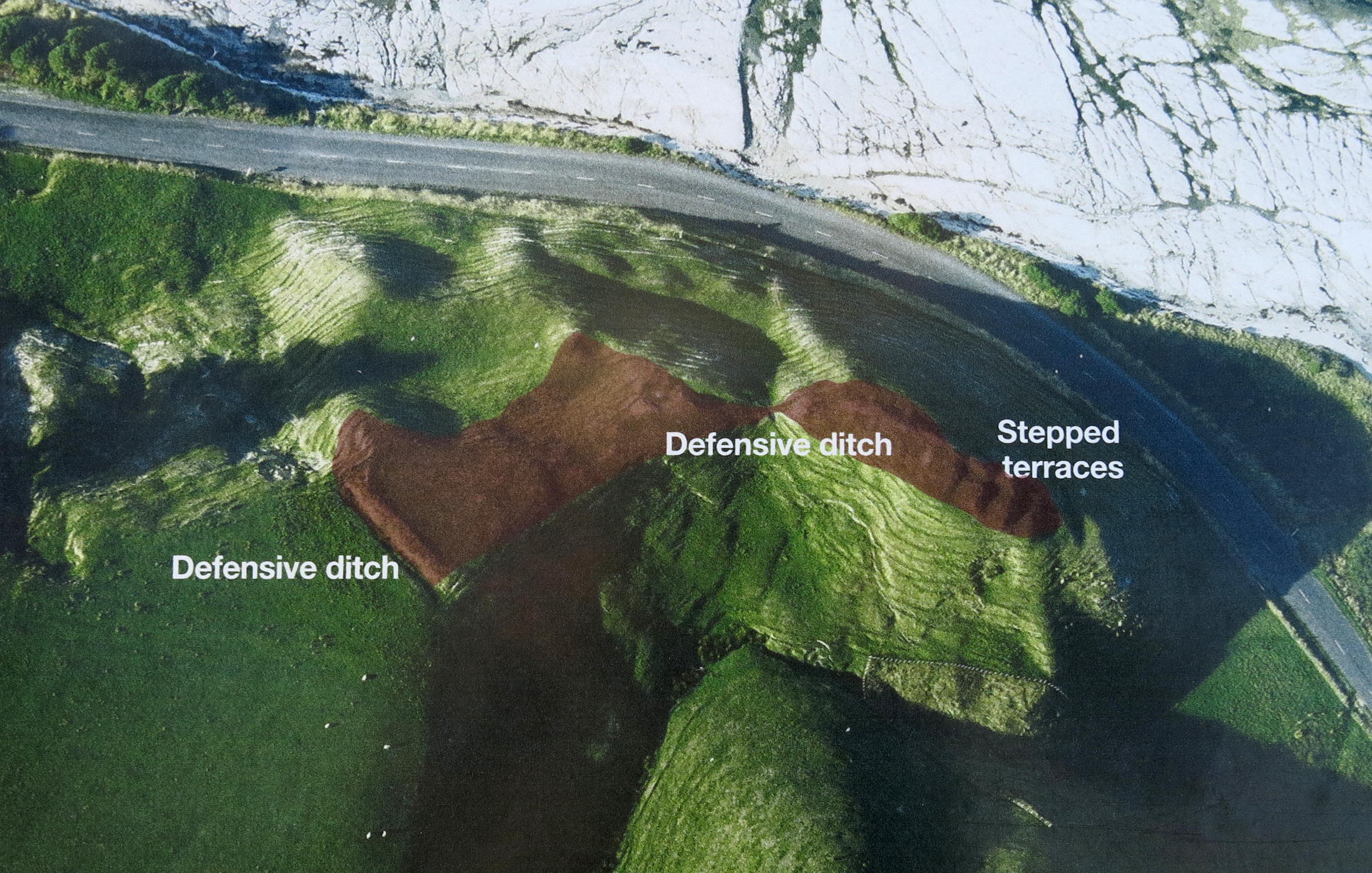
Aerial view of the position of the view point of the Kaikoura Peninsula Pā site.
The view point itself was once the site of a huge pā.
In these photos, pā sites are coloured in brown.
Photo: Don Hitchcock 2013
Original photo: Kevin Jones Department of Conservation
Source: Display, Kaikoura Peninsula
Construction details of typical defensive walls.
Photo: Don Hitchcock 2013
Original photo: Kevin Jones Department of Conservation
Source: Display, Kaikoura Peninsula
Display board at the viewing point.
Photo: Don Hitchcock 2013
Original photo: Kevin Jones Department of Conservation
Source: Display, Kaikoura Peninsula
References
- Cowan J., 1922: The New Zealand Wars: A History of the Maori Campaigns and the Pioneering Period: Volume I (1845–64), New Zealand Government Printer.
- Sole T., 2005: Ngāti Ruanui: A History, Huia Publishers, 1 Jan 2005 506 pp.
Back to Don's Maps
 Back to Archaeological Sites