Back to Don's Maps
 Back to Archaeological Sites
 Back to the review of hominins
Combe Saunière
The site of Combe Saunière was excavated by Geneste and Chadelle between 1978 and 1996. It consists of an ensemble of caves, the principal one containing a long sequence of Middle and Upper Palaeolithic deposits. The cave is situated in an open environment with small valleys and a few low cliffs with habitable caves dispersed along the river edges. Movements of human groups would have been easily possible in all seasons.
The principal locus contains a stratigraphy five metres deep that begins with a sequence of Lower and Upper Wurm deposits (isotopic stages 5 to 2), followed by several Holocene episodes. At the base of the stratigraphy, a sequence of Middle Palaeolithic deposits, dated by ESR to between 100 000 and 60 000 BP, is underlain by a substratum consisting of limestone in some areas and karstic sands in others. This sequence is overlain by Chatelperronian, Aurignacian, Gravettian and Solutrean levels, ending with levels containing a few Magdalenian objects. The radiocarbon dates of these levels extend from 38 000 to 14 000 BP.
The Solutrean levels are dated to approximately 19 000 BP. The sedimentary sequence containing Solutrean artefacts consists of three levels of variable thickness. The basal level (IVc) is 5–30 cm thick and is greatly disturbed by human activities. In some locations it fills in depressions in the directly underlying Gravettian level. It is overlain by a second level (IVb), 10–50 cm thick, and a third thinner level that is more significantly disturbed (IVa).
Text above adapted from Castel et al. (2002)
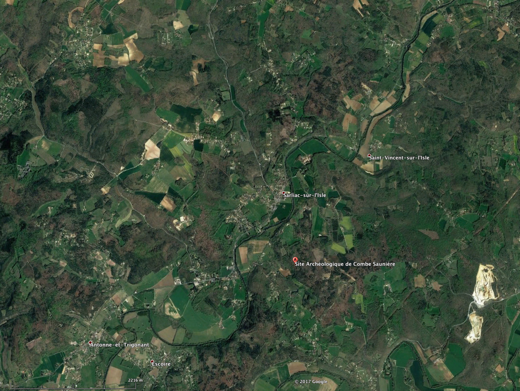
Combe Saunière, 45.225922° N, 0.877655° E, elevation 168 metres.
Photo: Google Maps
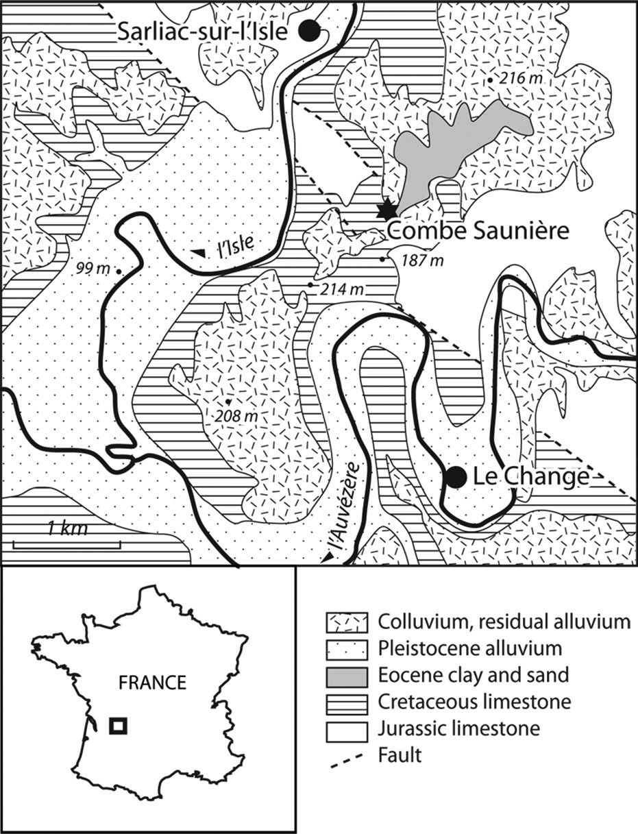
Geology of the region within 3 or 4 kilometres of Combe Saunière.
Photo: Le Pochat et al. (1979) in Ajas et al. (2013)
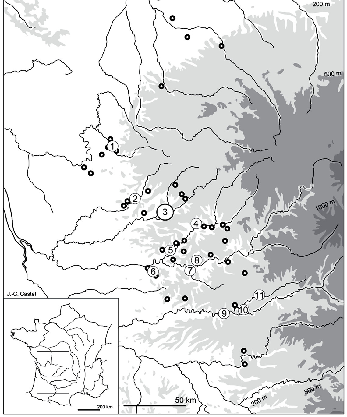
Location of Combe Saunière, No. 3 on this map of Solutrean sites in Southwest France.
Location of Solutrean sites in Southwest France (black circles). Numbers 1-11 are sites with well preserved
faunas: 1 Le Placard; 2 Le Fourneau-du-Diable; 3 Combe Saunière; 4 Badegoule; 5 Laugerie-Haute; 6 Les Jamblancs;
7 Grotte XVI à Cénac; 8 Pech de la Boissière; 9 Le Cuzoul de Vers; 10 Les Peyrugues; 11 Sainte-Eulalie.
Photo and text: Castel et al. (2002)
| Combe Saunière Fauna from the Solutrean | ||
|---|---|---|
| Species | Number of Identified Specimens | Minimum Number of Individuals |
| Reindeer ( Rangifer tarandus ) | 4998 | 40 |
| Horse ( Equus caballus ) | 513 | 7 |
| Bovines ( Bos or Bison ) | 92 | 2 |
| Chamois ( Rupicapra rupicapra ) | 83 | 5 |
| Saiga Antelope ( Saiga tatarica ) | 44 | 3 |
| Red Deer ( Cervus elaphus ) | 43 | 4 |
| Steppe Ass ( Equus hydruntinus ) | 4 | 1 |
| Ibex ( Capra ibex ) | 3 | 1 |
| Boar ( Sus scrofa ) | 1 | 1 |
| Hare ( Lepus sp. ) | 303 | 12 |
| Ground Squirrel ( Citellus sp. ) | 171 | 14 |
| Rabbit ( Oryctolagus cuniculus ) | 81 | 5 |
| Mole ( Talpa sp. ) | 11 | 6 |
| Hedgehog ( Erinaceus sp. ) | 1 | 1 |
| Mammoth ( Mammuthus sp. ) | 1 | 1 |
| Fox ( Vulpes vulpes ) | 560 | 18 |
| Wolf ( Canis lupus ) | 52 | 3 |
| Bear ( Ursus sp. ) | 23 | 4 |
| Badger ( Meles meles ) | 17 | 2 |
| Mustelid ( Martes or Mustela sp. ) | 8 | 2 |
| Hyena ( Crocuta spelaea ) | 2 | 1 |
| Goosander ( Mergus merganster ) | 19 | 3 |
| cf. Goosander ( Mergus cf. merganster ) | 7 | 1 |
| Kestrel ( Falco tinnunculus ) | 7 | 2 |
| cf. Kestrel ( Falco cf. tinnunculus ) | 4 | 1 |
| Ptarmigan ( Lagopus lagopus ) | 9 | 1 |
| Raven ( Corvus corax ) | 9 | 2 |
| cf. Peregrine ( Falco cf. peregrinus ) | 6 | 2 |
| Grey Partridge ( Perdix perdix ) | 4 | 3 |
| Goose ( Anser sp. ) | 3 | 2 |
| Jackdaw ( Corvus monedula ) | 3 | 2 |
| Little Owl ( Athena noctua ) | 2 | 1 |
| Diving Duck ( Aythia sp. ) | 1 | 1 |
| Chough ( Pyrrhocorax graculus ) | 1 | 1 |
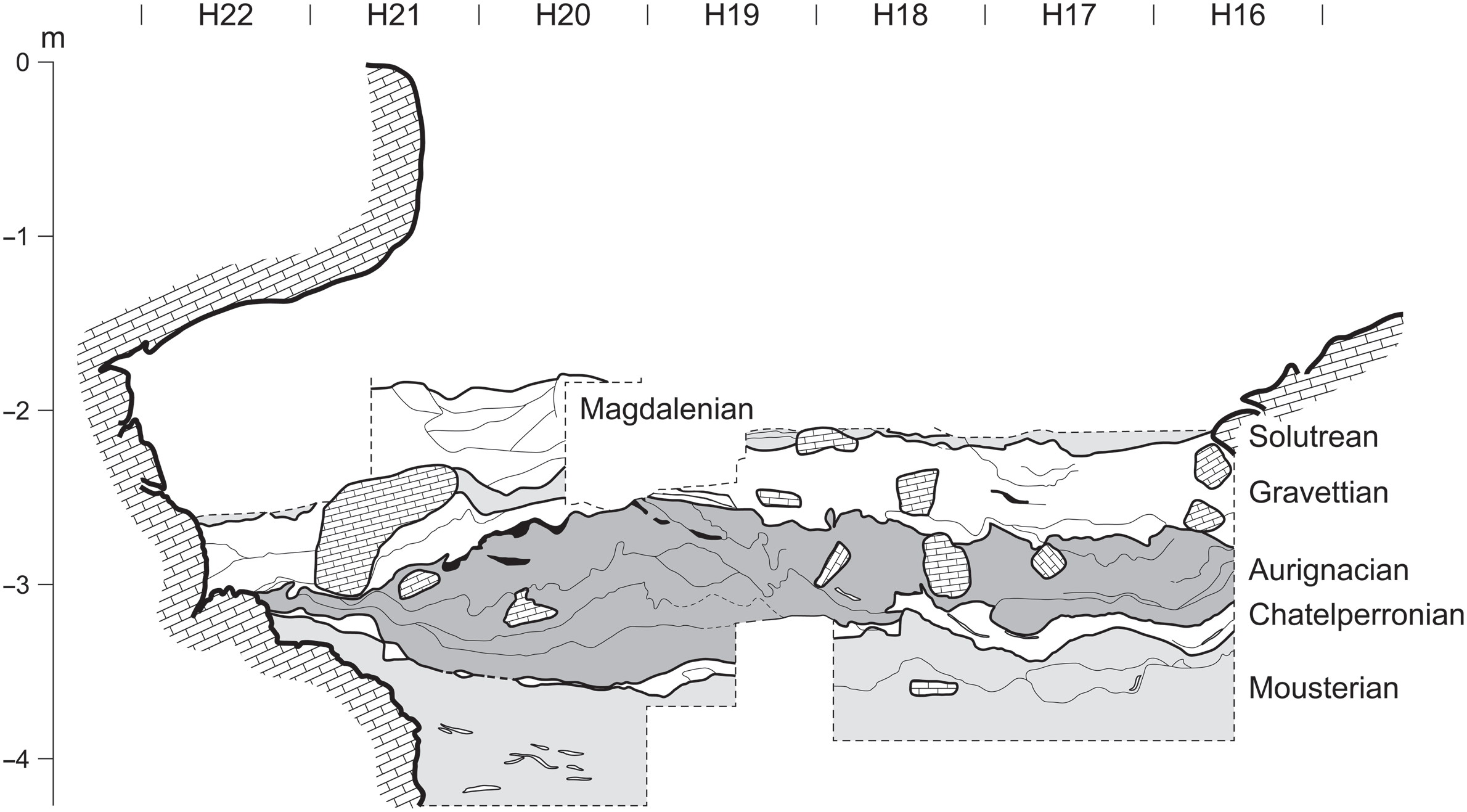
The stratigraphy of Combe Saunière.
Bronze Age and historic layers omitted for clarity.
Photo: Cosgrove, Geneste and Castel (2013)
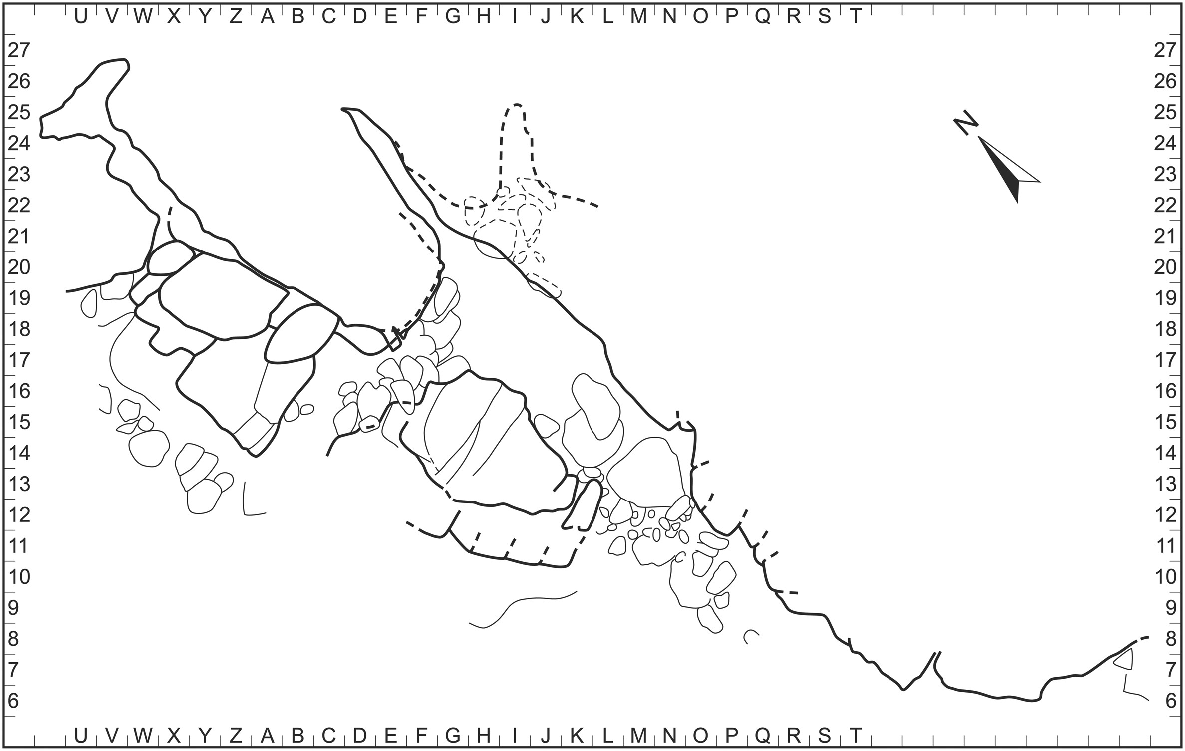
Plan of Combe Saunière.
Photo: Cosgrove, Geneste and Castel (2013)
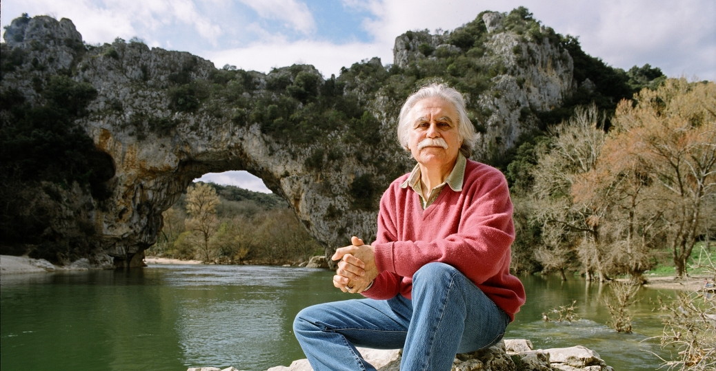
Jean-Michel Geneste, one of France's foremost archaeologists and an expert on Rock Art, on the set of 'Cave of Forgotten Dreams'.
Curator then research director of the cave of Lascaux, he has been for more than two decades attached to the archaeological study of decorated caves. He has directed the multidisciplinary study program at the Chauvet-Pont d'Arc cave since 2002.
He has coordinated archaeological research programs in France, Ukraine, South Africa, Papua New Guinea and currently in Arnhem Land, Australia. He has edited books on the Palaeolithic and Rock Art and has published a large number of articles.
Jean-Michel Geneste went to Chauvet cave to study the archaeological remains including the lithic and bone industries and their distribution at the site, whose analyses he coordinated with the researchers involved, leading to the determination of the supply territories used by groups occupying the cave.
Photo: history.com, via Stella Tsank, https://www.pinterest.com.au/source/history.com/
Text: Translated and adapted from http://archeologie.culture.fr/chauvet/fr/auteur/jean-michel-geneste
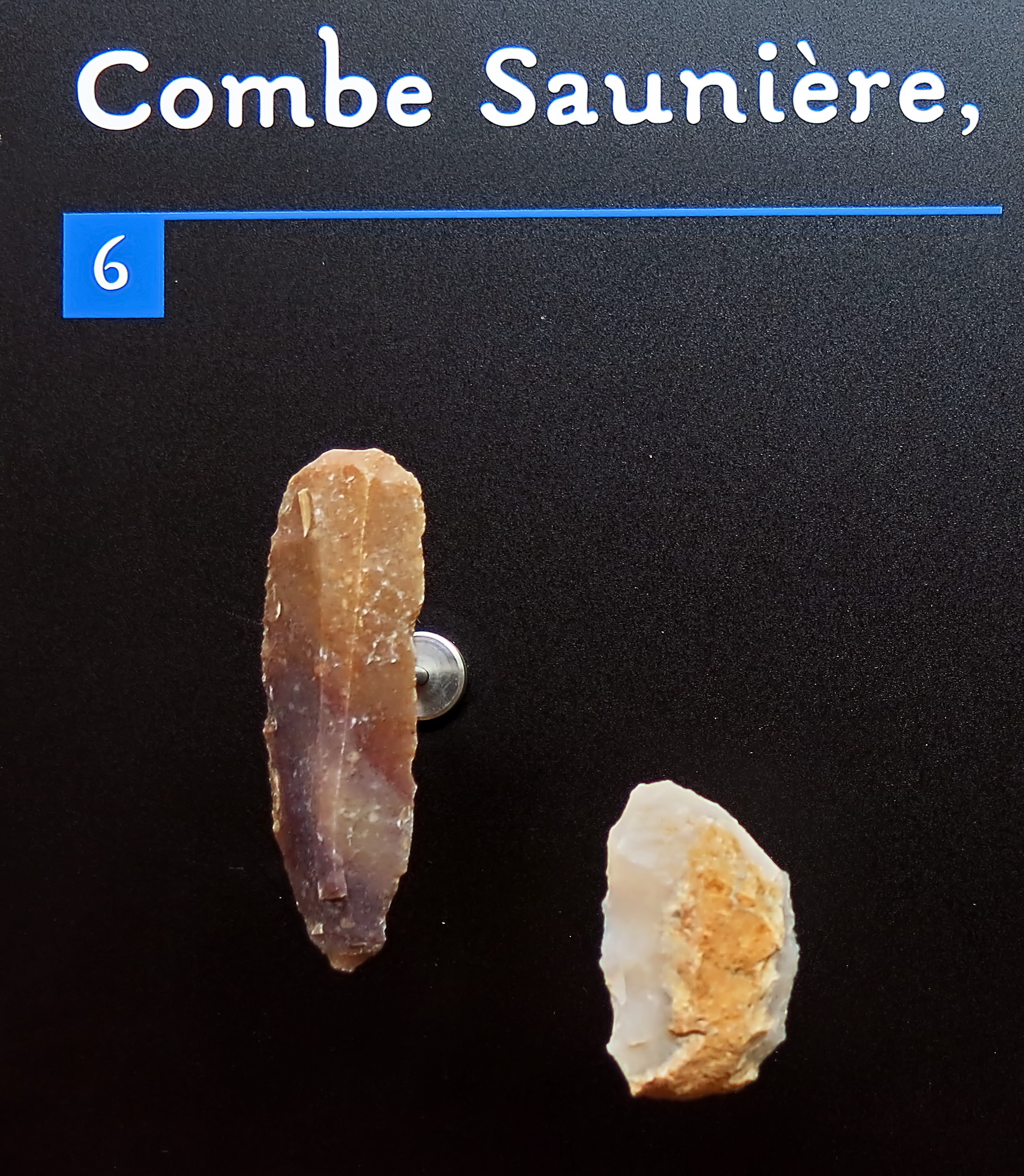
Combe Saunière, layer 4, excavations of J.-M. Geneste.
Age: Solutrian, circa 19 000 BP.
■ 6: Grattoirs, scrapers on the end of a blade
Photo: Don Hitchcock 2014
Source: Originals, Le Musée National de Préhistoire, Les Eyzies-de-Tayac
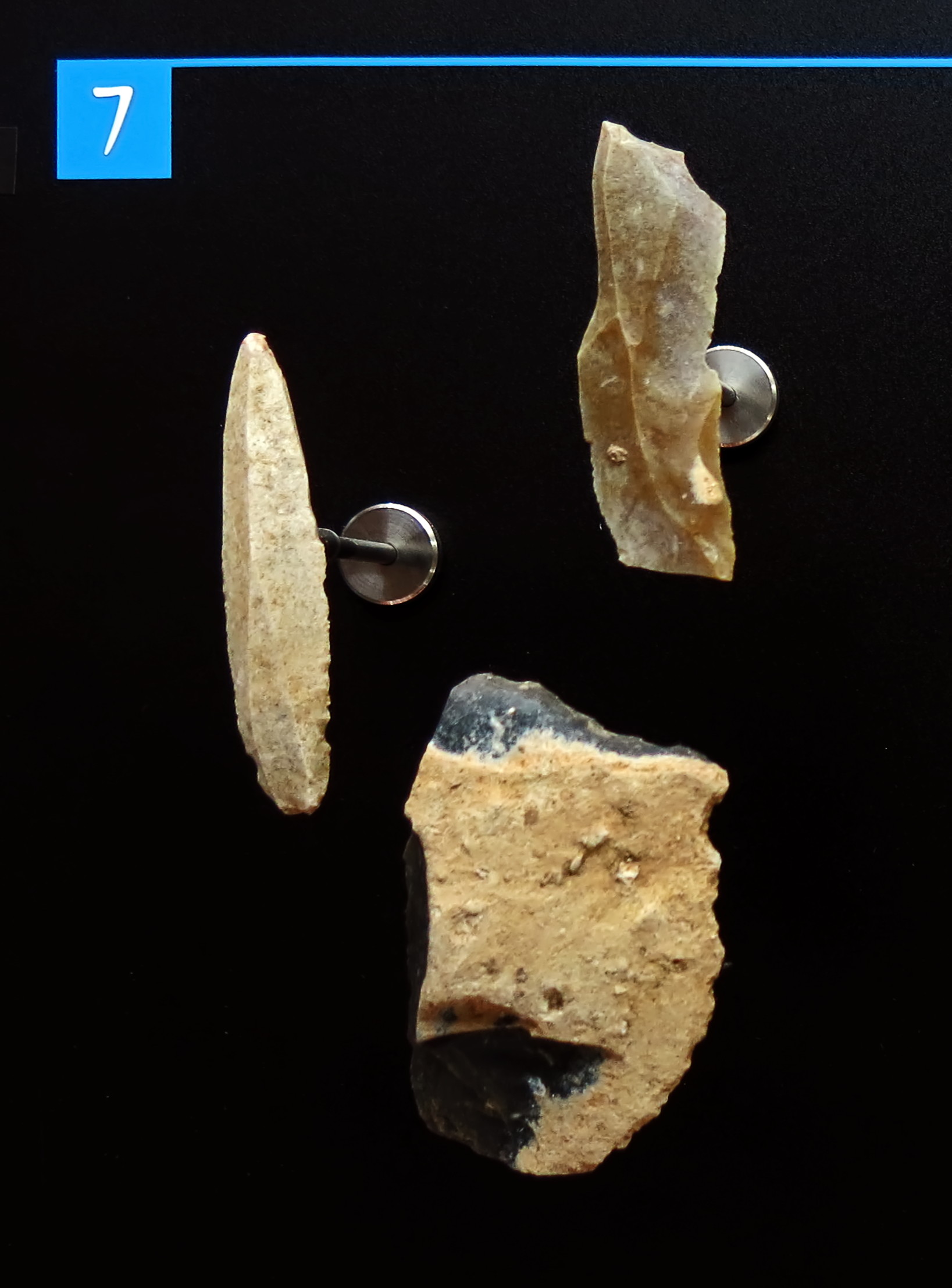
Combe Saunière, layer 4, excavations of J.-M. Geneste.
Age: Solutrian, circa 19 000 BP.
■ 7: Burins
Photo: Don Hitchcock 2014
Source: Originals, Le Musée National de Préhistoire, Les Eyzies-de-Tayac
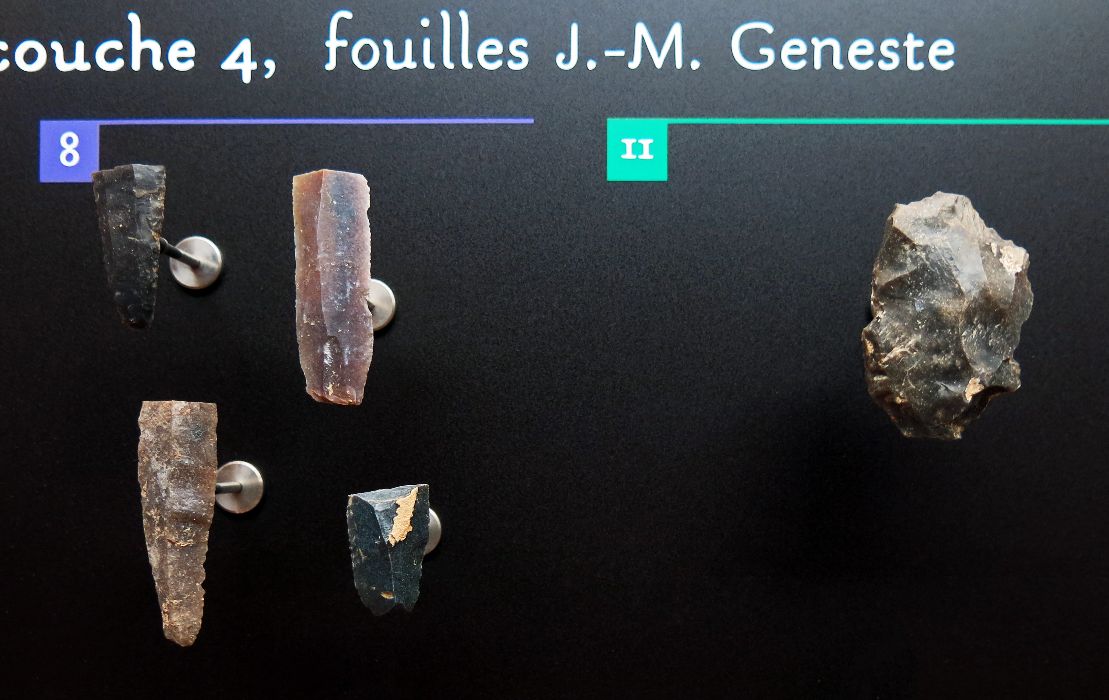
Combe Saunière, layer 4, excavations of J.-M. Geneste.
Age: Solutrian, circa 19 000 BP.
■ 8: Retouched tools
■ 11: Notched/denticulated tools
Photo: Don Hitchcock 2014
Source: Originals, Le Musée National de Préhistoire, Les Eyzies-de-Tayac
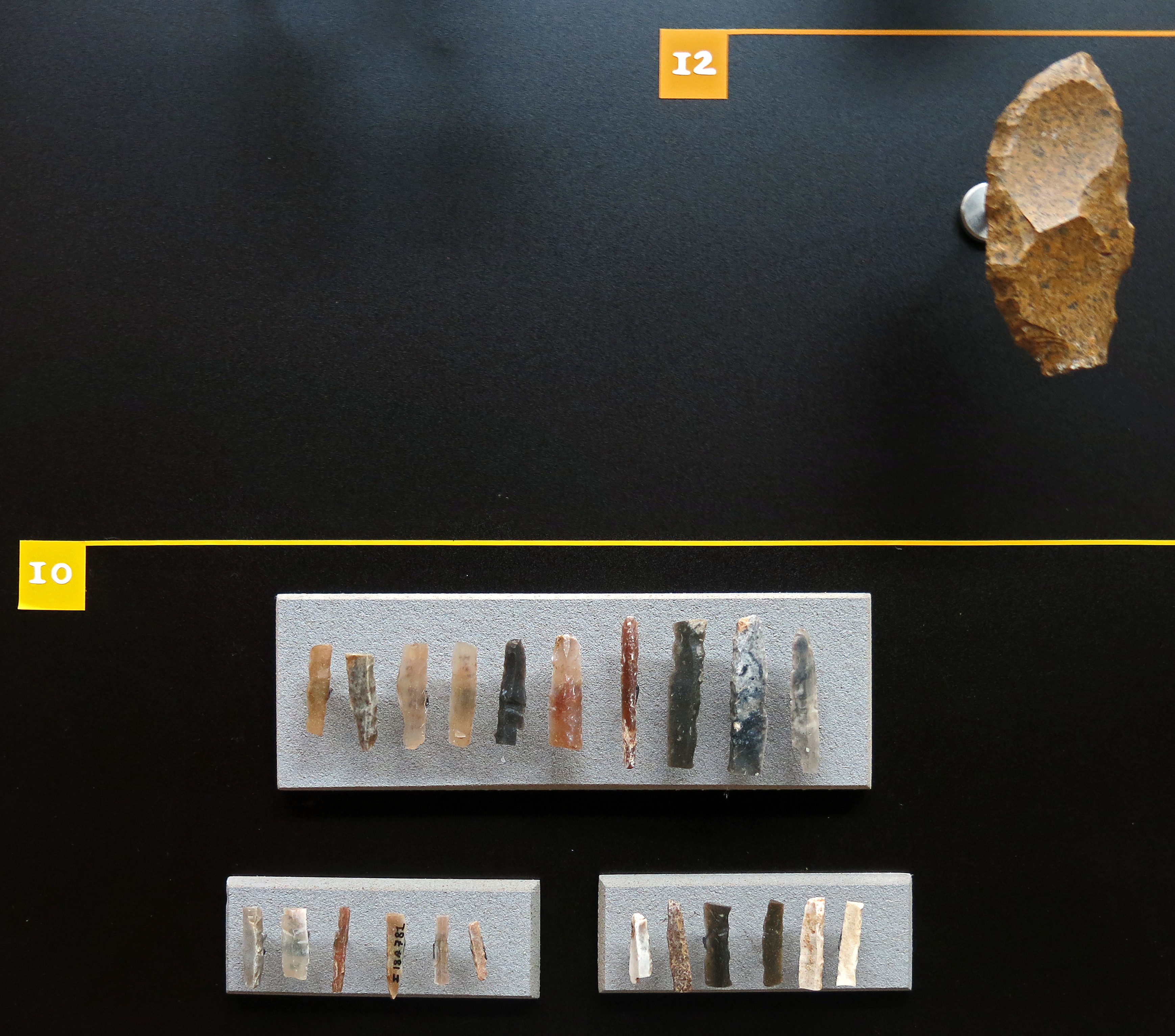
Combe Saunière, layer 4, excavations of J.-M. Geneste.
Age: Solutrian, circa 19 000 BP.
■ 10: Microliths
■ 12: Racloirs/raclettes, side scrapers and small, often round scrapers
Photo: Don Hitchcock 2014
Source: Originals, Le Musée National de Préhistoire, Les Eyzies-de-Tayac
Combe Saunière, layer 4, excavations of J.-M. Geneste.
Age: Solutrian, circa 19 000 BP.
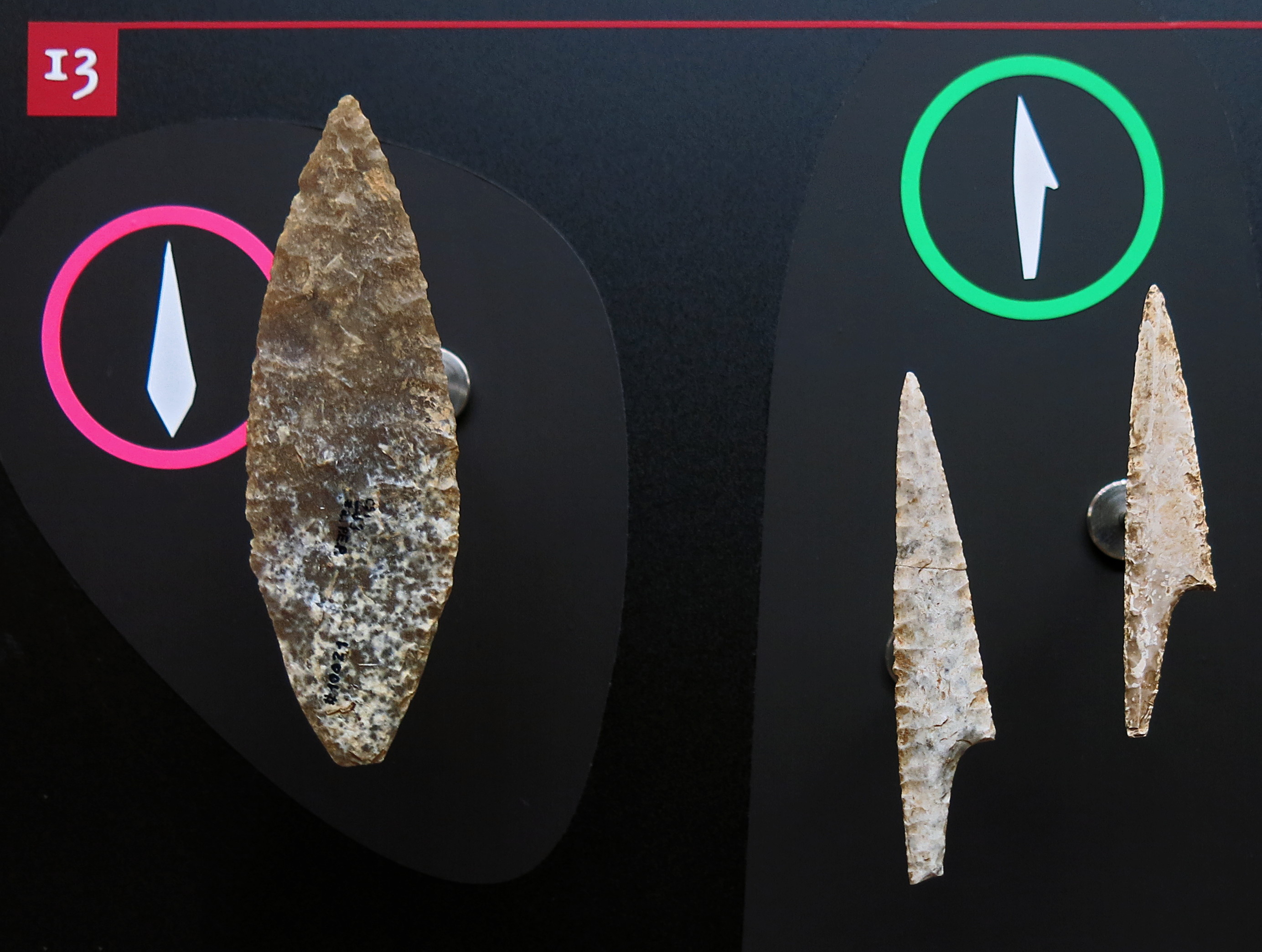
■ 13: Armatures, tools
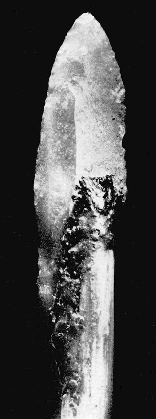
( On the left is a classic Solutrean laurel leaf point, with shouldered points on the right.
A shouldered point, kerfspits or pointe à cran is a projectile or blade that has a stem which was designed for hafting on a shaft or handle - Don )
Photo: Don Hitchcock 2014
Source: Originals, Le Musée National de Préhistoire, Les Eyzies-de-Tayac
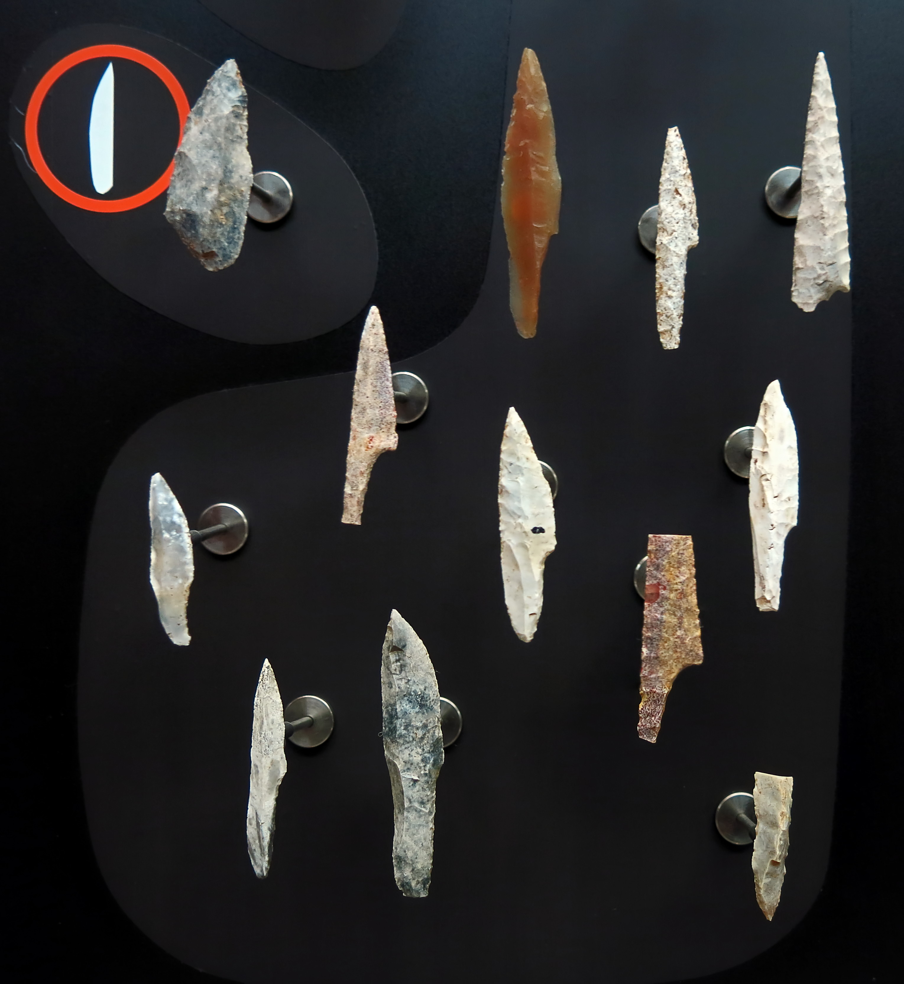
Combe Saunière, layer 4, excavations of J.-M. Geneste.
Age: Solutrian, circa 19 000 BP.
■ 13: Armatures, tools
( Shouldered points quite often came back from the hunt broken, but still attached to the valuable shafts, and were discarded at the living area when a new point was attached to the undamaged or repaired shaft. Thus they appear quite often in the archaeological record. An example in this image is the broken, pink/yellow flint shouldered point on the lower right, a beautiful piece in every way, from the flint used to the elegant shape to the superb pressure flaking. It must have been disappointing for the hunter to have it break - Don )
Photo: Don Hitchcock 2014
Source: Originals, Le Musée National de Préhistoire, Les Eyzies-de-Tayac
Combe Saunière, layer 4, excavations of J.-M. Geneste.
Age: Solutrian, circa 19 000 BP.
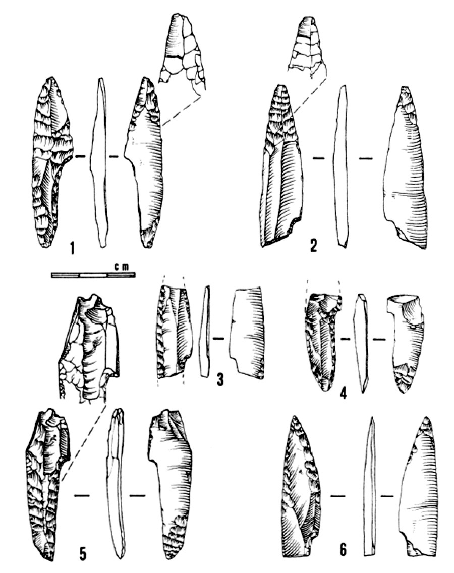
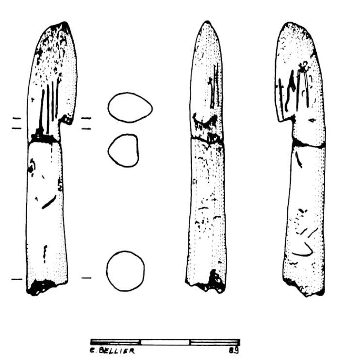
Solutrean pointes à cran from layer 4, with characteristic flake scars and impact striations.
Photo and text: Geneste et Plisson (1986)
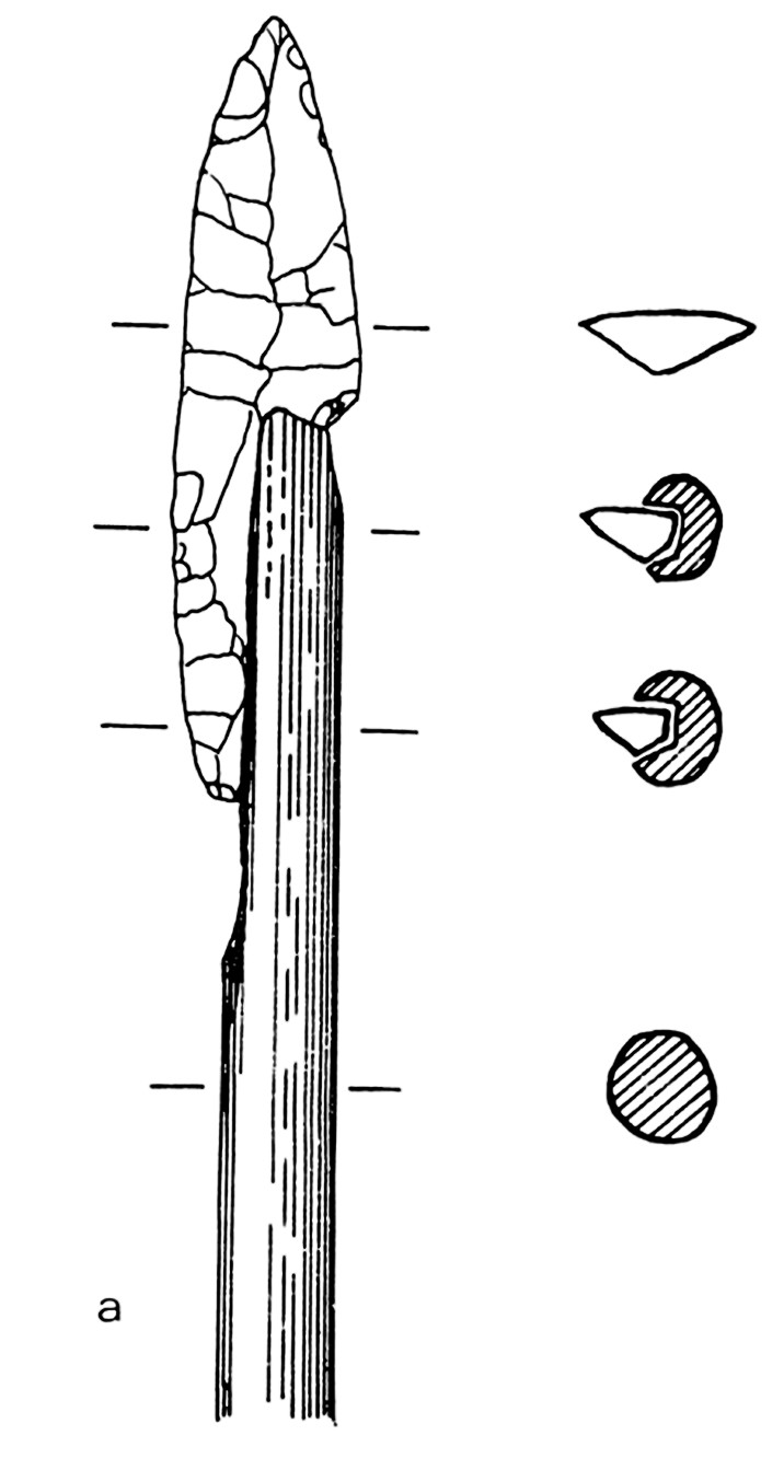
Method of attachment of a pointe à cran.
Putting a groove in the shaft of the dart and gluing the pointe à cran to the shaft using pine resin took about fifteen minutes work.
Photo and text: Geneste et Plisson (1986)
Combe Saunière, layer 4, excavations of J.-M. Geneste.
Age: Solutrian, circa 19 000 BP.
■ 14: Composite tools
■ 15: Special tools
Photo: Don Hitchcock 2014
Source: Originals, Le Musée National de Préhistoire, Les Eyzies-de-Tayac
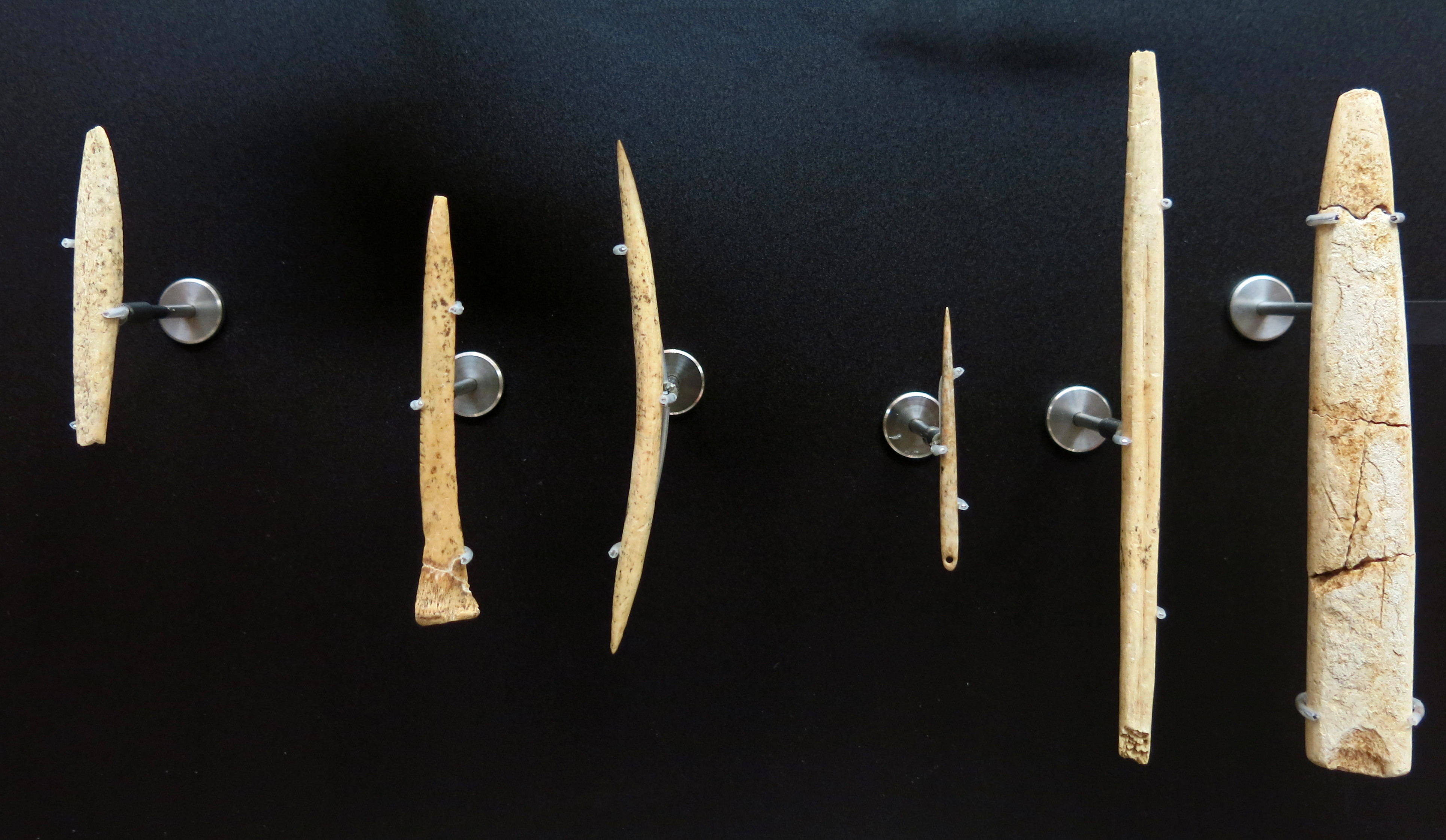
Combe Saunière, layer 4, excavations of J.-M. Geneste.
Age: Solutrian, circa 19 000 BP.
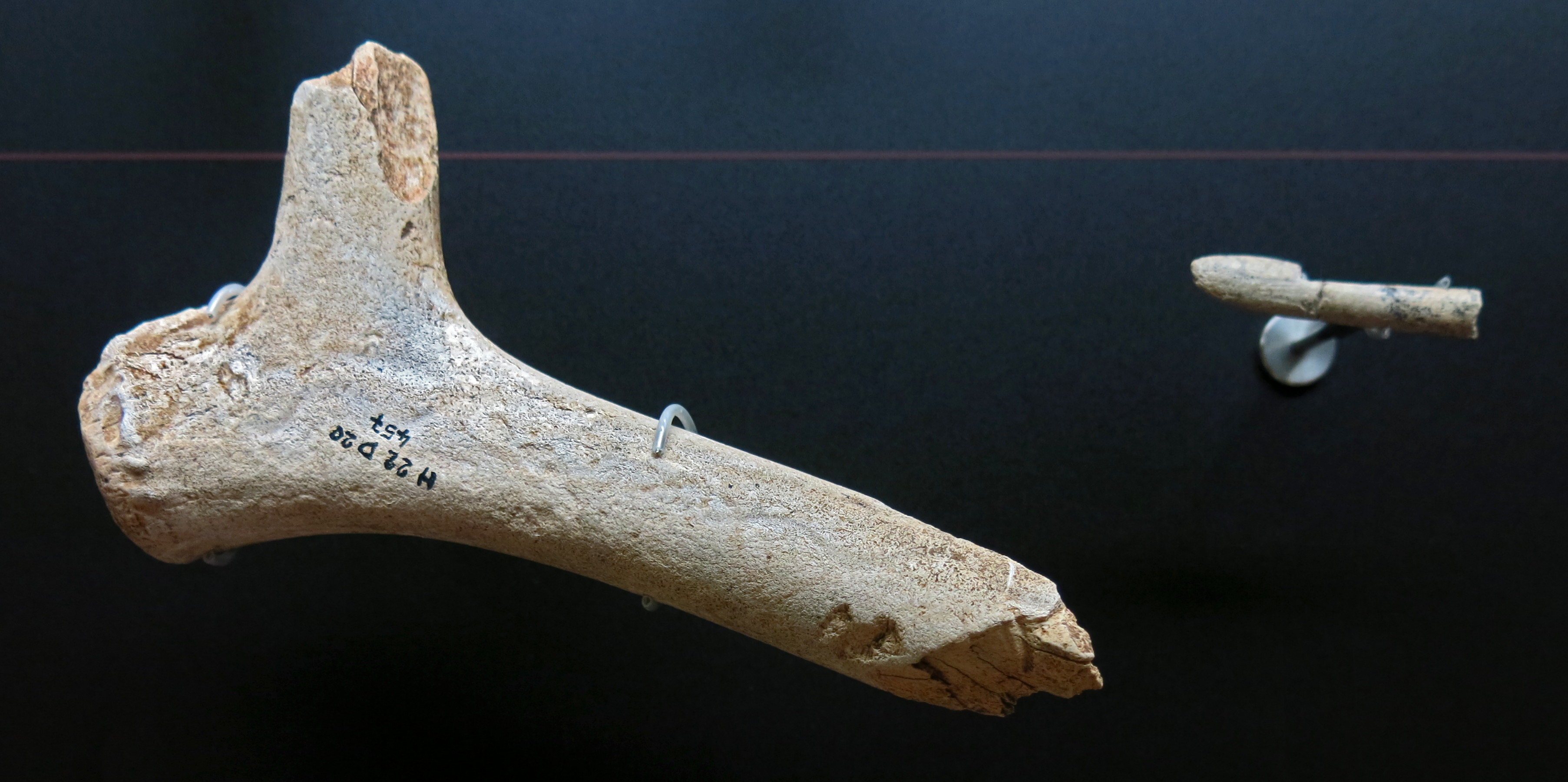
■ 16: Bone industry
On the left is a piece of reindeer antler, possibly with shallow engraving, on the right a crochet or hook from a propulseur, or spear thrower, the earliest such example extant.
Photo: Don Hitchcock 2014
Source: Originals, Le Musée National de Préhistoire, Les Eyzies-de-Tayac
Combe Saunière, layer 4, excavations of J.-M. Geneste.
Age: Solutrian, circa 19 000 BP.
The oldest known propulseur or spear thrower, dating from the upper Solutrean, and coming from layer 4 of Combe-Saunière.
Text: Rillardon (2010)
Photo: Don Hitchcock 2014
Source: Originals, Le Musée National de Préhistoire, Les Eyzies-de-Tayac
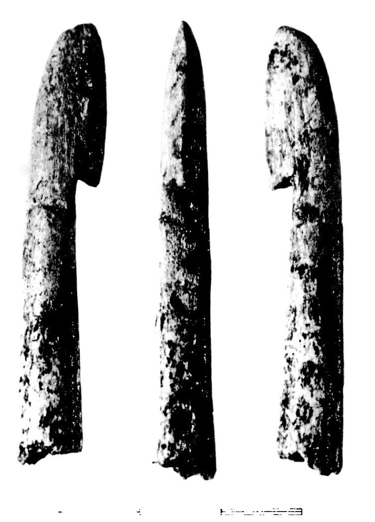
In 1986, a small hook made in reindeer antler was found in the Upper Solutrean level of the Combe-Saunière 1 cave (Dordogne). The morphology and dimensions of the object denote a perfect integration within the series of palaeolithic and precolumbian spearthrowers in antler. It shows a particular similarity with three palaeolithic spearthrowers found in the Placard cave (Charentes) in the XlXth century. Experimental reconstruction demonstrates its efficiency.
Photo and text: Cattelain (1989)
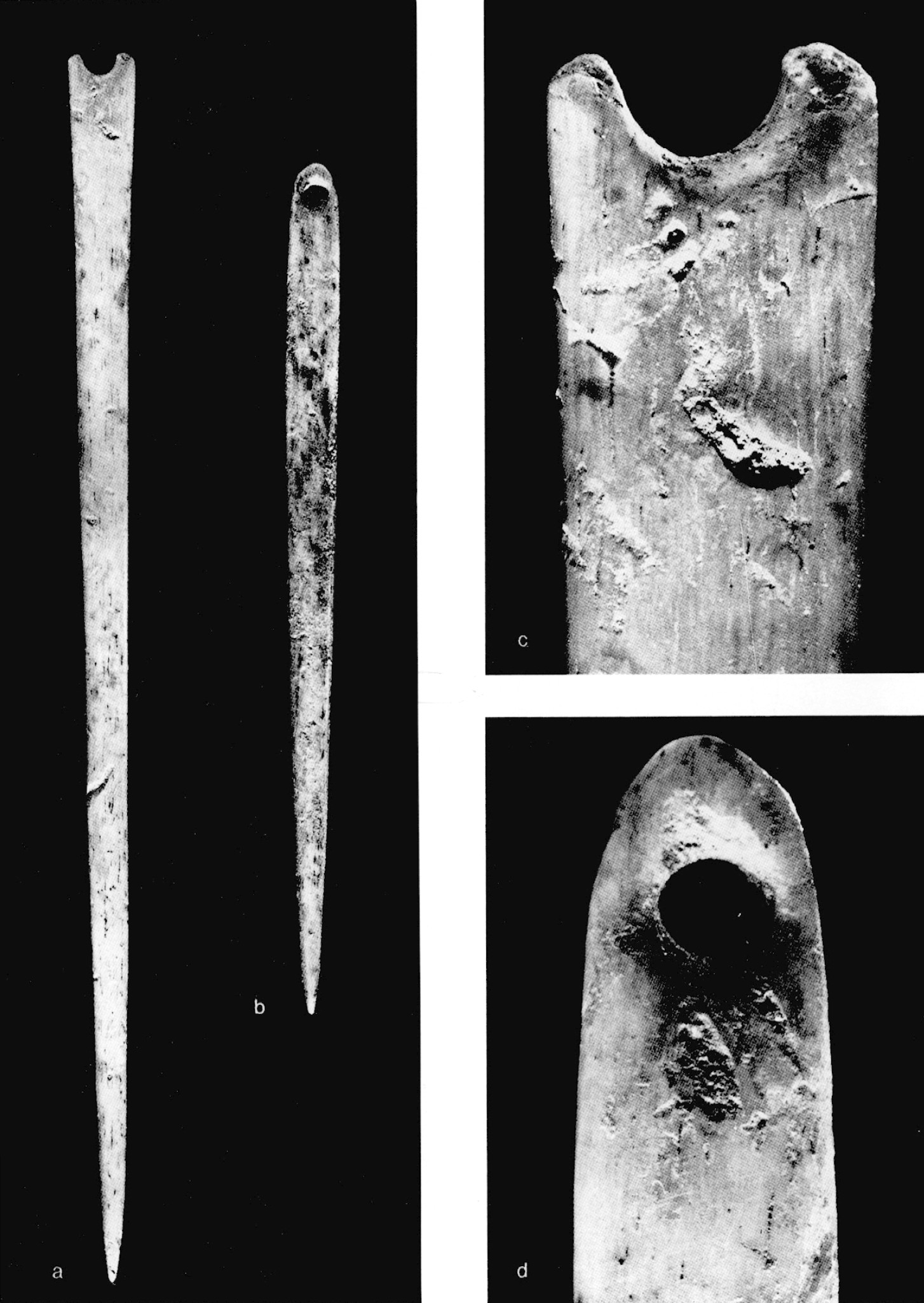
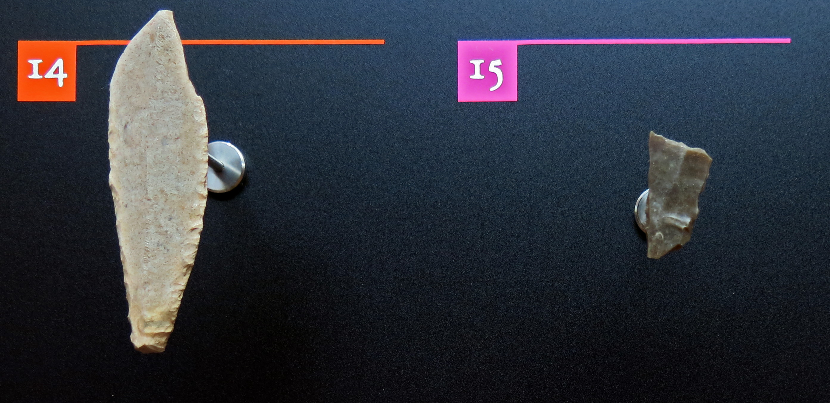
In addition to the abundant representation of spear points (37 examples were found), five needles were found in layer 4, and three of them have an eye, although one is broken.
These latest discoveries, together with those of Laugerie-Haute Est and the Fritsch shelter confirm the appearance of this type of object at the end of the Solutrean.
Photo (left): Geneste et Plisson (1986)
Photo (right): Don Hitchcock 2014
Source: Originals, Le Musée National de Préhistoire, Les Eyzies-de-Tayac
Text: Geneste et Plisson (1986)
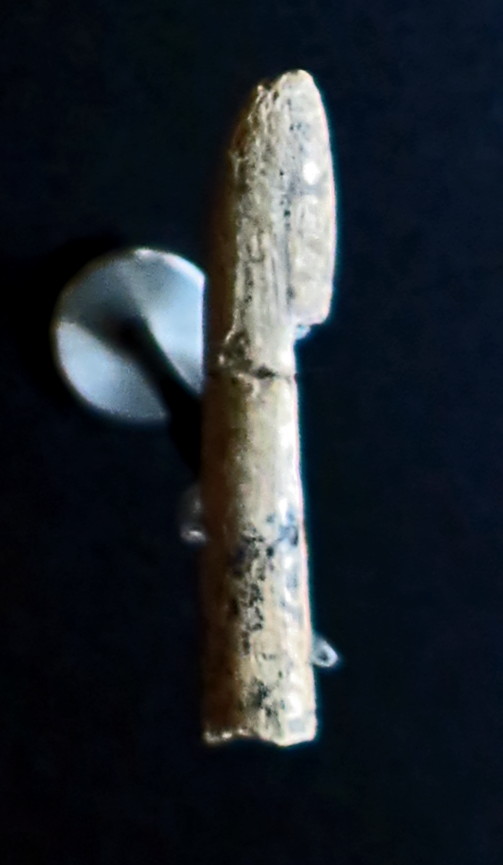
Combe Saunière, layer 4, excavations of J.-M. Geneste.
Age: Solutrian, circa 19 000 BP.
■ 16: Bone industry
( these bone or reindeer antler objects were not identified by the museum as to purpose. From left to right, my identifications are:
Spear point (or possibly a small wedge), awl (with a broken tip, and decorated with notches), double ended projectile point (according to Castel et al. (2002)), eyed needle as described above, projectile point (according to Castel et al. (2002)), bone/antler tool used as a wedge (very similar to one described by Castel et al. (2002)).
- Don )
Photo: Don Hitchcock 2014
Source: Originals, Le Musée National de Préhistoire, Les Eyzies-de-Tayac
References
- Ajas, A., Bertran, P., Lemée, L., Queffelec, A., 2013: Stratigraphy and Palaeopedology of the Palaeolithic Cave Site of Combe-Saunière, Southwest France. , Geoarchaeology, 28(5), 432–449. https://doi.org/10.1002/GEA.21451
- Castel J, Liolios D., Laroulandie V., Chauvière F., Chadelle J., Pike-Tay A., Geneste J., 2002: 17. Solutrean Animal Resource Exploitation at Combe Saunière (Dordogne, France), Integrating Zooarchaeology, ed. Mark Maltby, 9th ICAZ Conference, Durham 2002, pp. 138–152
- Cattelain P., 1989: Un crochet de propulseur solutréen de la grotte de Combe-Saunière 1 (Dordogne), in: Bulletin de la Société préhistorique française, tome 86, no. 7, 1989. pp. 213-216; doi : 10.3406/bspf.1989.9386 http://www.persee.fr/doc/bspf_0249-7638_1989_num_86_7_9386
- Cosgrove R., Geneste J-M., Castel J-C, 2013: Perspectives on Global Comparative Hunter–Gatherer Archaeology: Glacial Southwest Tasmania and Southwest France, in: Archaeology in Environment and Technology Intersections and Transformations, Publisher: Routledge, pp 13-40
- Geneste J-M., Plisson H., 1986: Le Solutréen de la grotte de Combe Saunière 1 (Dordogne). Première approche palethnologique, Gallia préhistoire, tome 29, fascicule 1, 1986. pp. 9-27; doi : 10.3406/galip.1986.2240 http://www.persee.fr/doc/galip_0016-4127_1986_num_29_1_2240
- Le Pochat, G., Guillot, P.L., Platel, J.P., Recoing, L., & Texier, J.P., 1979: Carte géologique de la France à 1/50 000, Périgueux-Est (no. 759; 28 p.), BRGM, Orléans, France
- Rillardon M., 2010: Environnement et subsistance des derniers chasseurs-cueilleurs dans la basse vallee dur Rhone et ses Marges du Pleniglaciaire superieur (20 ka BP) à l'optimum climatique (8 ka BP), Archéologie et Préhistoire, Aix-Marseille Université, 2010.
Back to Don's Maps
Back to Archaeological Sites