Back to Don's Maps
Back to the Iron Gates
 Lepenski Vir Ib-e, II, III
Lepenski Vir - a Mesolithic site on the Iron Gates Gorge of the Danube
Lepenski Vir is the name of the great whirlpool in the middle of Djerdap, the Iron Gates Gorge, and the nearby horseshoe shaped shelf between the right bank of the Danube and the steep cliffs of the Koršo hills. Lepenski Vir is a Mesolithic site - that means middle stone age, in this case 8 000 years before the present, after the ice had begun to melt from the glaciers which covered so much of the Northern Hemisphere. It is an open air site, not a rock shelter. It is noted for the trapezoidal houses which had one of the first types of concrete as their foundations. They inhabitants ate fish, aurochs, deer and water birds. Professor Dragoslav Srejović excavated the site of Lepenski Vir. The prehistoric settlement was built on the sunny right bank of the Danube, between the steep slopes of the Koršo hills and the spring high water mark on the low porphyritic rocks which stretch down to the river.
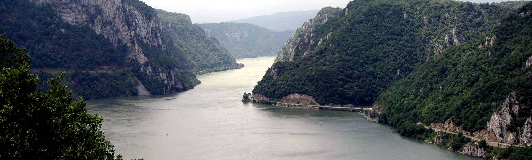
Photo: http://travel.webshots.com/photo/1015961012029815114XVtKetslHN
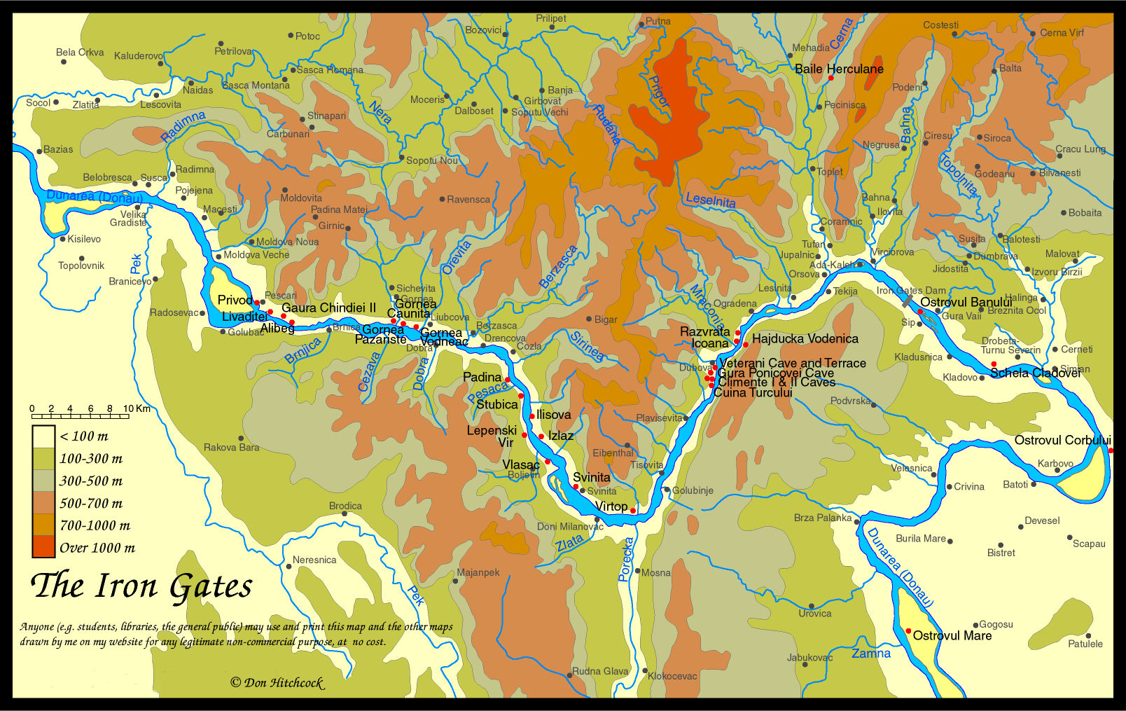
Map of the Iron Gates region, with the position of Lepenski Vir marked.
Photo: Don Hitchcock 2014
Much of this text is adapted from "Lepenski Vir" by Dragoslav Srejović 1972
Dragoslav Srejović was a giant. This book is a masterpiece, and deserves a wider audience.
Gospodin Vir is the name given to the whole north-south section of the Iron Gates Gorges in which Lepenski Vir is situated.
Lepenski Vir is a Mesolithic site - that means middle stone age, in this case 8 000 years before the present, after the ice had begun to melt from the glaciers which covered so much of the Northern Hemisphere. It is an open air site, not a rock shelter.
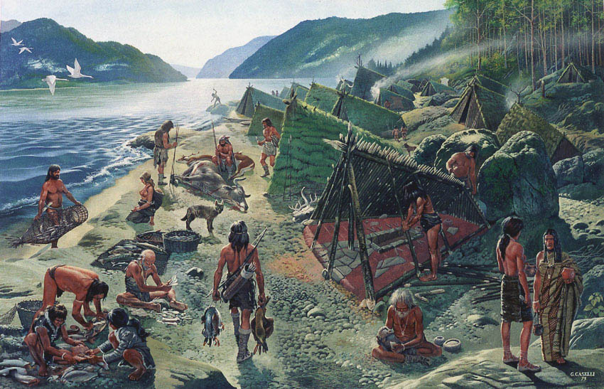
Lepenski Vir as it was 8 000 years ago, when it was a thriving community on a restricted area on the right bank of the Danube River, in the middle of the Djerdap, the Iron Gates Gorge.
This superb image is displayed here by kind permission of the artist Giovanni Caselli, a master craftsman and artist with a very broad knowledge of archaeology. Note the fish trap, baskets of fish, the trapezoidal house under construction, the stone hearth, the aurochs and deer, the water birds which have been caught, the spears and bow and arrow, the dog/wolf, the making of a sculpture, and the clothes.
Photo: http://www.muzej-mpek.org.yu/lepvir.htm

Professor Dragoslav Srejović (1931 - 1996) discovered and excavated the sites of Lepenski Vir and Vlasać.
Professor Dragoslav Srejović was born in 1931 at Kragujevac, Serbia. He studied at Belgrade University, taking his doctorate in archaeology in 1954. His doctoral thesis was written on the subject of Neolithic and Eneolithic Anthropomorphic Figurines in Yugoslavia, and was published in Belgrade in 1964. He became an Assistant Professor in 1958, Senior Lecturer in the University in 1966, and Professor of the Prehistory of the Balkan Peninsula in 1970. His excavations have included sites of the Neolithic, Bronze Age and Roman periods. Of special importance are his excavations from 1965 to 1971 in the area of the Iron Gates (Djerdap), where he discovered and excavated the sites of Lepenski Vir and Vlasać - two key settlements for the mesolithic and protoneolithic cultures in south-east Europe. He was a member of the Yugoslav Academy of Sciences and Arts, and published many articles in learned journals on Yugoslav archaeology, notably about the site of Lepenski Vir.
Photo: Dust jacket of "Lepenski Vir" by Dragoslav Srejović 1972
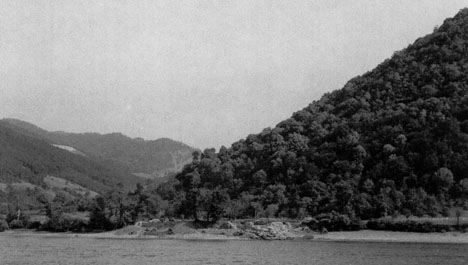
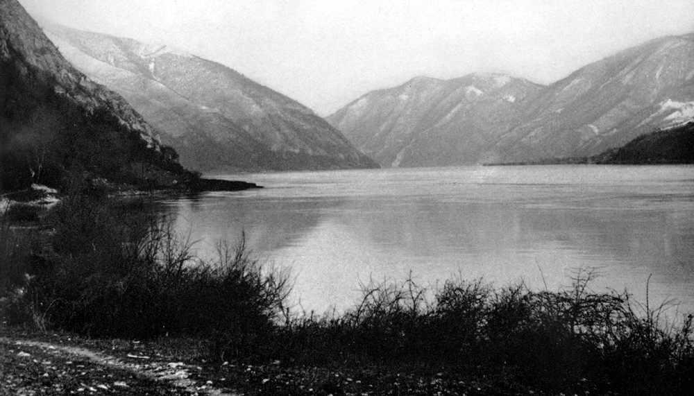
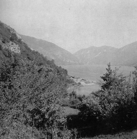
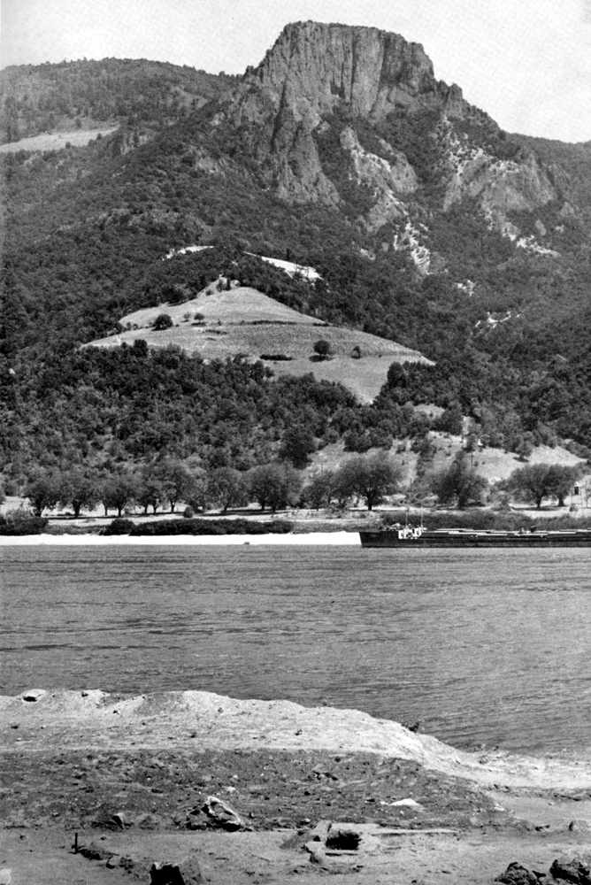
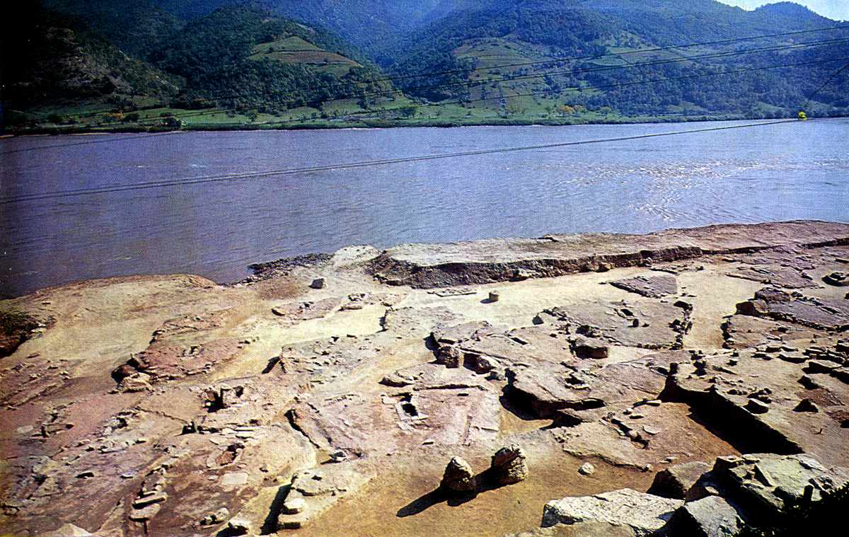
On the left, Lepenski Vir and its surroundings before the dam flooded the site. The prehistoric settlement was built on the sunny right bank of the Danube, between the steep slopes of the Koršo hills and the spring high water mark on the low porphyritic rocks which stretch down to the river, shown here in summer. The settlement of Lepenski Vir was on the low shelf in the middle of this photograph, projecting into the river.
On the right, Lepenski Vir as it is now.
Photo (left): "Lepenski Vir" by Dragoslav Srejović 1972
Photo: (right) http://outdoors.webshots.com/album/558132902opfLBE?start=12
Lepenski Vir is the name of the great whirlpool in the middle of Djerdap and the nearby horseshoe-shaped shelf between the right bank of the Danube and the steep cliffs of the Koršo hills. A group of experts from the Belgrade Archaeological Institute who visited this spot for the first time in late summer 1960 noticed on the bank, in shallow cross-section, an indeterminate layer containing fragments of pottery belonging to the Starčevo group, the oldest culture of the Late Stone Age (Neolithic) in the Danube Basin. It was concluded from the area available for habitation, and the simple culture layer which appeared to contain nothing of interest, that the Neolithic settlement at Lepenski Vir was not of any great extent, had existed for only a short while and was very poor.
The impression gained by the author when he visited Lepenski Vir in August 1965 was even less encouraging. The Danube floods had carried away almost the whole levelled area of the shelf, and the stratigraphy was still more indeterminate. It was noticed that the foundations of a Roman guard-tower had partially disturbed the layers to a considerable depth, and stone weapons and numerous sherds scattered thickly on the bank showed that the central part of the settlement had been completely destroyed. When excavation was begun, therefore, it was in the belief that the site represented the extreme periphery of a Neolithic settlement of minor importance which, furthermore, was at a considerable distance from the great centres of the Starčevo culture in the Pannonian Plain and the Morava Basin.
As important results were not expected, the scale of operations was modest; in August 1965 only two trial-trenches were opened, investigations being limited to an area of fifty-one square metres. The outcome was truly astonishing - beneath the layers visible in cross-section, which contained the remains of a settlement from early Neolithic times, a hitherto unknown culture of the greatest archaeological significance came to light. Its basic features, however, were only gradually revealed: in 1966 the greater part of the settlement was excavated, including imposing architectural remains; in 1967 several monumental stone sculptures were found, and in 1968 a part of the necropolis was examined. Though the excavation of Lepenski Vir had not been completed, the superficial area Of 2 500 square metres investigated showed that the culture revealed there was a completely new feature in European prehistory.
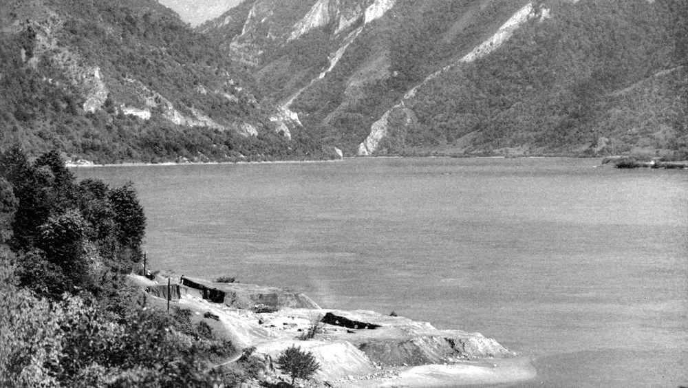
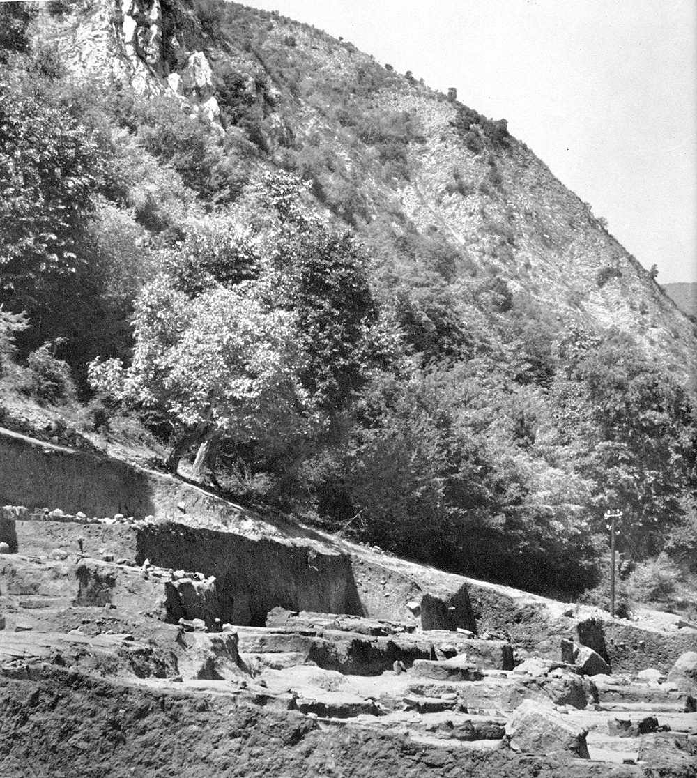
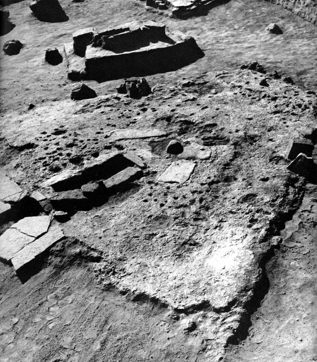
A closer shot showing the shelf of Lepenski Vir in the process of excavation. The site was ideally situated for fishing from the Danube, with shallow water close by, dropping to much deeper levels further out.
Photo: "Lepenski Vir" by Dragoslav Srejović 1972
The Lepenski Vir culture is recorded clearly and in detail. Its stratigraphy has been plotted, the basic elements of its structure are known and the course of its development is clear. None the less, it is today a phenomenon isolated in time and space. The forms of a highly developed culture, a permanent settlement with an architectural plan which presupposes complex socio-economic relationships, and examples of monumental art certainly imbued with a profound religious sense, have been found at Lepenski Vir, initially a featureless area affording no sort of expectation of discoveries, nor of any tradition of earlier settlement. On the other hand, all the essential forms of the Lepenski Vir culture differ completely from the general cultural-historical pattern of the early prehistory of Europe. It seems that nothing created in the Danube Basin before or at the time of the flowering of the Lepenski Vir culture (Early and Middle Stone Age) can explain its exceptional nature, nor are its highly expressive activities endorsed by the events that directly followed it (the beginnings of the oldest culture of the Late Stone Age, Starčevo-Körös-Cris types). The Lepenski Vir culture had its precursors but not its ancestors; its heirs are known but not its descendants.
The slopes of the Koršo hills above Lepenski Vir are overgrown with virgin forests of oak, walnut, hornbeam and hackberry.
Photo: "Lepenski Vir" by Dragoslav Srejović 1972
These facts make the scientific approach to the Lepenski Vir culture difficult and call for a prior investigation of the basic development of the cultures of the early prehistory of the Danube Basin and of Europe. This type of investigation, however, presents certain difficulties. Insufficient field work has so far been carried out in the districts of the Danube Basin, especially Djerdap and its immediate vicinity. If the cause is to be judged by the effect, then one must conclude from the evidence of Lepenski Vir that the cultural past of the Danube Basin is far richer and more complex than has hitherto been suspected. Lepenski Vir is exceptional and distinct not only because of still unrevealed evidence from the cultural history of the Danubian lands but also on account of the limitations inherent in the standard archaeological nomenclature, above all in the classic and generally accepted division of the early prehistory of Europe into Early (Palaeolithic), Middle (Mesolithic) and Late Stone Age (Neolithic).
In this scheme, which is basically an over-simplification of the idea of the straightforward development of culture, no provision has been made for subtle variations, exceptional development, lack of continuity or sudden transformations - in short, for all those countless departures from the norm that exist in real life, a number of which must have taken place just at Lepenski Vir. As will be seen later, the newly revealed culture of Lepenski Vir contains certain features which could equally be appraised as Palaeolithic (art, religion), Mesolithic (economy) or Neolithic (permanent settlement). Looked at collectively, however, they represent a new phase in the early prehistory of the Danube Basin, a distinct stage of culture which emerged over centuries and without which it would not be possible to accept the two most significant advances of the 'Neolithic Revolution' that lay ahead: agriculture and stockbreeding.
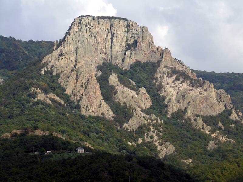
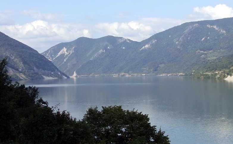
Treskavac - a bare porphyritic cliff (679 m high) which rises on the left bank of the Danube opposite Lepenski Vir like a giant sentinel of the prehistoric settlement.
Photo: (left) "Lepenski Vir" by Dragoslav Srejović 1972
Photo: (right) http://outdoors.webshots.com/album/558132902opfLBE?start=12
The stratigraphy of the Lepenski Vir culture shows that it was formed before the beginning of the Early Neolithic in the Danube Basin, i.e. before 5000 BC. However, its rich and original features are hard to reconcile with the more or less contempory elements of the Mesolithic culture of the Danube Basin and within the context of the earliest Neolithic cultures in the south of the Balkan Peninsula, 'in Macedonia (Nea Nikomedeia), Thessaly (the Pre-Ceramic Neolithic of Argos) or central Greece (Elateia). Compared with Lepenski Vir the Mesolithic forms of these areas seem amorphous and extremely poor, and the earliest Neolithic forms unoriginal and monotonous. This shows that the tenor of the Lepenski Vir culture differed from that of contemporary or subsequent cultures; its roots go farther back into the past and spread well beyond the boundaries of its native district.
It is difficult today to establish where and when it was that the ground was prepared for the emergence of the Lepenski Vir culture. Geographically, Lepenski Vir lies almost on the frontier between the middle and the lower Danube Basin, otherwise Djerdap, connecting the Pannonian Plain with the Wallachian and Pontic Basins. The region of the middle and lower Danube Basin is not, however, a closed geographical area. It is closely linked, by the many tributaries of the Danube, with all the other areas of central and south-eastern Europe, which means that Lepenski Vir could be an integral part of the prehistory of all that extensive area. It is reasonable to assume, therefore, that the origins of the Lepenski Vir culture lie in the areas which are directly or indirectly linked to the Danube.
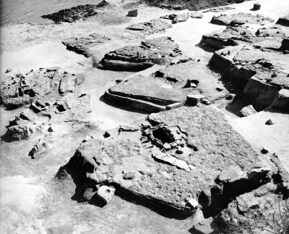
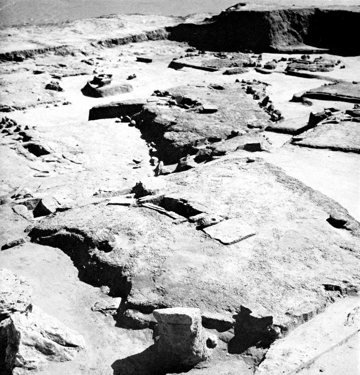
Lepenski Vir I - the south eastern part of the settlement. In the middle distance is the foundation of the large house No. 37 (Lepenski Vir Ic) which cuts into the north wing of building No. 38 (Lepenski Vir Ib).
Photo: "Lepenski Vir" by Dragoslav Srejović 1972
The earliest history of this area is only fragmentarily known. There are few remains of the Early Palaeolithic and only from the Middle Palaeolithic period onwards is it possible with any certainty to reconstruct the culture movements in the Danube Basin. Moreover, the culture of the Middle Palaeolithic, characterized by cave dwellings, flint weapons of moderate size and the complete absence of any creative artistic sense, does not tally with any of the features of the Lepenski Vir culture.
Djerdap is one of the most remarkable natural regions in Europe. This gorge, not quite a hundred kilometres long, is a world of its own, restricted but not monotonous, infinitely varied and dynamic. Within short distances, both in a vertical and a horizontal direction, soil, climate, fauna and flora quickly change; whereas the winds howl around the cliff tops covered with sparse oak or pine, at the foot of the cliffs, beside the water, grow holm-oak, finger-ferns, sycamores and hackberries. Often, not more than a kilometre away, also by the water, quite a fresh ecological zone exists, with differing soil, climate and way of life. Nowhere else in Europe does a territory, topographically enclosed and manifesting the same overall biotype, contain such numerous and local variations as in Djerdap. Nowhere, in a single area, are there so many surprisingly different landscapes and so many varied forms of forest, scent and colour.
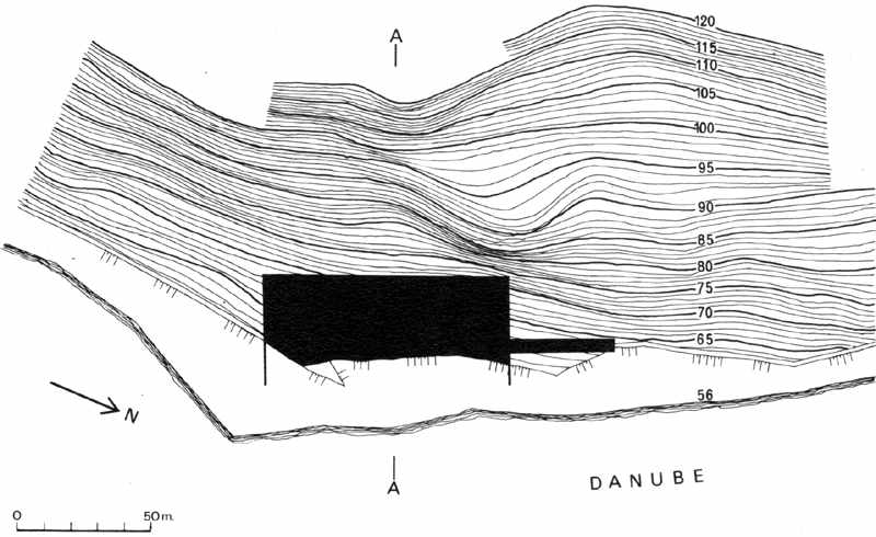
In this unusual world Lepenski Vir holds a special place. Djerdap, which cuts through the southern Carpathians between the Pannonian Plain and the Wallachian-Pontic Basin, has, on the whole, a west-east orientation, but its middle reach veers to a south-easterly direction, so that the Danube at this spot achieves great speed, creates its biggest whirlpools and carves gigantic sculptures from the rocks which rise from the river bed. In this part of Djerdap, on the sunny right bank of the Danube, lies Lepenski Vir, a small horseshoe-shaped shelf protected by dense forest and high cliffs. The site is in eastern Serbia, on the frontier between Serbia and Romania at a height of from 59 to 66 metres above sea-level.
From Lepenski Vir one can see the course of the Danube for almost six kilometres with its rocky banks rising precipitously to between 250 and 700 metres. Two kilometres to the north and six kilometres to the south, high cliffs constrict the river, shut out the view and form a huge isolated amphitheatre around Lepenski Vir. Out of the river bed upstream rise two enormous porphyry rocks, whereas downstream the Danube thunders noisily over a long underwater ridge and is then quickly lost to sight beyond the cliffs of the Bo1jeti hills. Here the river becomes a terrifying force in constant movement. Above, on the heights, the undulating summits of the southern Carpathians close the circle around the river and when the clouds or mists hang low over their peaks the whole area is shut in and becomes even more restricted, with no apparent way out. This isolation makes climate, vegetation and the whole rhythm of life at Lepenski Vir different from those in other parts of the gorge.
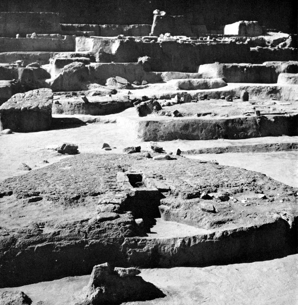
Lepenski Vir I - the north eastern part of the settlement looking towards the Danube. In the foreground the foundation of house No. 24 (Lepenski Vir Ie).
In the middle distance houses Nos 19 (Lepenski Vir Id), 31 (Lepenski Vir Ic) and 23 (Lepenski Vir Ie) and in the background, near the Danube bank, houses Nos 10 (Lepenski Vir Ic), 11 (Lepenski Vir Id), 9 (Lepenski Vir Id) and 7 (Lepenski Vir Ic).
Photo: "Lepenski Vir" by Dragoslav Srejović 1972
The Djerdap region is exposed to the influence of the steppe climate from the east and the continental climate from the west but it is sheltered by the high ranges of the Carpathians both from the northern cold air currents and the excessive summer heats from the south. At Lepenski Vir the normal east or west winds are cut off by the sudden southward bend of the Danube. Consequently this area has its own distinct micro-climate, marked by uniform rainfall, mild transitions between seasons, a considerable relative humidity, and the absence of strong winds or of extreme temperature variations (see Appendix 1). Its wholly sheltered situation, the limestone subsoil which retains warmth, and the river with its mists which hang over the waters and move slowly along the eddies have made possible the survival in this part of Djerdap of many rare and very archaic forms of life.
At Lepenski Vir, situated in the middle of a forest belt about three kilometres long, many types of vegetation still survive which have died out even in the immediate vicinity because of the extreme climatic variations in the course of the Ice Age and the Post-Glacial period. The Mediterranean varieties which flourish there today, especially the hackberries, grew around Lepenski Vir in the Pre-Boreal period, together with birch, juniper, pine, spruce, tsuga and beech. The remnants of surviving forest show that there has been a continuity from the Tertiary to the present day, that is to say the climatic changes of the Quaternary, which caused such havoc in much of the world in other parts of the Danube Basin, only partially restricted or extended the already existing life cycles in the area of Lepenski Vir.
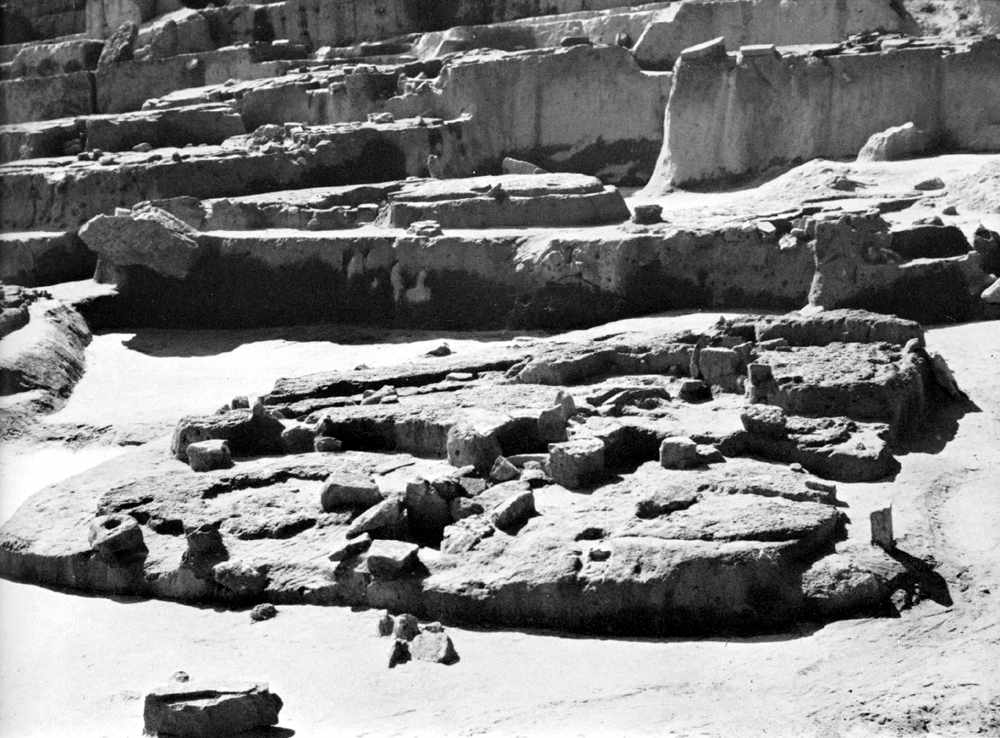
Lepenski Vir I - the south eastern part of the settlement (seen from the Danube bank). In the foreground is the foundation of house No. 4 (Lepenski Vir Id).
Photo: "Lepenski Vir" by Dragoslav Srejović 1972
When man appeared on the scene, the landscape did not differ essentially from that of the present day. The presence of considerable quantities of birch pollen and the sporadic appearance of tsuga pollen in the lowest levels at Lepenski Vir bear witness to the harsher climate, certainly very cold on the summits of the surrounding hills, but warm enough near the water, as is proved by the hackberry and beech pollen found. The river, the bank, and all the features of the area were, however, the same.
The first settlers at Lepenski Vir found not only a raised terrace sheltered from the harsher winds and the flood waters of the Danube, but also an abundance of life in the forest and the waters. The spot chosen for building the settlement was clearly the most suitable in the area; on the southern and northern sides it was bordered by low crests of dark red porphyry, on the west by the steep slopes of the Kor:so hills, while to the east, on the left bank of the Danube, rose the bare summit of Treskavac, 679 metres high, like a gigantic sentinel of the settlement. North of Lepenski Vir the bank is high, at times almost vertical, and to the south low and easily accessible as far as the mouth of the river Boljetinka and its gorge which provides a short route to the mountainous hinterland.
Lepenski Vir I - the north eastern part of the settlement (seen from the Danube bank). In the foreground can be seen houses No. 29 (Lepensk Vir Ib), 22 (Lepenski Vir Id) and 21 Lepenski Vir Ie) which are built one above the other. In the background rise the stepped terraces formed at the time of construction of the houses on the steep western slopes of the horseshoe shaped shelf.
Photo: "Lepenski Vir" by Dragoslav Srejović 1972
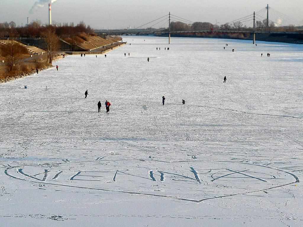
Photo:
http://community.webshots.com/photo/547610576/2137689540046091027mlMIKg#
(Note that the restrictions below apply only in summer. In winter when the Danube froze over, it became an easily accessible highway to areas far upstream and downstream. See this photo of the Danube at Vienna in 1996. The Danube is frozen solid enough to bear the weight of people, with a thin layer of snow over the ice. - Don)
There are not many paths from Lepenski Vir. Except for the narrow valley of the Boljetinka, seventeen kilometres long, there is not a single route in the whole district leading into the interior of the country. It is possible to make one's way along the Danube bank, but generally only when the water level is low. Even then it is a long and laborious Journey to reach the mouth of the river Poreć on the right bank of the Danube or the mouths of the rivers Berzaska and Cerna on the left, whose valleys lead, respectively, southward into the Homolje mountains or northward to the Transylvanian Alps. (note, however, that these restrictions do not apply to boats. There is no evidence that they had them, of course, but absence of evidence is not evidence of absence. - Don)
The first settlers, however, had no need to go far from Lepenski Vir either for economic or psychological reasons.
Though Lepenski Vir and its immediate surroundings are distinguished by a stony, infertile bank and complete isolation from the rocky mountain hinterland, two practically inexhaustible food sources were to be found at the site: the forest, full of game and with an abundance of fruit-bearing trees, and the river, rich in fish. On the other hand, the Danube at this point penetrates the core of the southern Carpathians and makes easily accessible the varied rocks and minerals which exist in them. Above Lepenski Vir itself sediments formed during the Jurassic and Calcareous period are exposed: grey-green sandstone, reddish limestone and bluish-grey marl. A little farther on, the waters have laid bare Palaeozoic schists, granite, serpentine and gabbro, as well as Permian formations of porphyrite and red sandstone. Furthermore, when the water level is low, the Danube leaves behind on the bank a brilliant polychromatic mosaic of ores and minerals brought down by the swift-flowing tributaries from the mountainous hinterland. There are also shells, snails and fossils washed out from the shattered rocks, and along the bank itself stretches dense forest, with oaks, hackberries and long sinewy creepers and countless other growths which could serve as firewood and excellent building material.
Foundation stones of house No. 3 (Lepenski Vir Ib). The entrance is paved with wide stone slabs and on the sides of the foundation can be seen the reinforced stone sockets for the roof construction supports. The household sanctuary is bounded by three stone slabs with a single aniconic boulder in their centre.
Photo: "Lepenski Vir" by Dragoslav Srejović 1972
Access to this treasure-house was not, however, simple and easy: the forest around Lepenski Vir even to-day has all the features of virgin forest. Directly by the bank, for a distance of about five hundred metres, there are dangerous whirlpools. Scree slides uninterruptedly from the summits of the Korso hills and from time to time there are falls of large and heavy rock.
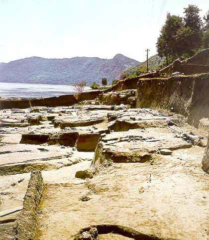
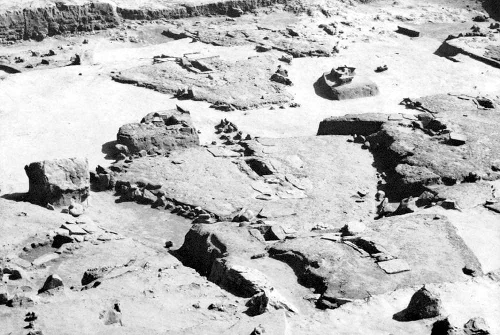
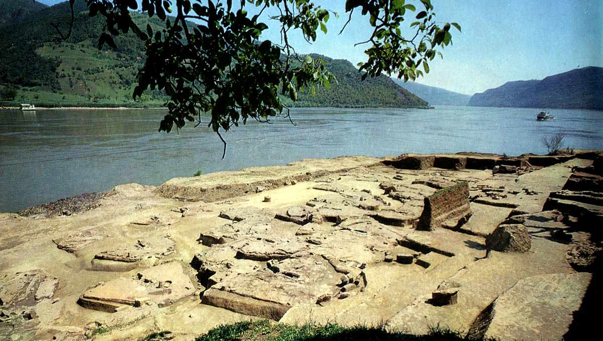
Photo of the excavation area at Lepenski Vir, on the right bank of the Danube River, in present day Serbia.
Photo: http://www.cimec.ro/livingpast/nr1/boroneant/schela_cladovei/arta/fig20.htm
Click on the image for a larger view.
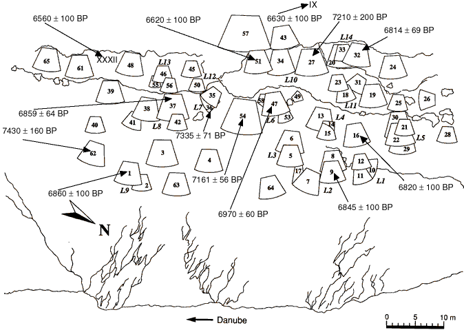
General plan of the Lepenski Vir I habitations, showing house locations "L", as well as radiocarbon dates of some houses based on charcoal samples. After Radovanović, 1996, with acknowledgement to Boric 1999 and Bailey 2000. The radiocarbon ages of houses 36, 37 and 54 are weighted means of several measurements. The locations and ages of two Lepenski Vir II houses, IX and XXXII, are also shown. From: Bonsall et al, 2000, 'Stable Isotopes, Radiocarbon and the Mesolithic-Neolithic Transition in the Iron Gates', Documenta Praehistorica XXVII.
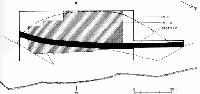
Proto-Lepenski Vir
(adapted from "Lepenski Vir" by Dragoslav Srejović 1972)
Lepenski Vir I. View of the settlement from the slopes of the Koršo hills.
Photo: "Lepenski Vir" by Dragoslav Srejović 1972
The history of Lepenski Vir begins at the water's edge, on the very bank of the Danube. The first settlers of Proto-Lepenski Vir inhabited only the lowest terrace by the bank. Only on this terrace, formed in the course of the Late Glacial period, Dryas 2-3, in sandy yellow sterile loess with an average depth of 0.5 m above red porphyrite have the modest remains of the first settlement been found.
At first the south eastern part of the terrace in the immediate vicinity of the great whirlpool was settled, and the settlement then gradually extended up stream to the north west as far as the cliff which limited the shelf at its northern end. The settlement was never very large, but it covers a large time span.
(Note, however, that although Srejović posits that this is the first settlement at this site, there is no dating evidence for the age of Proto-Lepenski Vir - Don)
Topographical map of Lepenski Vir showing the area investigated.
Photo: "Lepenski Vir" by Dragoslav Srejović 1972
The edge of the settlement along the river bank was slightly concave, and nearly level along its width. The settlement was only about 12 metres wide in the central portion, gradually decreasing in width at either end. The buildings were distributed about 5 to 12 m. from each other. The river must have been an ever present danger as well as a source of water and food, for the Danube floods regularly.
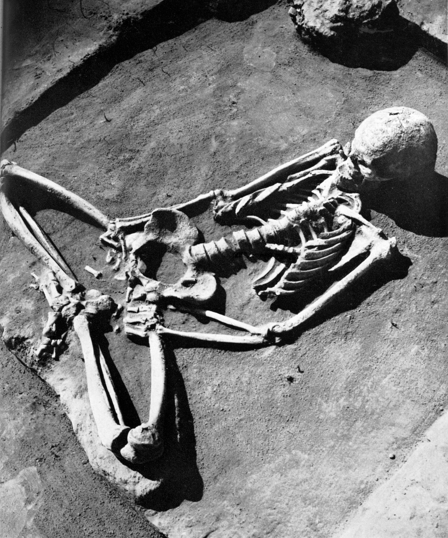
A grave discovered in the south-eastern part of the settlement of Proto-Lepenski Vir. The shape of this grave, as well as the position of the skeleton, is quite exceptional. The shallow grave pit has approximately the same trapezoidal form as the foundations of the houses of Lepenski Vir I and has the same orientation as the buildings of that settlement.
Photo: "Lepenski Vir" by Dragoslav Srejović 1972
Eight dwellings were found, two in the central section of the elongated ellipse that marks the settlement, and three each at the northern and southern sections. All the dwellings were about fifteen metres from the present river bank. The terrain between the dwellings and the river is almost flat and an ideal open air living area.
Behind this first settlement the stony substrate begins to surface through sandy alluvial and wind borne deposits, sometimes forming small recesses and thus shelters which were incorporated into the architecture of the first settlement.
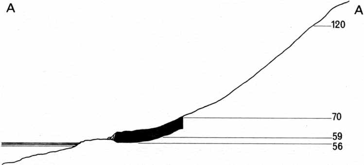
Cross section of Lepenski Vir showing the area investigated.
Photo: "Lepenski Vir" by Dragoslav Srejović 1972
Only the nuclei of the first settlement remain. The hearths are discernible, with household implements of stone and bone. The living spaces cannot be delineated from their surroundings. There are no traces of walls or roofs, and it is assumed that the house foundations are not preserved because of the loose sandy ground, unfavourable for the preservation of wood and post holes. In any case, any post holes which may have been made were not reinforced with stone, another indication that the roofs were lightweight, without the need for secure foundations.
The hearths are the only clear architectural elements of the first settlement, but they are painstakingly constructed on a standard design. All the hearths are built of vertically placed limestone slabs (easily obtained from the slopes nearby) usually with dimensions of 30 x 25 x 10 cm, as well as smaller fragments. Since the grey limestone slabs are placed vertically the depth of the hearths is around 30 cm. The hearths were around 0.8 m to 1.0 m long, by about 0.20 m to 0.25 m wide.
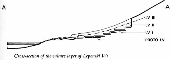
Cross section of the culture layer of Lepenski Vir.
Photo: "Lepenski Vir" by Dragoslav Srejović 1972
The first settled south eastern section had rectangular hearths constructed on the ratio of 4:1 with regard to length to width. By the time the north western area was settled, the ratio had changed to 3:1. In all cases the hearths are about the same distance from the river bank, with their long axes pointing to the river. This implies a similar orientation of the dwellings.
However the lack of any indication of foundations implies that the roofs of the dwellings were exceptionally lightweight, possibly woven or plaited reeds or skins, which have since completely disappeared. Despite this lack of clarity as to the layout of the houses, it is characteristic that the household goods and animal bones are concentrated on the western, narrower side of the hearths, away from the river, and were never found on the eastern side. This shows that the hearths were not placed in the centre of the living space, but were near the eastern side of the dwelling.
Cross section of the inhabited area of Lepenski Vir.
Photo: "Lepenski Vir" by Dragoslav Srejović 1972
Thus, one of the foundation boundaries passed close the narrow eastern side of the hearth. The boundary of the western side would be close to the boundary of the household detritus. In some cases the pile of animal bones extended as much as 2.5 to 3 m. westward from the hearth, usually right up to the rocks sticking up out of the subsoil forming the next level of the site. Since the hearth was about one metre long, the total depth of the building must have been at least 3.5 to 4 metres.
The recesses formed by the stones at the back, and in one case also a part of a bow shaped stone surround which has been preserved, suggest that the contours of the foundation were rounded, forming a circle, an ellipse or some allied shape. On the basis of the architecture of the next phase, Lepenski Vir Ia, one may suppose with some degree of certainty that the foundations of the first dwellings at Lepenski Vir were egg shaped, the narrower end turning towards the slopes of the shelf and the wider end facing the river. Such a shape fits ideally into the relief of the terrain, into the pockets and recesses formed by the rocks in the subsoil and on the slopes of the shelf above. Thus when seen as a whole in combination with the foundations, the shape of the roofs may well have been that of a funnel, with a circular cross section.
The hearth is once again integral to the final design, since the 4:1 ratio of the hearth is reflected in the length of the dwelling in relation to the hearth, also 4:1 at least in the earlier settlement in the south-east. However in the later dwellings of Proto-Lepenski Vir situated in the north-west, the slabs are no longer placed vertically, but are placed horizontally. This has the effect of defining the hearth more clearly. In addition the ratio was changed to 3:1 for the ratio of length to width. This method is the one used in Lepenski Vir I which indicates that these hearths of Proto-Lepenski Vir are indeed later versions, since they comply so closely with the style of Lepenski Vir I.
Lepenski Vir I
(adapted from "Lepenski Vir" by Dragoslav Srejović 1972)
Lepenski Vir I. View of the settlement from the north-west, looking over the Danube which flows left to right in this photograph.
Photo: "Lepenski Vir" by Dragoslav Srejović 1972
Lepenski Vir I consists of a dense mass of eighty five buildings covering a limited area of two thousand square metres. The buildings are crowded together, often cutting into or covering one another. Building activity over this long period of time was intensive; houses were continually being put up, renewed, extended or rebuilt. The frequent renewal of the floors, which were of very firm construction, shows that every house was inhabited for a very long time (this reminds me forcibly of the domestic upheaval when 21st century houses are refurbished! - Don).
The mutual intersection of foundations horizontally and vertically presupposes a considerable number of separate building stages and the fact that in some places as many as four or five houses lie one on top of the other and that the floors are divided by layers 25 to 50 cm thick enables us to confirm the basic phases of the history of Lepenski Vir I.
House No. 54 (Lepenski Vir Ib), more distant shot taken from the other direction showing the organisation of this central large house and its relative size and thus importance.
Photo: "Lepenski Vir" by Dragoslav Srejović 1972
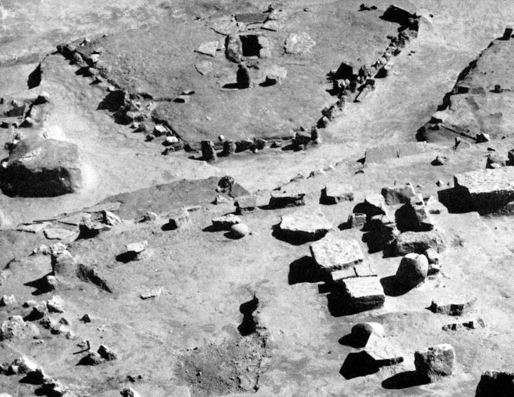
The complete foundations of the central large house No. 54 (Lepenski Vir Ib and Ic) may be seen here behind the central large house of Lepenski Vir II (No. XLIV). It is not an accident that the two are placed in a similar location, in a commanding position over the rest of the settlement.
Photo: "Lepenski Vir" by Dragoslav Srejović 1972
Since building activity never ceased, the settlement as a whole was in a continual state of change, expanding and contracting rhythmically. Whereas in one part new houses were being built, in another old ones were only being renewed or adapted, and then the whole process would be repeated in reverse. (This means that the history of Lepensk Vir I was a record of specific phases in a continual reinvention of the settlement, one of the first examples in human history of the city state, or at least a village state. - Don)
Five separate settlement plans, Lepenski Vir Ia - Ie can be distinguished. These plans do not signify either a complete new settlement or the reconstruction of any of its individual parts, but only fix a specified number of characteristic situations in the long and uninterrupted history of Lepenski Vir I.
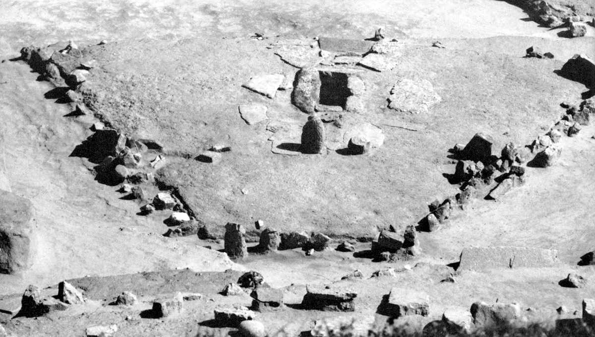
Lepenski Vir I - the south eastern part of the settlement. In the foreground is house No. 45, in which the sanctuary is marked only by a stone 'table' and an altar (see close up below) embedded in the reddish limestone mass of the floor.
Photo: "Lepenski Vir" by Dragoslav Srejović 1972
The basic building plan for the architecture of the new settlement was defined during the first building phase, Lepenski Vir Ia. Methods of house building, the design and arrangement of the houses, as also the main communication paths, were similar in all five levels. Not a single change was made subsequently in the basic structure of the nucleus of the settlement. This was not a sign of creative stultification but the acceptance of the values expressed at the tme of the initial cultural upsurge and subsequently confirmed by tradition.
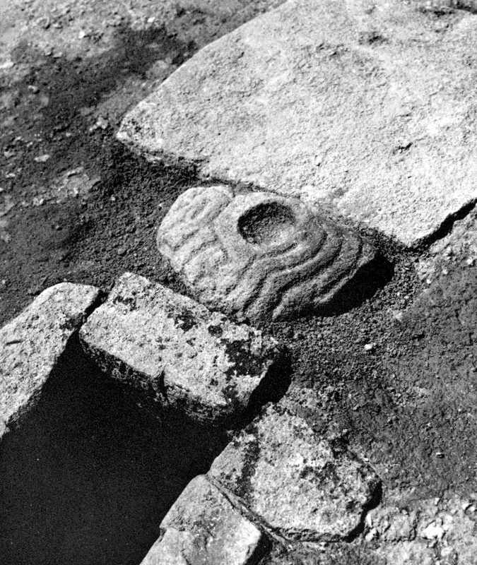
The hearth in house No. 45; between it and the stone 'table' is an altar carved in the semblance of a fish.
Photo: "Lepenski Vir" by Dragoslav Srejović 1972
Lepenski Vir Ia was the work of an exceptionally gifted generation. At a most surprising speed, and without discernible preparation or experimentation the final form of the houses was determined, definite limits were laid down for the settlement, and new methods, proportions and building materials were found.
(Note that the architecture of Lepinski Vir Ia (and later) is repeated at Padina B, Vlasac and at Stubica. It seems to me that this must have been under the guidance of a very forceful and gifted leader (or leaders). Only such a leader could have seen the potential of the sites which had limited space which needed to be used in the most efficient way possible, and a way of adapting to them which could have allowed the villagers to make the most of the sites and the resources available. That this method and tradition continued for so long and in more than one place is a tribute to this organisational and building design genius(es). It is also apparent that the people of the sites had the same or similar religions and world views, and that there was communication between the peoples of the sites. It would seem that Lepenski Vir Ia was the first of the sites thus to be utilised in this way, but Padina and Vlasac followed the tradition soon after. Not much is known about Stubica, except that the architecture was similar. The rising waters of the dam precluded major field studies at Stubica so far as I can ascertain. - Don.)
Lepenski Vir Ia
(adapted from "Lepenski Vir" by Dragoslav Srejović 1972)
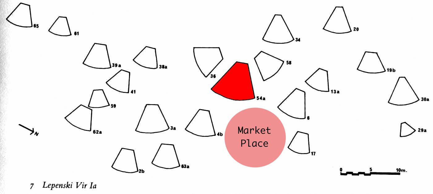
Lepenski Vir Ia showing the disposition of the houses and their plans and aspects.
The important house No. 54 is shown in red, and the market place in front of it has been added to the original drawing.
Photo: "Lepenski Vir" by Dragoslav Srejović 1972
Lepenski Vir Ia began with the discovery of new building materials and of a new building technique. It closed with the occupation of the central area of the shelf whose outlines also became the firm boundaries of the settlement. Of the eighty five houses excavated at Lepenski Vir I, twenty two certainly belong to Lepenski Vir Ia. Since they occupy almost the entire area of the shelf, it is certain that in the first building phase not more than thirty houses could have been built.
All the houses of the Lepenski Vir Ia phase are built of similar materials and in the same manner. They have an identical internal construction and similar proportions. They differ only in size.
In their construction wood and various types of stone in warm red, yellow and grey tones (limestone and sandstone) were employed; these are the colours of the bare cliffs in the immediate vicinity of Lepenski Vir. Whether the houses are on level ground or on the steep slopes of the shelf, one notices that the same system of measuring the terrain, establishing the foundations and building the superstructure has always been used.
The foundations of all the houses have the same trapezoidal form or, more accurately, form the sector of a circle with a subtended angle close to 60°. This shape is clearly defined and completely closed but is not geometrically rigid. It appears to have been variable, and houses were widened or narrowed within the design of a great circle, like a fan. It is difficult, however, to establish accurately the manner by which this strange, dynamic fan became the permanent feature of the inhabited area of the Lepenski Vir culture. A casual glance at the ground-plan of the houses is enough to convince one that their shape has no model in nature. Indeed, it may be concluded, by a careful comparison of all the foundations and measurements, that the builders of Lepenski Vir possessed a quite definite mathematical knowledge which they employed skilfully in measuring the terrain and fixing the proportions, shapes and dimensions of the houses.
The foundations were laid out on a system of triangulation. It always began with the fixing of the opening in the front of the house and the dimension thus obtained was applied to the sides which meet at the rear of the house. In this way a regular isosceles triangle was obtained. The final shaping of the foundation and all further construction, followed this triangle.
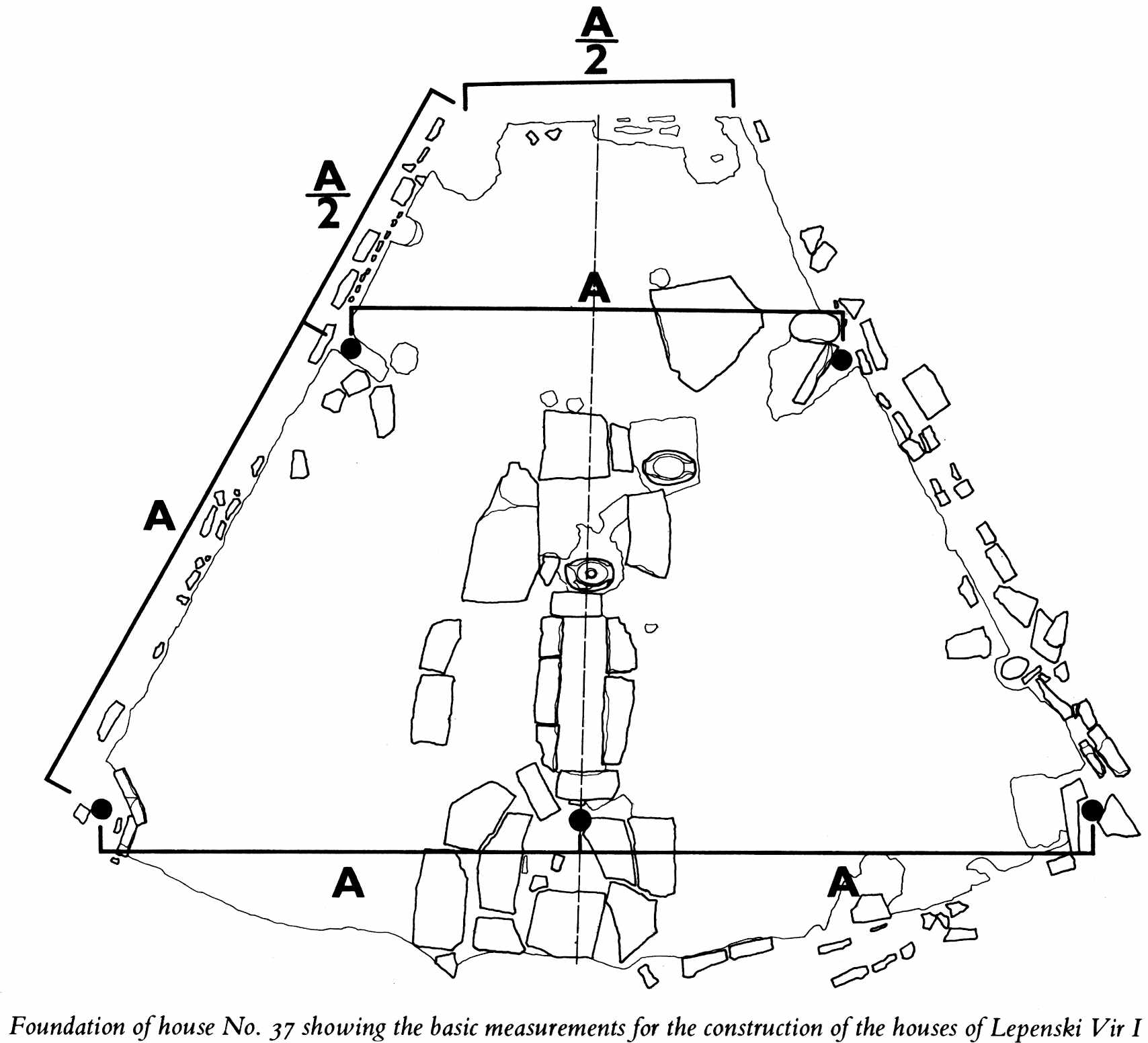
Foundations of house No. 37 showing the basic measurements for the construction of the houses of Lepenski Vir I.
Photo: Figure 8, "Lepenski Vir" by Dragoslav Srejović 1972
As can be seen on the diagram at left, the original isosceles (in this case equilateral) triangle was truncated at a point three quarters of the length of the two equal sides of the triangle, this truncation forming the rear of the dwelling. Three post holes were placed equidistantly at the front of the dwelling. Two further post holes were placed half way down the equal sides of the original isosceles triangle, or two thirds of the way along the now shortened sides, as shown. This gives final dimensions of four-three-one for the front, sides and back of the house.
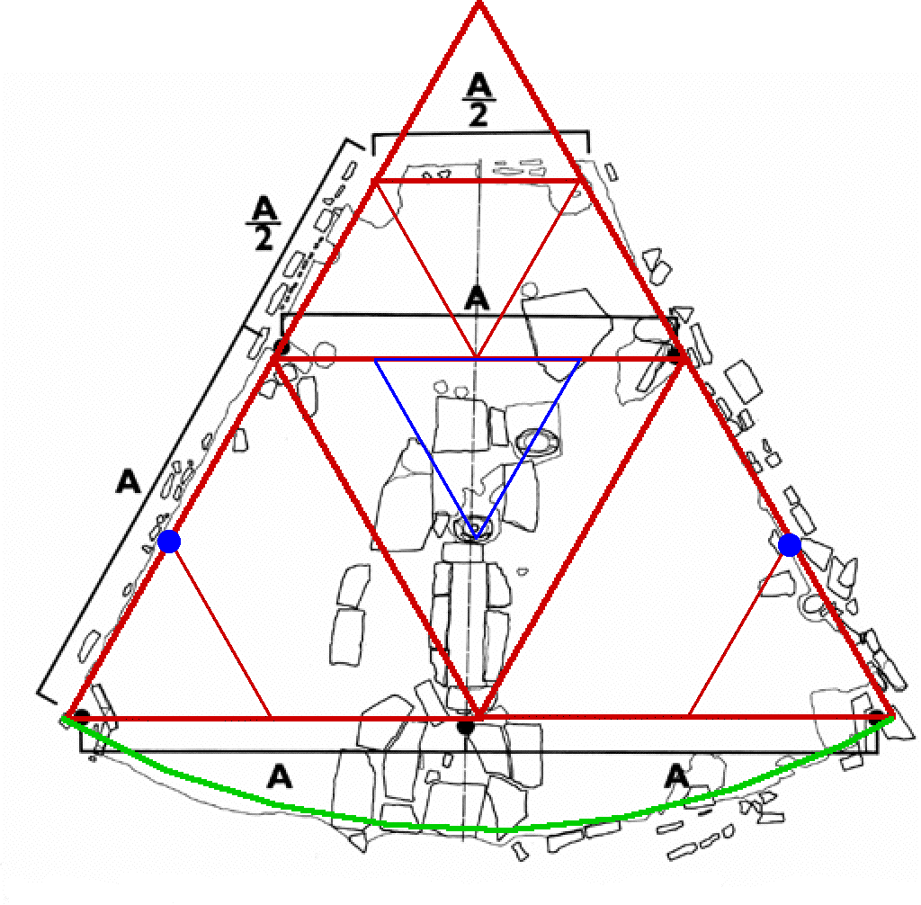
For comparison purposes I have superimposed a red equilateral triangle on the diagram for the foundations of house No 37, which has been further divided to show the relationships.
In addition, the front of the house was traced out as an arc, with the centre of the arc the original apex of the equilateral triangle, shown on the diagram in green. If this extra area, an apron at the front of the house, was under a roof, as seems likely, it is probable there was a roof tree to support the roof structure cantilevered forward of the three front posts.
The original foundations diagram for house No. 37 shows the disposition of the main poles as black circles. I have added the positions of the extra pair of poles (using blue circles) used for the "large" houses, again placed by the builders of Lepenski Vir at the standard distance of A/2. It is interesting that the builders did not see the need for putting substantial poles with rock strengthened holes in the ground at the very rear of the dwelling, no matter what size house was constructed.
The load supporting rear poles would certainly have been unnecessary if, as I have speculated elsewhere, the ridge pole was extended to the apex of the triangle and securely bedded in rock.
- Don
The edge of the foundation was bordered by a trench about 15 cm. wide and 10 cm. deep, filled with fine chippings at the rear and coarsely broken stones along the laterals. This provided a sleeper-trench for the shaped beams which acted as stays.
Post holes in the larger houses were lined with stone blocks and slabs placed vertically. The smaller houses did not have these stone linings while the larger ones had two additional post holes (one extra on each side) on the sides. But, whatever the number of supports, it is significant that the placing of the post holes at the edge of the foundation still adheres to the design of the original isosceles triangle. All three post holes on the house frontage are arranged along the base line of the triangle (in the middle of the base and in the apices of angles near the baseline). Where there are extra post holes along the sides, as is the case in the larger structures, these post holes are placed at distances corresponding to one quarter of the distance across the front, and one quarter of the sides of the original (close to equilateral) triangle.
The placing of the constructional supports determined the shape of the internal living area of the houses. The nucleus of the internal arrangement was the hearth built of stone blocks which formed a rectangular trench. Unlike the hearths of the Proto-Lepenski Vir phase, those in the Lepenski Vir la houses are always built of large and heavy slabs whose dimensions are usually 100 x 50 x 40 cm. or 60 x 40 x 35 cm. Furthermore, two new elements closely associated with the hearth appear regularly in the foundations of the houses, namely stone thresholds which link the shorter side of the hearth facing the frontage with the centre of the arched edge of the foundation, and a great egg-shaped or spherical boulder with circular recesses in the middle.
Note that the egg shaped boulder with circular recesses is not placed randomly. It is placed on the symmetrical axis of the house, and is carefully positioned so that it is one unit of length (in line with a position A/2 along the sides of the equilateral triangles on the diagram) from the front middle post of the house. It is at the apex of the blue triangle in the diagram above. The depth of the house as measured from the front central post is 2.6 times the basic A/2 unit, not 3 times, because of the trigonometry of equilateral triangles. The depth of the front stone apron brings the total length of the (actual) house up to a little more than the 3 times dimension, (3.13 for the purists!) since it would have been measured and marked out using a cord fixed at the original apex of the triangle, with the cord at a length corresponding to the width of the house at the front between the two outside posts. - Don
The width of the hearth is always one third of its length.
The stone thresholds which occupy the area between the arced front of the foundations and the hearth may well have been constructed in order to provide a solid entry area impervious to occasional rain and snow. - Don
Whereas the surveyeying of the terrain, the establishment of the contours of the foundation and the disposition of the objects in the interior of the house represent a real architectural achievement, the structure of the floor which overlies the foundation and consolidates all the constructional elements at once shows a significant technological discovery already made at the beginning of Phase Ia.
The floors of the houses in the Lepenski Vir I settlement are of exceptional construction. Their basic mass is composed of the sandy, marly red limestone which is found above Lepenski Vir itself on the jagged slopes of the Koršo hills. Laboratory analysis of the floors shows that they possess the so-called residual magnetism which is a consequence of baking.
This in practice means that the preparation of the flooring for the houses followed a regular technological procedure; the local red limestone was baked, and then by adding water, sand and gravel a viscous mass was obtained with the qualities of lime mortar.
This mass was poured over the foundation of the house and all the constructional details - the stone blocks which form the hearth, the thresholds, the rounded boulder in the centre and the stone slabs which line the post holes for the supports of the upper construction - were all embedded in it.
It was then smoothed before it hardened, and in some houses the floor was subsequently decorated with a thin red or white polished composition. Only after a certain time, when all moisture had dried out, did the floor attain the necessary firmness which meant it could be trodden on and used for daily living. Today it seems petrified, like natural breccia.
This appears to be one of the world's first uses of lime mortar, in this case as a floor covering, not as mortar between bricks or stones.
What is today considered to be the oldest concrete dates back in 7000 BC and is located in south Galilee, Yiftah El, in Israel . It was discovered in 1985 when a bulldozer was opening a street and forms a kind of floor. It is made of a mixture of lime with stones. Burnt lime (quicklime) when combined with water and sand forms a mortar which coming into contact with the carbon dioxide of the atmosphere becomes more stiff and renders a solid compound. If this mortar is mixed with stones, it bonds together the stones and forms a type of concrete. (this reference to the Israeli concrete comes from http://www.hcia.gr/2.html)
The earliest other known use of lime mortar dates to about 4000 BC in Ancient Egypt. Thus, the Lepenski Vir Ia culture's use (~5600 BC) of lime mortar predates the Egyptian use by 1600 years.
The following is adapted from Wikipedia:
Lime mortar may be created by mixing sand, quicklime, and water.
The earliest known use of lime mortar apart from Lepenski Vir dates to about 4000 BC in Ancient Egypt.
Quicklime is made by the following simple process:
CaCO3 + heat → CaO + CO2.
1. Calcination: heat limestone or marble, both of which contain primarily calcium carbonate, CaCO3, to 900° C.
2. The excessive heat then causes carbon dioxide, CO2, to be released as a gas.
3. The result is quicklime, CaO (calcium oxide).
When this quicklime is then mixed with water it forms calcium hydroxide, Ca(OH)2, also called hydrated or slaked lime. As the mixture dries the slaked lime reacts with atmospheric carbon dioxide, CO2, to form back into solid calcium carbonate, CaCO3, releasing yet more (evaporating) water in the process.
Lime mortar dries very slowly. In some buildings, lime mortar made of quicklime and sand alone may take several years or even decades to completely solidify as this process relies solely on the re-absorption of atmospheric carbon dioxide back in the mortar to form calcium carbonate.
It would seem, then, that the material used for the floor of the Lepenski Vir dwellings must have either had something added to it to hasten hardening, or perhaps the original marly limestone (marl means a stone which contains limestone and clay) contained enough minerals to act in a similar way to Pozzolana.
It should be noted that a modern replacement for Pozzzolana is rice husk ash from rice padi fields - so it may be that something similar could have been used by the Lepenski Vir inhabitants. Certainly they had plenty of wood ash. Whether this would work in the same way as rice husk ash is unknown. It would seeem that the additive needs to have high acidity to react with the alkaline slaked lime, but wood ash in my experience is usually alkaline, not acidic.
Pozzolana is a fine, sandy volcanic ash, originally discovered and dug in Italy at Pozzuoli in the region around Vesuvius, but later at a number of other sites. Vitruvius speaks of four types of pozzolana. It is found in all the volcanic areas of Italy in various colours: black, white, grey and red.
Finely ground and mixed with lime it acts like Portland cement and makes a strong mortar that will also set under water. It transformed the possibilities for making concrete structures, although it took the Romans some time to discover its full potential. Typically it was mixed two-to-one with lime just prior to mixing with water. The Roman port at Cosa was built of Pozzolana that was poured underwater, apparently using a long tube to carefully lay it up without allowing sea water to mix with it. The three piers are still visible today, with the underwater portions in generally excellent condition after 2100 years.
Pozzolan is a siliceous and aluminous material which reacts with calcium hydroxide in the presence of water to form compounds possessing cementitious properties at room temperature. This allowed it to be used in the Roman Empire to make cement by combining with lime and water. Pozzolanic ash occurs naturally in volcanic deposits from Pozzuoli and Naples.
The animal and fish bones found at Lepenski Vir indicate that the settlement may not have been used in the months of May, June and July (Source: the Iron Gates Mesolithic, 1996, by Ivana Radovanović)
If so, this would have been an ideal time to lay foundations, in late April, and allow three warm (though relatively wet) months for the foundations to harden as they absorbed CO2 from the atmosphere, before the residents returned in August. High temperatures shorten chemical reaction times. - Don
The floor is not of an overall even thickness. At the edges it is only one or two centimetres thick, whereas by the hearth, at the stone blocks and slabs, it is as much as 25 cm deep. This means that every construction, every stone block or slab, in fact everything which lies on the foundation, must first have been set in place and only then was the floor poured as a whole.
It is uncertain whether the floor was poured when the house had already been roofed or whether the upper construction was begun only after the foundations were finally completed. There is no strong link between the floor and the superstructure and therefore both processes might have taken place at the same time.
All that remains of the roof structure is carbonized beams whose traces are clearly visible on the (fortuitously hardened with lime mortar!) floors of the houses. Since the post holes for the supporting beams on the outer edge of the foundation are set obliquely, it is certain that the houses had slanting walls, the roof beginning at ground level.
The row of broken stones which edge the foundation in order to prevent the roof timbers slipping, and the stays placed along the sides show that the roof must have been formed in two planes whose ridge-pole must have sloped downwards towards the back in order to let smoke from the hearth escape, . Though it is uncertain how high the house frontage was it seems likely that the ridge-pole had an inclination of from 23° to 25° and that the roof fell (on either side) at an angle of between 55° and 60°.
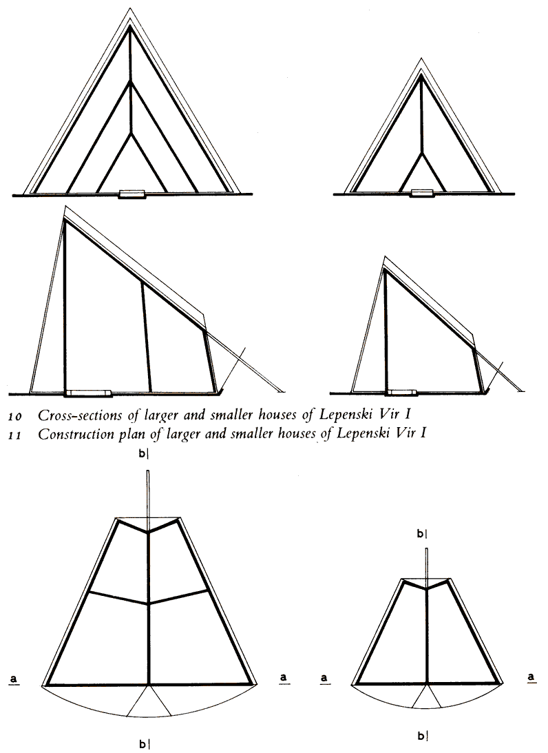
This does not seem to accord with either the diagram that is provided in the book by Srejović for the cross sections and plans (see diagram at left), nor with the attention to mathematics so in evidence by the inhabitants of the site.
There are two problems here:
Close examination shows a discrepancy between the layout of the foundation for house No 37 from Lepenski Ia and the cross-sections given on page 61 in terms of the position of the pairs of side posts.
On Figure 8, the foundation of house No. 37 is shown as a "small" house, which has a pair of posts placed, as noted above, at points 2/3 of the distance from the front to the back of the house, with another pair of posts on either side at the very front of the house, with a central post half way between these.
For "large" houses, the pairs of "side" posts are placed at 1/3 and 2/3 of the distance from the front to the back of the house.
But when we examine the cross sections, it is evident that the draftsperson has placed the side pair of posts not at the 2/3 and 1/3 points, but at either the end of the dwelling in the case of the "small" design, or at the end of the dwelling and at the 2/3 point in the case of the "large" version. It would seem that Srejović has been let down by others in this instance.
I've helped produce books myself, and it is a frustrating experience when others make the decision "that's close enough" without asking the person directly responsible for the integrity of a book. Once the book is published, it is too late. - Don
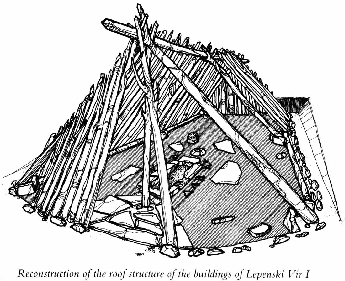
Photo: "Lepenski Vir" by Dragoslav Srejović 1972
Reconstruction of the roof structure of the buildings of Lepenski Vir I. Note the position of the three posts at the front, and the pair of posts on the sides, set at the standard 2/3 distance from the front of the dwelling, agreeing with the text but not the apparently erroneous cross sectional diagrams and plans above. However the artist has placed the two angled posts at the front at a smaller angle than 60°, and the ridge pole appears to slope at a fairly shallow angle.
Another problem is that of rigidity and whether the houses would actually remain upright given these simplistic construction methods. There would be a force component downwards from the front of the house to the rear, which if not allowed for, would mean that the roof would simply not stay up given the way the diagram shows the poles and other sticks which form the backbone of the roof.
It would seem to me that the easiest way to take care of the tendency of the roof to collapse backwards would be to extend the ridgepole to ground level (outside the house at its rear) and rest it on a solid foundation such as a big flat rock, or the bedrock of the terrace, since many of the houses were in fact dug into the hillside in any case. In fact, the diagrams showing the roof sections and plans show just such an extension of the ridgepole to ground level, though it is never mentioned in the text.
Another way to take care of the problem would have been to affix, as all modern roofs do, a diagonal member across the other parts of the roof on the inside, and fasten it securely (by lashing, for example) to all the elements of the roof, but especially the ridge pole and the more solid posts of the sides of the roof.
- Don
This would give a very simple roof since the skeleton of the superstructure, which usually consisted of three pairs of poles (three pairs for the larger houses, only two pairs for the smaller ones - Don) and the centre post, could easily be supplemented by ranging thin wooden props at the angles. It must, however, be pointed out that such a primitive roof construction does not tally with the foundation which is solidly built and perfectly proportioned, and some other reconstruction of the house may therefore be more correct. Be that as it may, the foundation would appear to have determined the architecture of Lepenski Vir, the building always begins from the inside, from the foundation, and remains wholly dependent on it.
The first plan of the settlement shows that in phase Ia the whole area of the horseshoe-shaped shelf was already conceived as the interior of a gigantic house which had for its frontage the curve of the Danube bank and at its rear the steep cliffs of the Koršo hills. The contours of the sides of the settlement were less well defined, but the settled area was nonetheless quite clear and simple; by the bank the terrain is level or only insignificantly concave, but in the centre, where there is a wide tongue of land, it rises accordingly.
Lepenski Vir la covered an area of 1 500 square metres, and this had to serve its hundred or so inhabitants. The living space available to them had therefore to be so organized as to avoid a feeling of restriction. They were thus compelled when building their settlement to economize on space like misers, to profit by every detail and every free corner; at the same time taking care that their freedom of movement was not unduly restricted.
The first plan of the settlement (1a) shows that all these basic requirements were met. By skilful arrangement of the houses an open space was formed in the centre of the settlement and numerous means of communication were created which showed how adaptable was the terrain, gave depth to the whole area, and controlled the position and size of all the houses.
The nature of the site occupied during phase Ia imposed a number of restrictions. Since the settlement was literally cut off from its surroundings, room had to be found in it not only for dwellings, but also for shrines, graves and every other individual or collective function of everyday life. The newly settled area, however, was not large. Lepenski Vir la covered an area of 1,500 square metres, and this had to serve its hundred or so inhabitants. The living space available to them had therefore to be so organized as to avoid a feeling of restriction. They were thus compelled when building their settlement to economize on space like misers, to profit by every detail and every free corner; at the same time taking care that their freedom of movement was not unduly restricted.
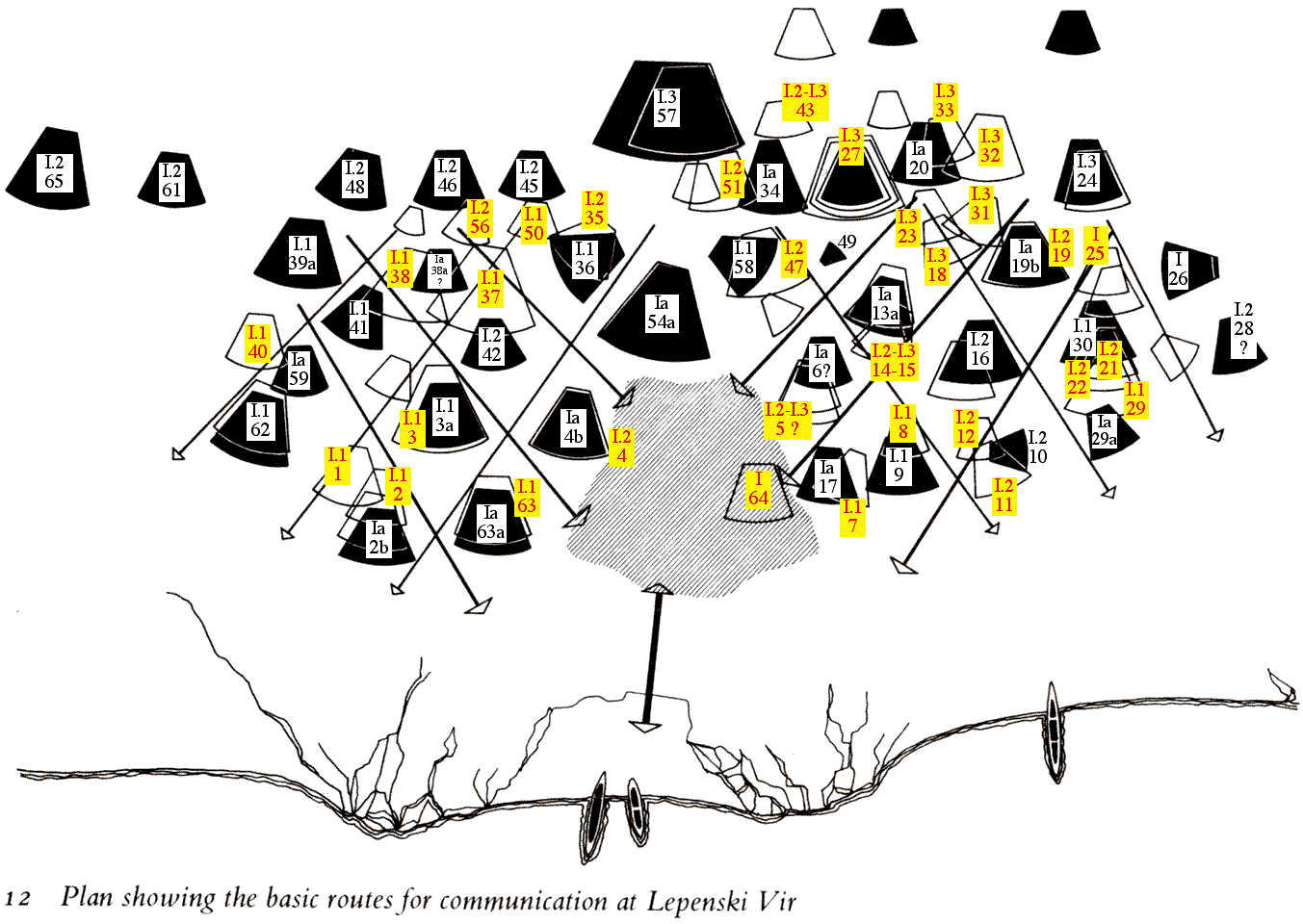
Photo: after "Lepenski Vir" by Dragoslav Srejović 1972, with additions after Clive Bonsall. It should be realised that although Srejović recognised stages Lepenski Vir Ia through to Ie, later investigators have divided Lepensk Vir I into just three: Lepenski Vir I.1, I.2, and I.3. I have used Bonsall's interpretation where applicable, and that of Srejović (in this case usually Ia) where Bonsall has not identified a particular site, but Srejović has. The original diagram appears to use black infill for those houses identified by Srejović as being from Lepenski Vir Ia, and blank outlines where the houses are identified by Srejović as being from some other part of the Lepenski Vir I culture. I have used yellow backgrounds and red text for the blank outline house sites, and white backgrounds and black lettering for the black infill house sites - Don
Along the terrace by the river bank the shelf is about 7 metres lower than the upper terrace where the houses are 66.27 metres above sea-level. These differences in level in the inhabited area were overcome by ramps, alleys and steps which led either down to the 'market-place' or up towards the central house. Because of the horseshoe-shape of the shelf all approaches were oriented either SE-NW or SW-NE. These intersecting lines of communication formed a framework which determined the position of all the houses. However, since ramps and steps did not always follow straight lines, but frequently curved in following the contours of the terrain, the free spaces between these intersections were not of the same size. This explains the variation in size of the houses of the settlement of Lepenski Vir 1.
Because of the way the ground slopes, the backs of many of the houses were dug into the shelf. Whereas in the western section of the settlement such excavations sometimes reached a depth of one metre (e.g. house No. 34), the houses erected on the level ground near the Danube bank needed no excavation (e.g. houses Nos. 2b, 62a, 63a and 17). All the houses, with the exception of two in the centre (Nos. 36 and 58) are orientated along the diagonal axis of the shelf in an east-west direction, so that they all faced the river. In the centre is the largest house (54a). It backs on to the shelving shore and its high frontage closes and powerfully accentuates the open space of the central 'market-place'. Houses Nos. 36 and 58, which flank the central house in a radial manner, are oriented like the lateral axes of the shelf towards the south-east, or north-east. The 'market-place' with these three central houses forms the nucleus of the settlement in relation to which all other buildings are sited and all means of communications are centred relative to it.
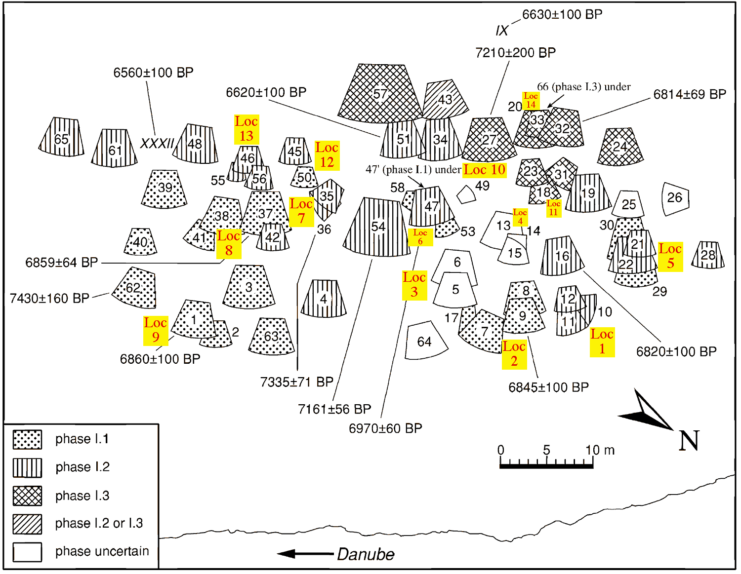
General plan of the Lepenski Vir I habitations, showing house locations "L", as well as radiocarbon dates of some houses based on charcoal samples. The radiocarbon ages of houses 36, 37 and 54 are weighted means of several measurements. The locations and ages of two Lepenski Vir II houses, IX and XXXII, are also shown.
Map after: Bonsall et al, 2000, 'Stable Isotopes, Radiocarbon and the Mesolithic-Neolithic Transition in the Iron Gates', Documenta Praehistorica XXVII. (Electronic reprint kindly sent to me by Dr Clive Bonsall.) Locations marked in red on a yellow background after 'The Iron Gates Mesolithic', Radovanović, 1996.
Along the terrace by the river bank the shelf is about 7 metres lower than the upper terrace where the houses are 66.27 metres above sea-level. These differences in level in the inhabited area were overcome by ramps, alleys and steps which led either down to the 'market-place' or up towards the central house. Because of the horseshoe-shape of the shelf all approaches were oriented either SE-NW or SW-NE. These intersecting lines of communication formed a framework which determined the position of all the houses. However, since ramps and steps did not always follow straight lines, but frequently curved in following the contours of the terrain, the free spaces between these intersections were not of the same size. This explains the variation in size of the houses of the settlement of Lepenski Vir 1.
Generally speaking, in all levels of settlement I the central house was the largest, for its frontage closed the 'market-place', about 10 m. wide. In phase la the foundation of the central house covered an area of 30 sq. m. and its frontage was 7 m. wide and about 5.5 m. high.
Note, Srejović is saying here in effect that the angles of the two front side posts are at 58°. For 60° the height would be 6 m.
Calculations for the areas and the resulting front and height dimensions give, (see below for more detailed treatment of other areas, and using 60° to obtain the front height, and assuming an equilateral triangle as the basic design, a reasonable assumption)
For 30 sq. m. the width at the front is 8.4 m and the height is 7.2 m.
It is not clear why there is this discrepancy in width, because Srejović would have actually measured both the width and the house foundation area. - Don
Since the two neighbouring houses were set back and had a different orientation, the central house dominated the area, standing out above all the other buildings of the settlement. Though the width of its frontage was approximately equal to that of the 'market-place', the open space in the centre of the settlement was not sealed off but had two main 'streets' each about 2.5 m. wide branching off from beside the facade of the central house and leading upwards towards the north-western and south-western flanks of the shelf.
All the other main lines of communication had an approximately similar orientation as the two 'main streets' and each led towards the 'market-place'. The subsidiary roads which did not lead towards the 'market-place' and the central house but towards the river bank cut diagonally across the main communications. Whereas the latter were designed as broad, gentle ramps, the subsidiary links as a rule took the form of very narrow paths provided with short, steep steps. They always ran along the sides of the houses, whereas the ramps bordered their frontages.
Both categories tended to vary in width throughout their length; the width of the ramps gradually contracted from the 'market-place' to the highest terraces and the subsidiary paths with steps became narrower from the bank towards the raised back of the shelf The houses, moreover, are for the most part larger in the central parts of the settlement than near the bank and on the flanks of the shelf. (This accords with common experience elsewhere. Who has not noticed that a path towards the wilderness gradually decreases in width and in ease of use as you go further into the unknown?)
The houses were built in four basic sizes, with foundations of approximately 5.50, 9.50, 17 and 28 sq. m. and probably varying in height from 1.8, 2.4, 2.9 to 4.1 m.
Note that these heights are at great variance with the 60° standard that we would expect on the basis of mathematics, or the 58° implicit in the value given earlier by Srejović for the foundation of the central house which covered an area of 30 sq. m. (or 28 sq. m., take your pick. )
Calculations for the areas and the resulting front and height dimensions give:
(using 60° to obtain the front height, and assuming an equilateral triangle as the basic design, a reasonable assumption)
For 5.5 sq. m. the width at the front is 3.6 m and the height is 3.1 m.
For 9.5 sq. m. the width at the front is 4.7 m and the height is 4.1 m.
For 17 sq. m. the width at the front is 6.3 m and the height is 5.5 m.
For 28 sq. m. the width at the front is 8.1 m and the height is 7.0 m.
For 30 sq. m. the width at the front is 8.4 m and the height is 7.2 m.
For 35 sq. m. the width at the front is 9.0 m and the height is 7.8 m.
For 36 sq. m. the width at the front is 9.2 m and the height is 7.9 m.
Note also that this last value of 4.1 m for the height of the 28 sq. m. foundation area ("with foundations of approximately 5.50, 9.50, 17 and 28 sq. m. and probably varying in height from 1.8, 2.4, 2.9 to 4.1 m)" does not even match with the value of 5.5 m. in the data for the large house Srejović gives earlier, (? He seems to refer to this house as having a floor area of 28 and 30 sq. m. in different places.)
Specifically, earlier he says: In phase la the foundation of the central house covered an area of 30 sq. m. and its frontage was 7 m. wide and about 5.5 m. high.
However simple calculations give values of 8.4 for the width and 7.2 for the height for a dwelling of this area. As I have noted above, it is not clear why there is this discrepancy in width, because Srejović would have actually measured both the width and the house foundation area.
Later in the book, when talking about house No. 57 from Lepenski Vir Ie, he states that it has a frontage of 9 m and an area of 36 sq. m. As can be seen from my figures above, this is pretty much spot on (given the inevitable approximations of measurement in the field) for the calculated values, where a house with foundations having an area of 35 sq. m. has a width of 9 m. - Don
The smallest houses (from 5.5 to 9.5 sq. m.) were for the most part on the level land near the bank or on the last, highest raised, terrace of the shelf; the largest (28 sq. m.) occupied a central position in the settlement. Since the height of a house depended on the size of its foundation, this meant that the verticals which indicated the height of the frontage grew in accordance with the height of the bank towards the central rise. There were some irregularities but only when specific features of the terrain called for them.
Back to Don's Maps
Back to the Iron Gates
Lepenski Vir Ib-e, II, III