Back to Don's Maps
Back to the Iron Gates
 Proto Lepenski Vir and Lepenski Vir Ia
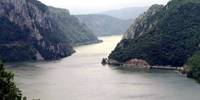
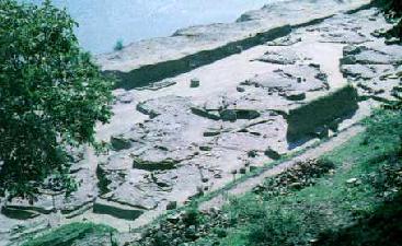
Lepenski Vir is the name of the great whirlpool in the middle of Djerdap, the Iron Gates Gorge, and the nearby horseshoe shaped shelf between the right bank of the Danube and the steep cliffs of the Koršo hills. Lepenski Vir is a Mesolithic site - that means middle stone age, in this case 8 000 years before the present, after the ice had begun to melt from the glaciers which covered so much of the Northern Hemisphere. It is an open air site, not a rock shelter. It is noted for the trapezoidal houses which had one of the first types of concrete as their foundations. They inhabitants ate fish, aurochs, deer and water birds. Professor Dragoslav Srejović excavated the site of Lepenski Vir. The prehistoric settlement was built on the sunny right bank of the Danube, between the steep slopes of the Koršo hills and the spring high water mark on the low porphyritic rocks which stretch down to the river.
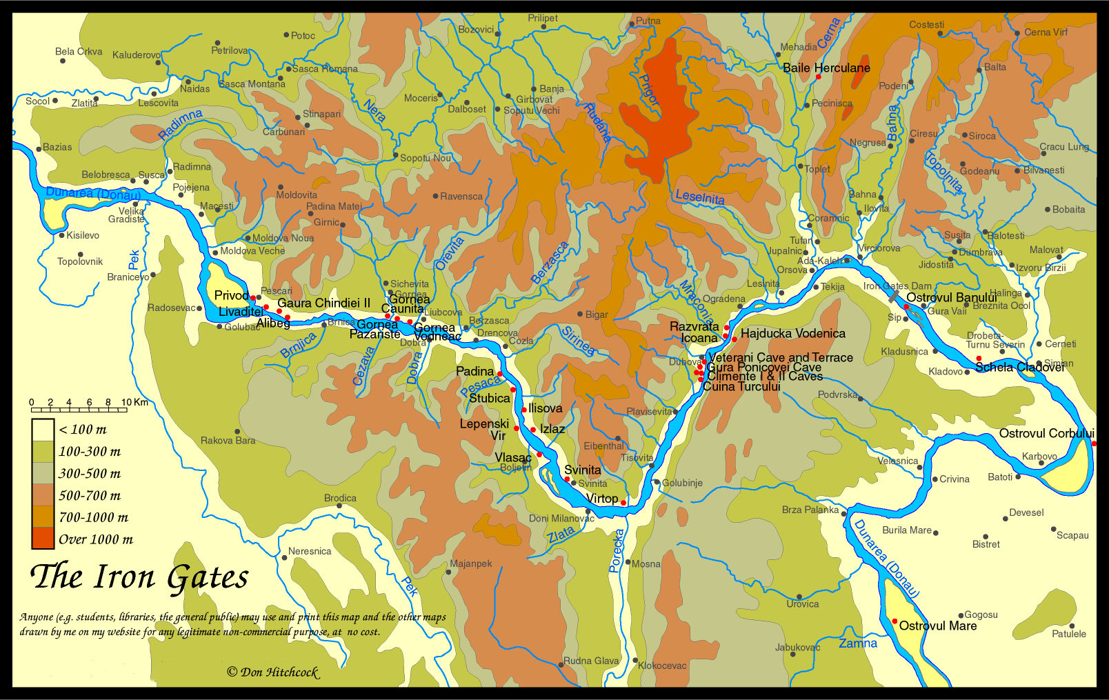
Map of the Iron Gates region, with the position of Lepenski Vir marked.
Photo: Don Hitchcock 2014
Much of this text is adapted from "Lepenski Vir" by Dragoslav Srejović 1972
Dragoslav Srejović was a giant. This book is a masterpiece, and deserves a wider audience.
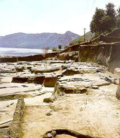
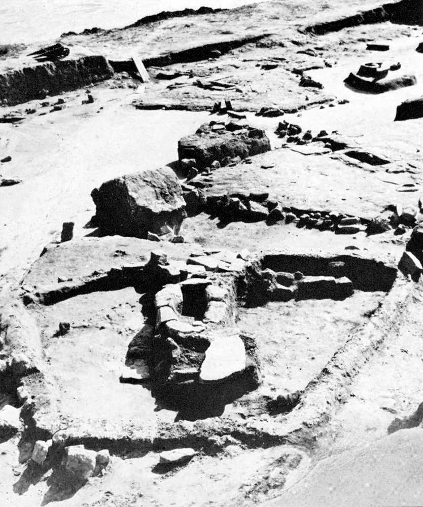
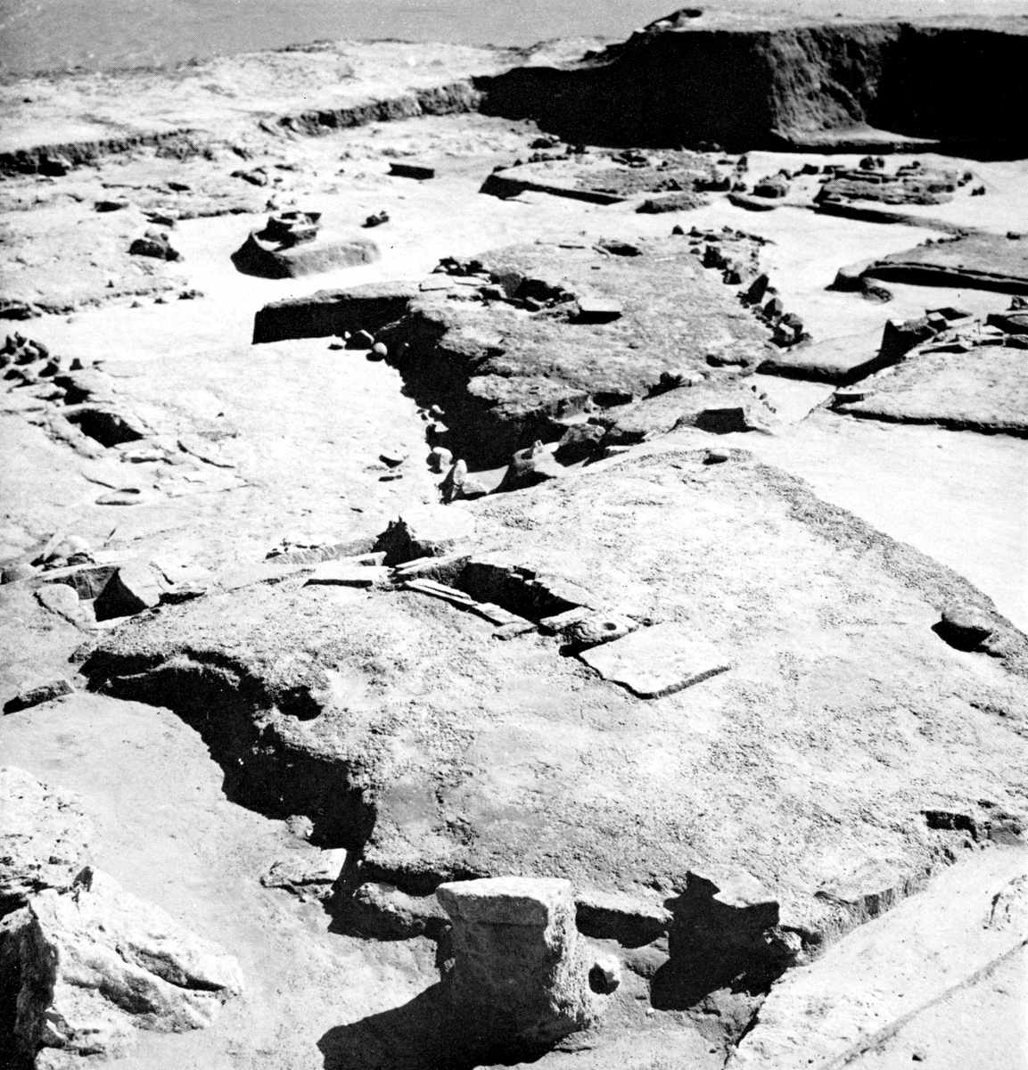
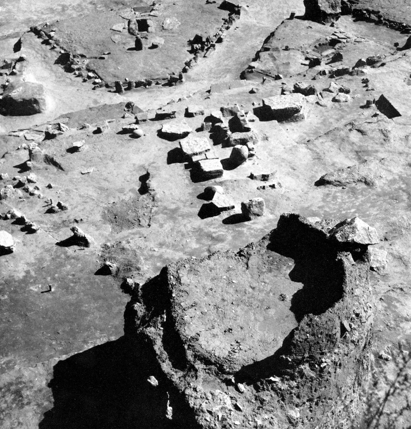
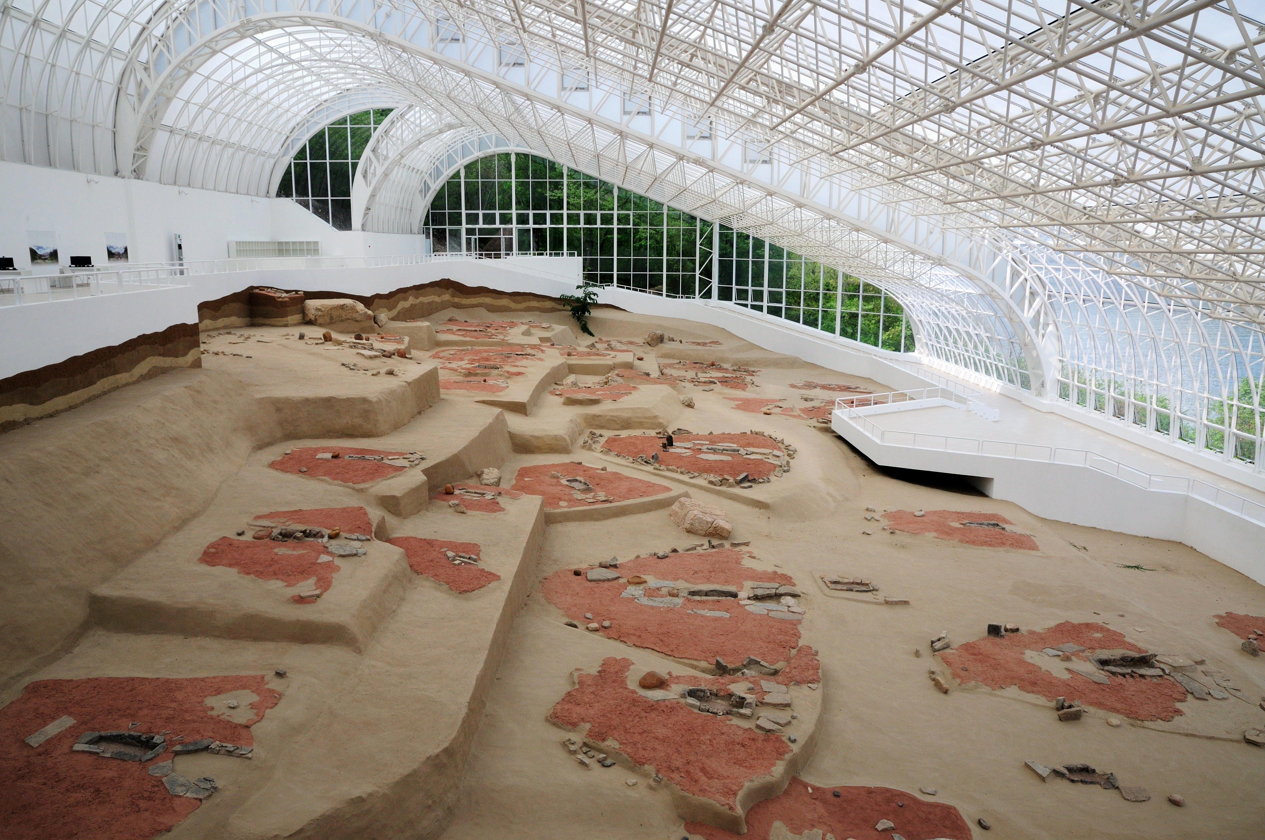
Photo of the excavation area at Lepenski Vir, on the right bank of the Danube River, in present day Serbia.
Photo: http://www.cimec.ro/livingpast/nr1/boroneant/schela_cladovei/arta/fig20.htm
Click on the image for a larger view.
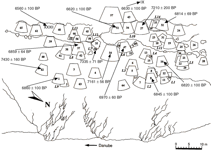
General plan of the Lepenski Vir I habitations, showing house locations "L", as well as radiocarbon dates of some houses based on charcoal samples. After Radovanović, 1996, with acknowledgement to Boric 1999 and Bailey 2000. The radiocarbon ages of houses 36, 37 and 54 are weighted means of several measurements. The locations and ages of two Lepenski Vir II houses, IX and XXXII, are also shown. From: Bonsall et al, 2000, 'Stable Isotopes, Radiocarbon and the Mesolithic-Neolithic Transition in the Iron Gates', Documenta Praehistorica XXVII.
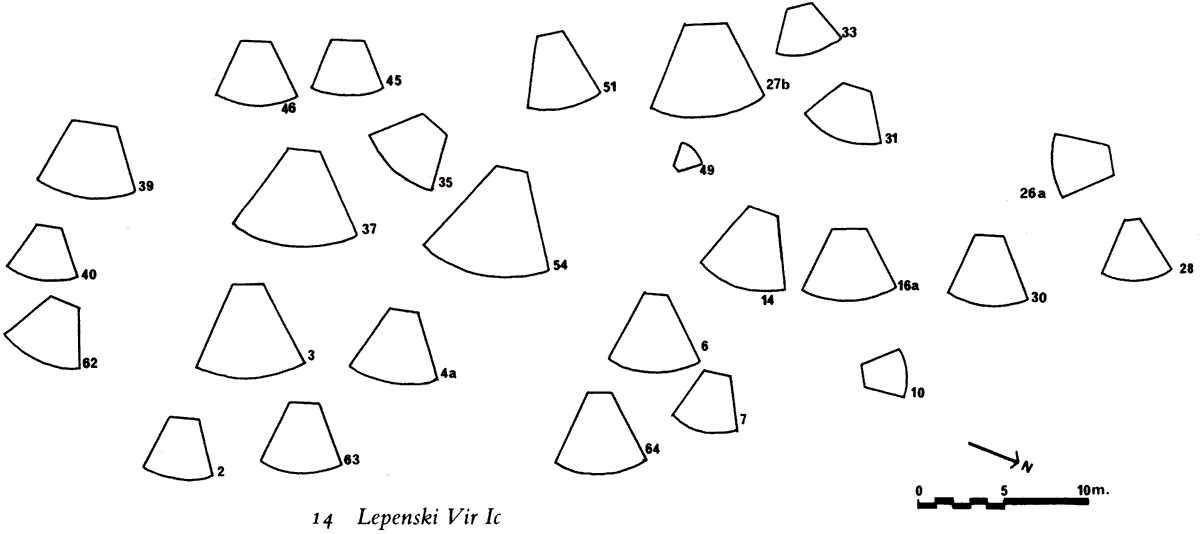
Below, some information about the Lepenski Vir site from Lepenski Vir Ib on. Should you wish to see the earlier settlements, go to the introduction.
Lepenski Vir Ib
(adapted from "Lepenski Vir" by Dragoslav Srejović 1972)
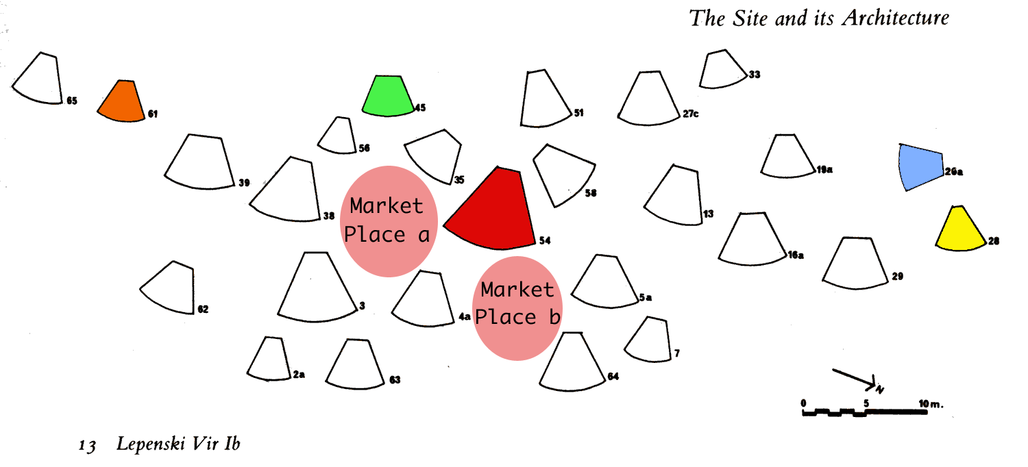
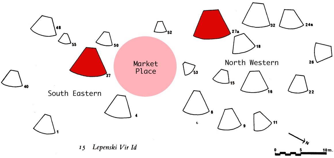
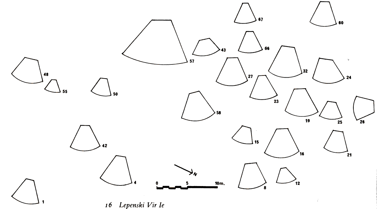
Lepenski Vir Ib showing the disposition of the houses and their plans and aspects.
Note that the important house No. 54 has been coloured in red, house No. 28, the 'sanctuary under the rocks' has been coloured yellow, house No. 26 which is oriented north south is coloured blue, house No. 45 for which between the hearth and the stone 'table' is an altar carved in the semblance of a fish is coloured green, and house No. 61 which had a grave within it is coloured brown.
My own interpretation is that there are two areas which might have been meeting places or market places, or areas for public ceremonies, shown here as 'Market Place a' and 'Market Place b', coloured pink. Both are on major throughways, and could easily be thought of as one space with two lobes connected by a thoroughfare. - Don
Photo: "Lepenski Vir" by Dragoslav Srejović 1972
The first great rebuilding of the settlement, carried out in the course of the next phase, Lepenski Vir Ib, did not add anything new to the external appearance, nor to the arrangement of houses. Twenty-two newly built and four renovated houses only extended the former communications, insignificantly widening the framework of the settlement which now embraced an area of about 1700 sq. m.
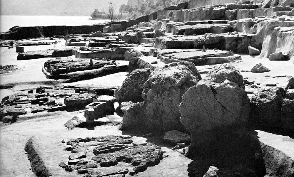
Lepenski Vir I - the south eastern part of the settlement, seen from the west. In the foreground can be seen house No. 35 (Lepenski Vir Ib) which was built on the foundation of house No. 36 (Lepenski Vir Ia).
Photo: "Lepenski Vir" by Dragoslav Srejović 1972
The central house (No. 54) was extended and restored from the foundations and a new house (No. 35) was built on its south-eastern flank with almost the same orientation, however, as house No. 36, on whose ruins it was placed. It is characteristic that the other newly-built houses almost entirely cover the foundations of the houses occupied during the preceding phase and that they maintain their orientation. That meant that the backbreaking work of digging up the terrain was avoided during their construction.
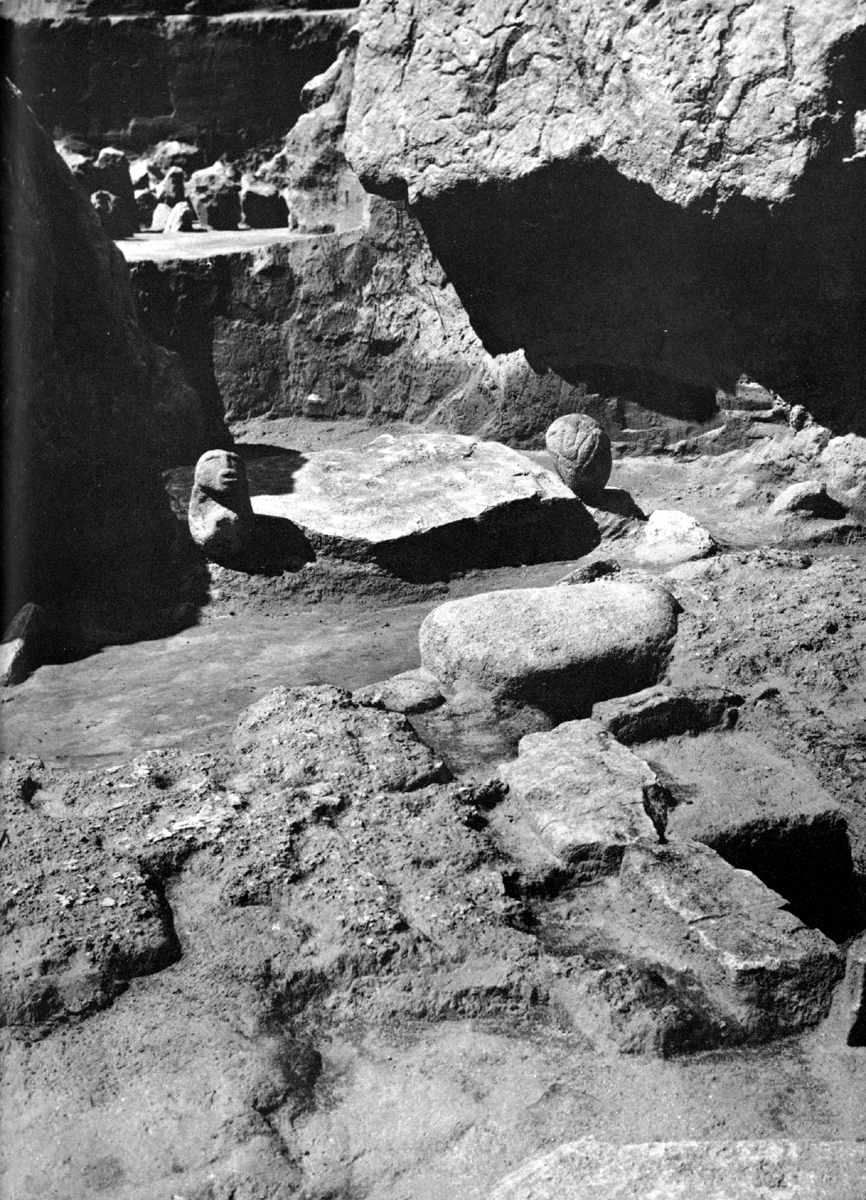
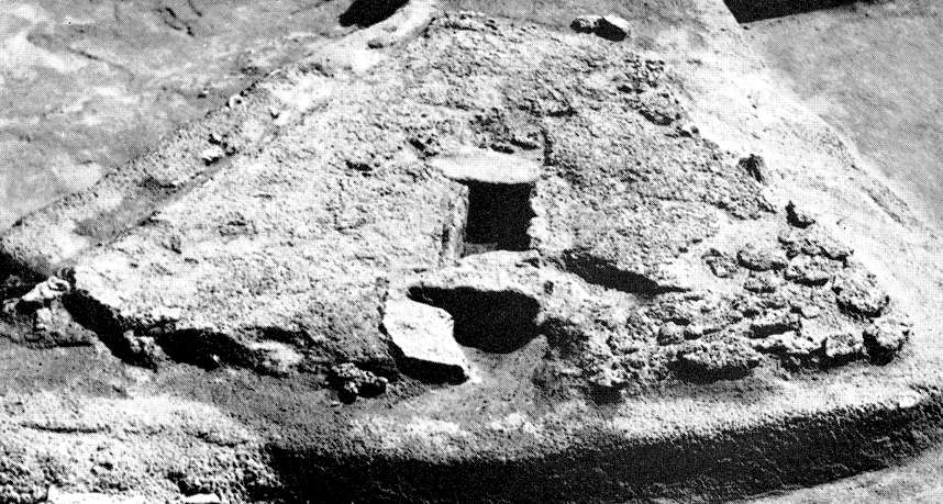
Lepenski Vir I - view of the settlement from the north east. In the foreground is house No. 28 and the 'sanctuary under the rocks'.
Photo: "Lepenski Vir" by Dragoslav Srejović 1972
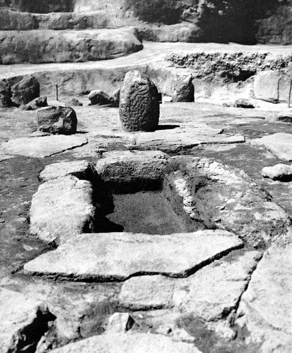
Normally the buildings had their frontages turned towards the river, but on the northwestern wing of the shelf one of the newly built houses (No. 26) was oriented in a north-south direction. The exceptional position of this house, however, was due to the great mass of broken rocks which marked the boundaries of the settlement on the northern side of the shelf. By the erection of one more building (No. 28) in the vicinity of these stones, which nature had shaped like a monumental sculpture, they became a part of the settlement. This is where the 'sanctuary under the rocks' is incorporated into the building.
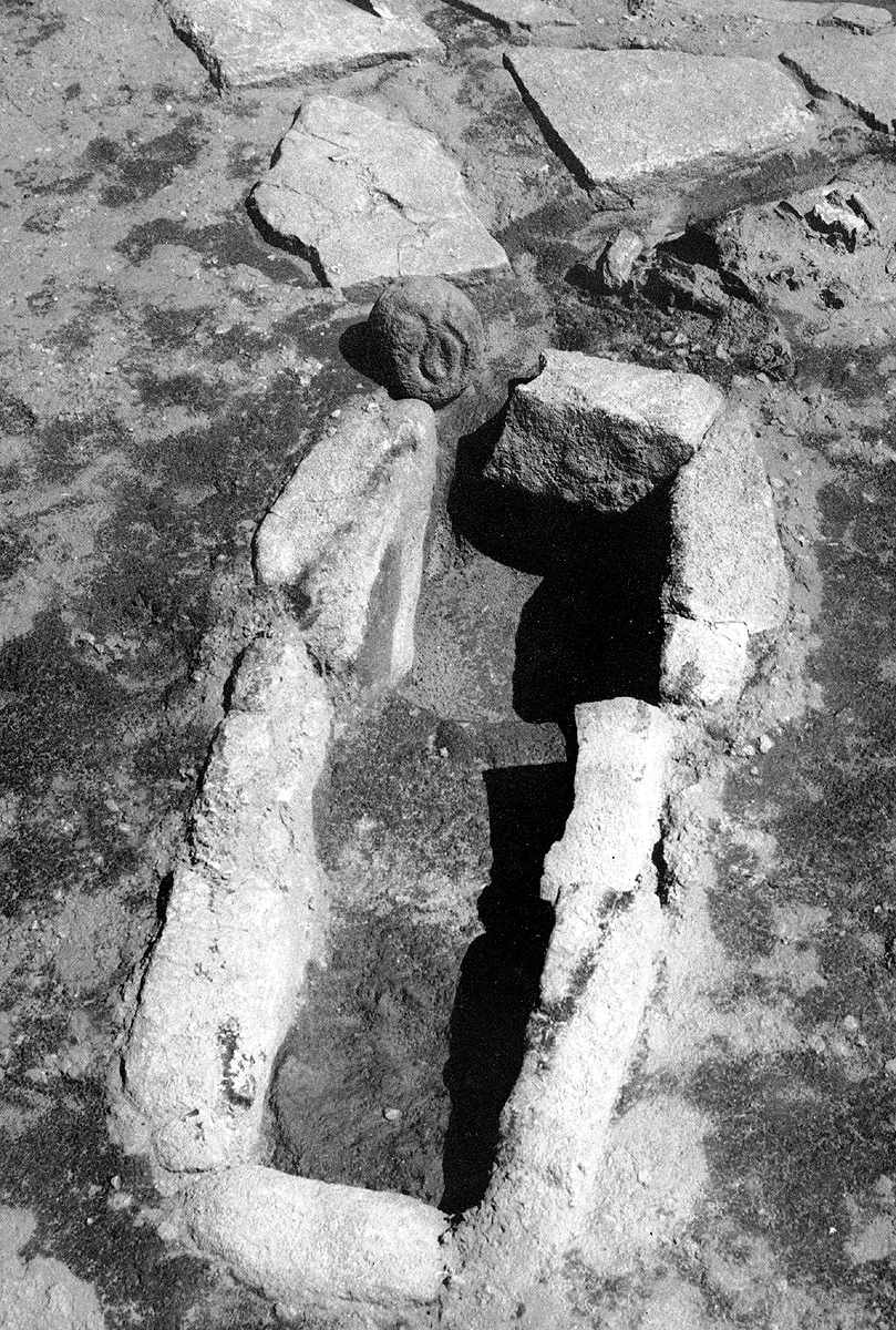
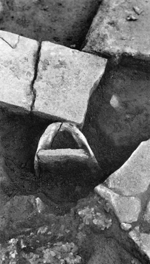
'The sanctuary under the rocks', house No 28 Lepenski Vir Ib. Behind the hearth, in the rear wall of the house, is a large stone 'table' flanked by one representational and one ornamental sculpture.
Photo: "Lepenski Vir" by Dragoslav Srejović 1972
This example shows that the builders of Lepenski Vir Ib ventured to take advantage of even the most unfavourable aspects of the terrain and to include them successfully in their architectural scheme.
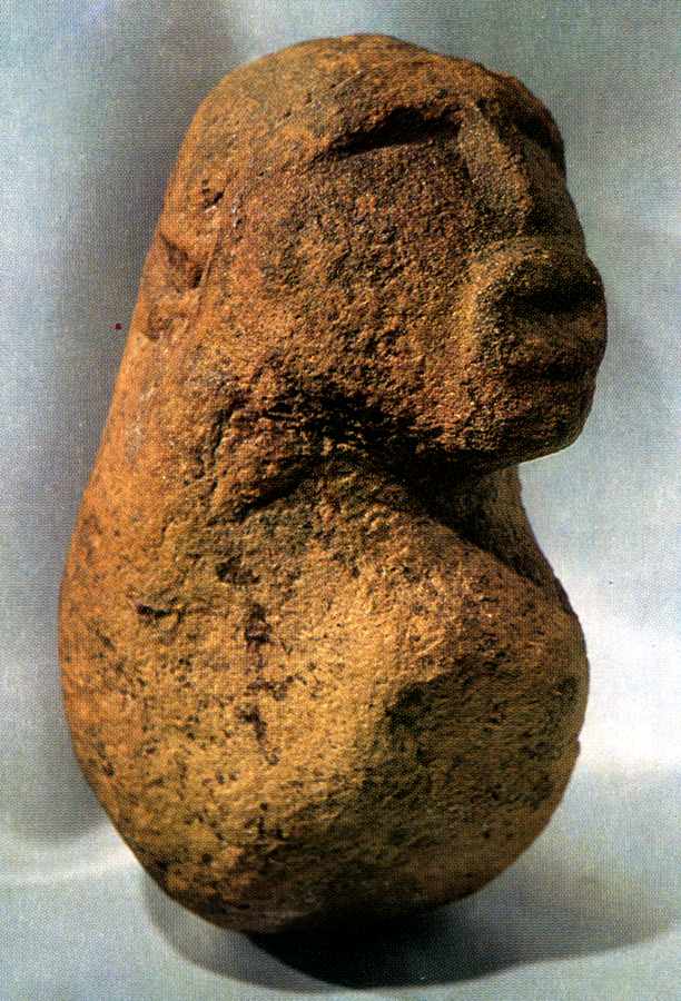
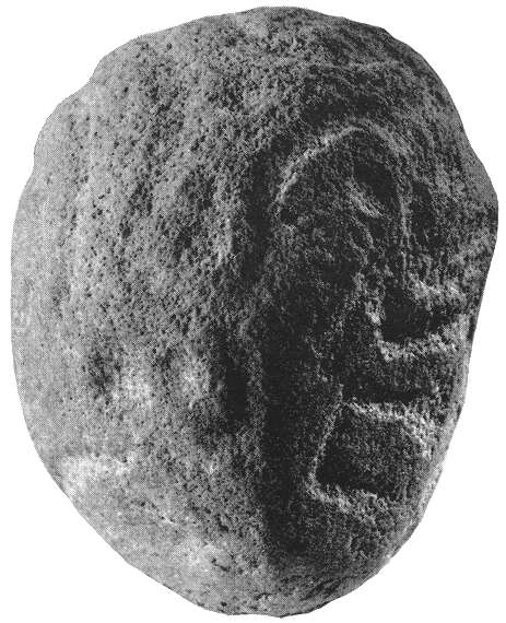
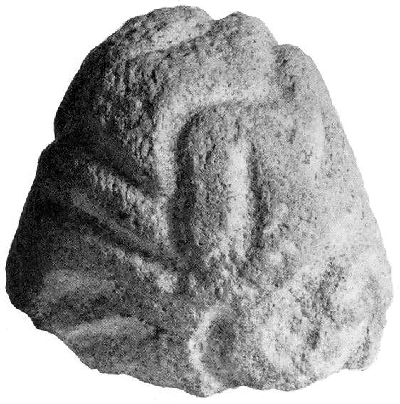
Sculpture from the 'sanctuary under the rocks' (Lepenski Vir Ib).
This sculpture of coarse-grained yellow sandstone found in the 'sanctuary under the rocks' is carved in a markedly naturalistic style without the fish attributes so many other sculptures at Lepenski Vir exhibit.
Only the head is clearly shaped, and then only its most striking features: heavy eyebrows, long nose, and large thick lips.
Photo: "Lepenski Vir" by Dragoslav Srejović 1972
The houses built during phase Ia had a compact plan and a uniform internal space. The thresholds, the hearth construction and the rounded boulder placed symmetrically in relation to the frontage divided the house into two equal parts and discreetly accentuated its central point. Only in two cases, namely in houses 36 and 65, was this clear, eminently comprehensible, scheme partially destroyed by the insertion of a large boulder behind the hearth. At first sight this would appear to be both an arbitrary and a non-functional arrangement. The foundations of the houses built during phase lb show what the builder wished to attain by the new positioning of this boulder.
Note that house No. 65 is placed by Srejović as belonging to Lepenski Vir Ib as well as Lepenski Vir Ia so far as inclusion in the maps of the stages is concerned (meaning no doubt that the house was built in the Ia phase but was not demolished, and continued to be occupied in the Lepenski Vir Ib culture). Note also that Radovanović places both the houses 36 and 65 in Phase 2. - Don
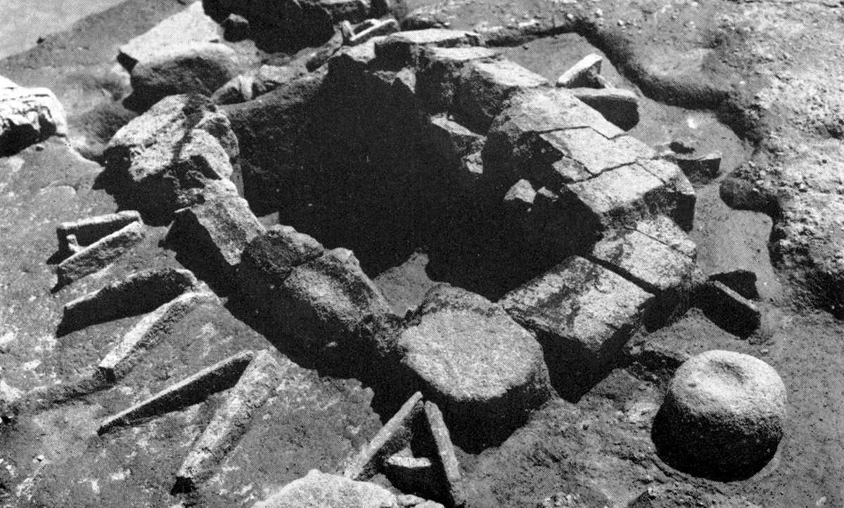
Hearth in the central large house No. 54 (Lepenski Vir Ib and Ic). Behind the hearth construction two stone sculptures, of which one is preserved in fragments, are embedded in the floor.
Photo: "Lepenski Vir" by Dragoslav Srejović 1972
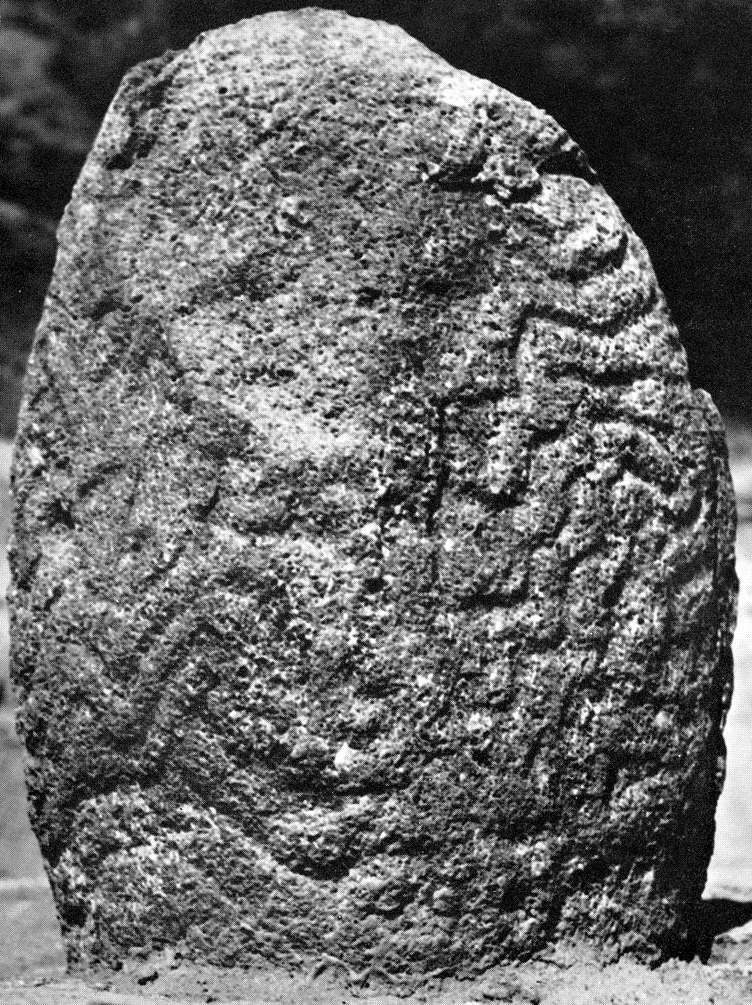
Altar from the sanctuary of house No. 54 (Lepenski Vir Ib).
If viewed from the front of the sanctuary as shown in the photograph above, the undulating furrows on this sculpture recall a knot of serpents, whilst if they are seen from the rear wall, as shown here, they could be a representation of turbulent torrents falling in cascades over the rocks.
Photo: "Lepenski Vir" by Dragoslav Srejović 1972
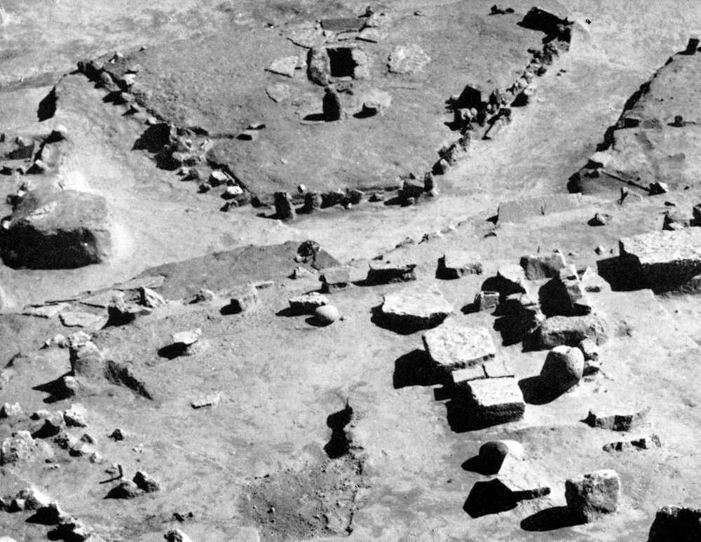
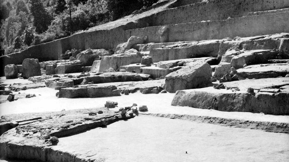
The complete foundations of the central large house No. 54 (Lepenski Vir Ib and Ic) may be seen here behind the central large house of Lepenski Vir II (No. XLIV). It is not an accident that the two are placed in a similar location, in a commanding position over the rest of the settlement.
Photo: "Lepenski Vir" by Dragoslav Srejović 1972
In the foundations of the newly-built houses we find the usual stone thresholds, hearths and rounded boulders with circular depressions, disposed in the customary manner. To them, however, two fresh elements are added: stone 'tables' and sandstone sculptures, which divide up the internal space and make it possible to get a clear understanding of its key functions. The placing of these new elements is approximately the same in all the buildings.
Lepenski Vir I - the south eastern part of the settlement. In the foreground is house No. 45, Lepenski Vir Ib, in which the sanctuary is marked only by a stone 'table' and an altar (see close up further down this page) embedded in the reddish limestone mass of the floor.
Photo: "Lepenski Vir" by Dragoslav Srejović 1972
In the reconstructed central building six wide stone flags or 'tables' are inset, so placed that they divide the superficial elliptically shaped area, along whose longer axis lie the hearth and the boulder which in this specific case is carved as a wide, shallow receptacle. Between these stone 'tables' and behind the hearth are placed two stone sculptures, one of which is 62 cm. high. Their disposition is such as to form a raised 'portal', the logical conclusion of a new, independent space organized on a horizontal axis. Since the stone 'tables' are set almost level with the floor and the verticals, represented by the sculptures, do not exceed a height of 60 cm., (they are embedded in the foundations, so even the 62 cm sculpture is lower in height than 60 cm. - Don) the compactness of the foundation is not destroyed, but by the use of these new elements the interior of the house is divided into individual sections with specific functions.
The hearth in house No. 45, Lepenski Vir Ib; between it and the stone 'table' is an altar carved in the semblance of a fish.
Photo: "Lepenski Vir" by Dragoslav Srejović 1972
The hearth with the receptacle surrounded by the stone 'tables' and the sculptures is separated from the living-area and becomes the centre of a little sanctuary. This sacral area is not crudely divided from the living-space by any definite construction, but its limits are clearly visible in the foundation and must have been sufficiently in evidence to order movement within the house. The thresholds at the entrance clearly direct all communication towards the sides of the house and suggest movement in a circle around the sacral area, though it is accessible from all sides. The stone 'tables' have this terminal quality; possibly they could only be crossed in exceptional circumstances and only by certain privileged persons. Thus the sanctuary possessed its own area set apart from the living space.
Altar from house No. 45, Lepenski Vir Ib, carved in the likeness of a fish, possibly a carp.
Photo: "Lepenski Vir" by Dragoslav Srejović 1972
Like the house foundations and the settlement as a whole, the sanctuary was organized according to a definite plan. The most complete manifestation of this appears in the arrangement of the above-mentioned sanctuary of the central house. There, in an area of 7.5 sq. m., the hearth has an axial position and the real centre is represented by the stone receptacle with a decoration in relief. Since the width and height of the entrance are approximately equal to the width and length of the sanctuary, the whole sacral area at the moment of sunrise could be revealed in a cone of first morning light as far as the sculptures which are placed at its end. A characteristic feature is that the sculptures, being the only verticals in the sanctuary area, are never subjected to the axial symmetry which the hearth and the stone receptacle suggest. They are never placed along the axis of the hearth, but always asymmetrically behind the stone 'tables'. Such a position stresses their privileged function, and their independence in the plan of the sanctuary.
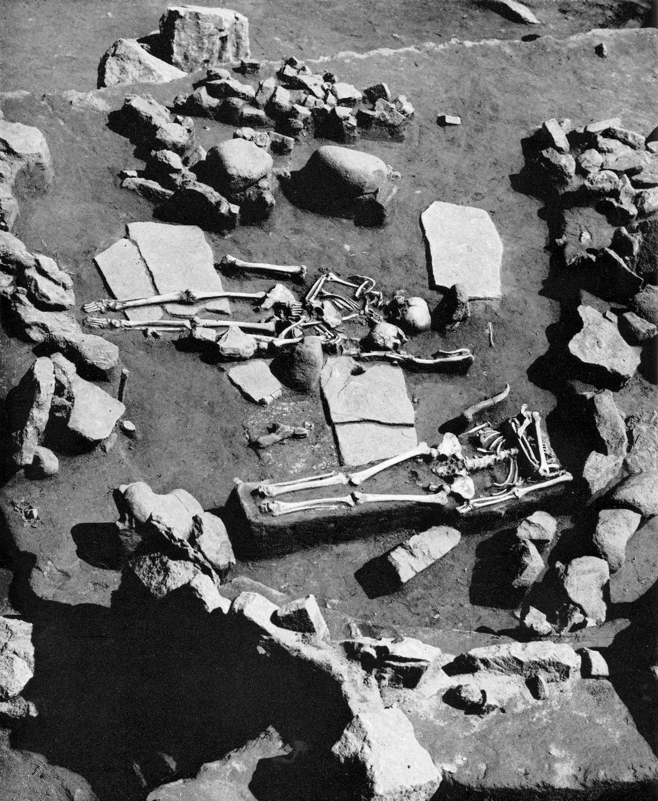
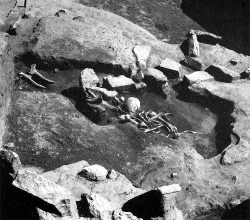
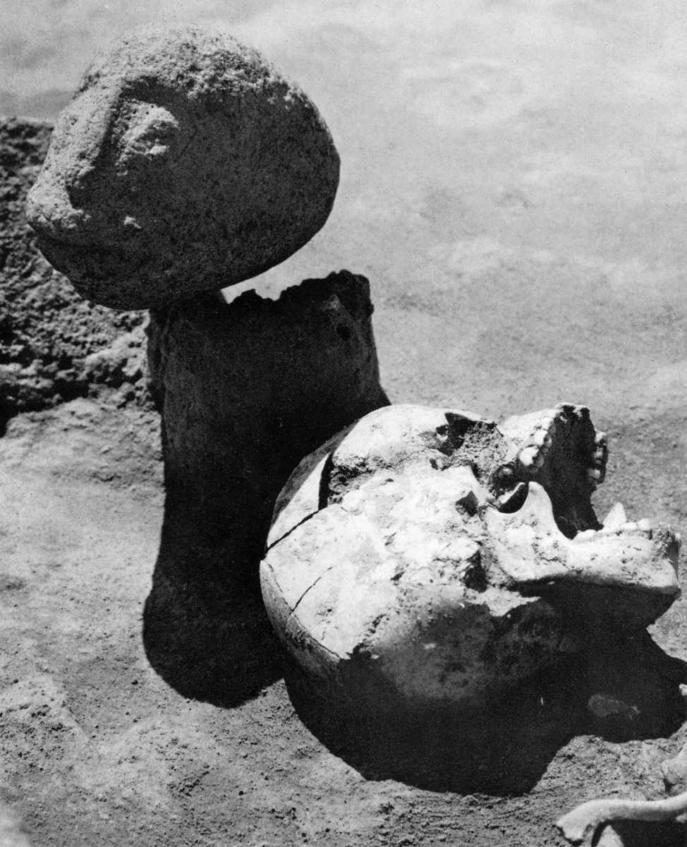
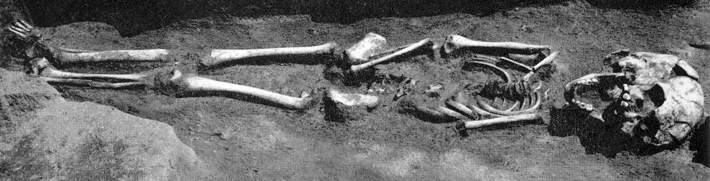
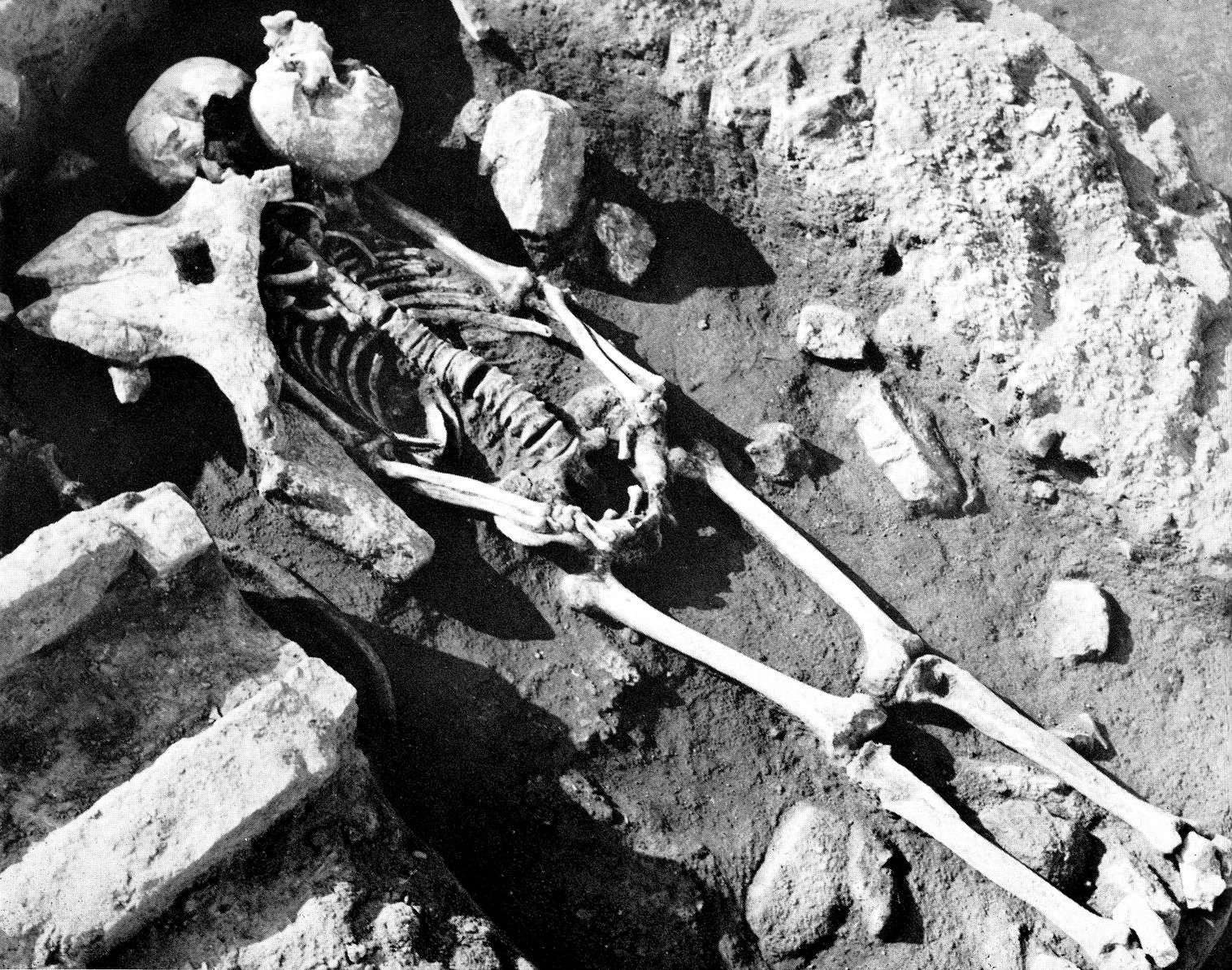
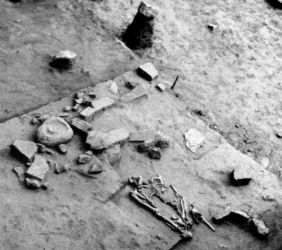
Skeletons found in the sanctuary of house No. 65 (Lepenski Vir Ib) between the hearth and the large aniconic boulder. (i.e. the stone was not sculpted into a recognisable image - Don)
The skeleton (foreground) without a skull was buried later and belonged to house No. XXXVI (Lepenski Vir II)
Photo: "Lepenski Vir" by Dragoslav Srejović 1972
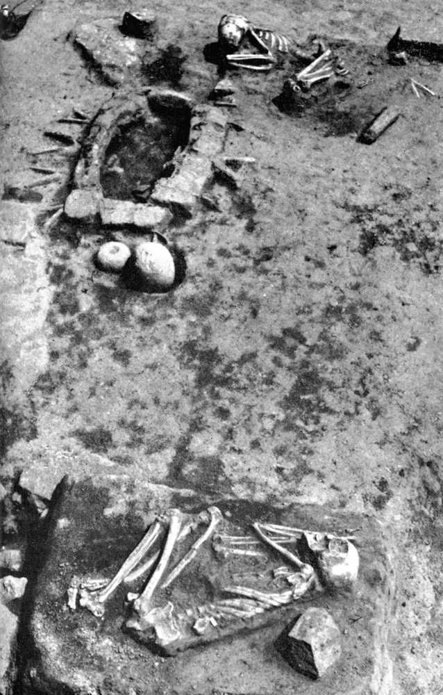
Grave in house No. 61 from Lepenski Vir Ib.
Photo: "Lepenski Vir" by Dragoslav Srejović 1972
The plan of the sanctuary in this developed form could not be coherently carried out in all the buildings because of variations in their size. In the majority of cases it is shortened in such a manner that the stone 'tables' do not frame the entire hearth but only its narrower side, around the stone receptacle and the sculptures. In this manner a miniature sanctuary is formed which, depending on the arrangement of the stone 'tables', can basically have a trapezoidal, triangular or, rarely, a square form. The relation between the sacral and the living area remains, however, approximately the same as in the central house, the sanctuary most often taking up about a quarter of the whole internal area.
Only one building (No. 28) is an exception to these rules. It was erected on the edge of the broken rocks already mentioned on the north-western periphery of the settlement. Its foundation covers 8 sq. m. and its internal space is determined by the developed plan of the sanctuary. Here, as in the central house, the stone 'table' with the sculptures is about one metre from the narrower side of the hearth, but because of the small dimensions of the building it merges into the rear wall and covers almost its entire width. Two sculptures, placed on either side of this stone 'table', even though in practice they are against the rear wall of the house, define the spiritual centre and the focus of the internal space. There is no living space in this case, which means that the building as a whole was designed as a sanctuary. All the other buildings have a double function, the area intended for magico-religious rites being linked with the area in which the inhabitants worked and lived. This linking of the secular and sacral areas in a single whole was so manifest that no specific architectural emphasis was necessary.
Photo: "Lepenski Vir" by Dragoslav Srejović 1972
Lepenski Vir Ic
(adapted from "Lepenski Vir" by Dragoslav Srejović 1972)
Lepenski Vir Ic showing the disposition of the houses and their plans and aspects.
Photo: "Lepenski Vir" by Dragoslav Srejović 1972
The number of newly-built houses is not large (only ten) and, in general, the buildings erected during phase Ib remained in use. The external form of the settlement did not change, but in its internal arrangement an uneasy merging which threatened to destroy its earlier unity is noticeable.
![]()
The central building lost its dominant position, for in its immediate vicinity, in the south-eastem sector of the settlement, a new house (No. 37) of imposing dimensions was built. On the other side of the settlement, the north-western part, another large building (No. 27b) was erected, so that within the limits of the settlement there are now three focal points in place of one.
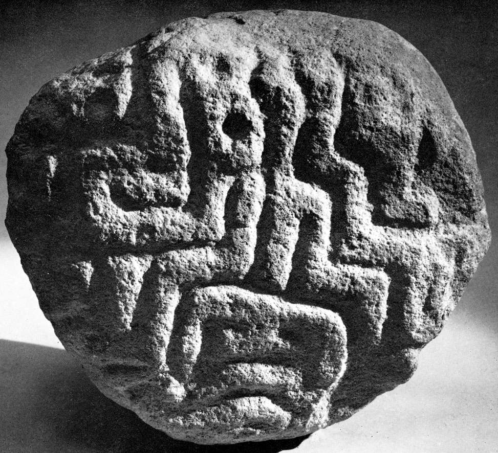
(Above and left) Views of the stone altars in house No. 37 (Lepenski Vir Ic) in relation to the hearth. The upper altar is an elliptical depression with lips at the sides (40 x 29 x 25 cm); its sides and bottom are decorated with a shallow design of concentric circles and broken meanders similar to a swastika motif. The lower altar (35 x 20 x 12 cm), found directly behind the hearth, is carved to represent a large eye, with fan-shaped lips on the shorter sides.
Photo: "Lepenski Vir" by Dragoslav Srejović 1972
The central house still dominates the whole area and so does the central 'market-place' but a characteristic feature is that in front of house No. 37 another free area - a new 'market-place' - was formed not much smaller than the central one. There was also a free area in front of No. 27b, for one of the main 'streets' was widened at the expense of the area formerly covered by house No. 58. This house flanked the central building to the north and therefore its demolition damaged the nucleus of the settlement and disorganized its radial communications. The central house was deliberately slighted and the space of the central 'market-place' disorganized. However, it wasjust this rejection of the earlier scheme which introduced more warmth and light into the living area. All the means of communication were widened and the interior of the settlement was discreetly broken into individual sections. Life was now concentrated around two additional new centres.
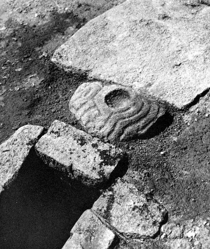
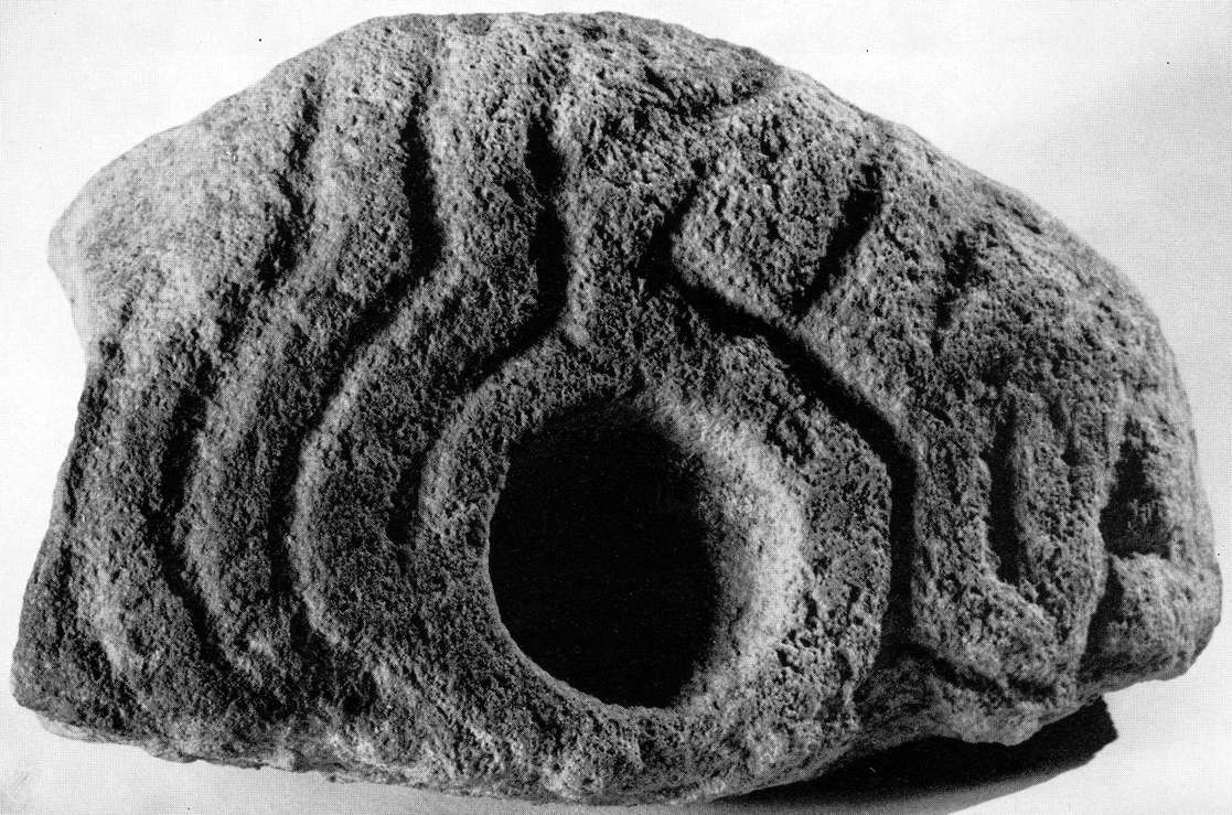
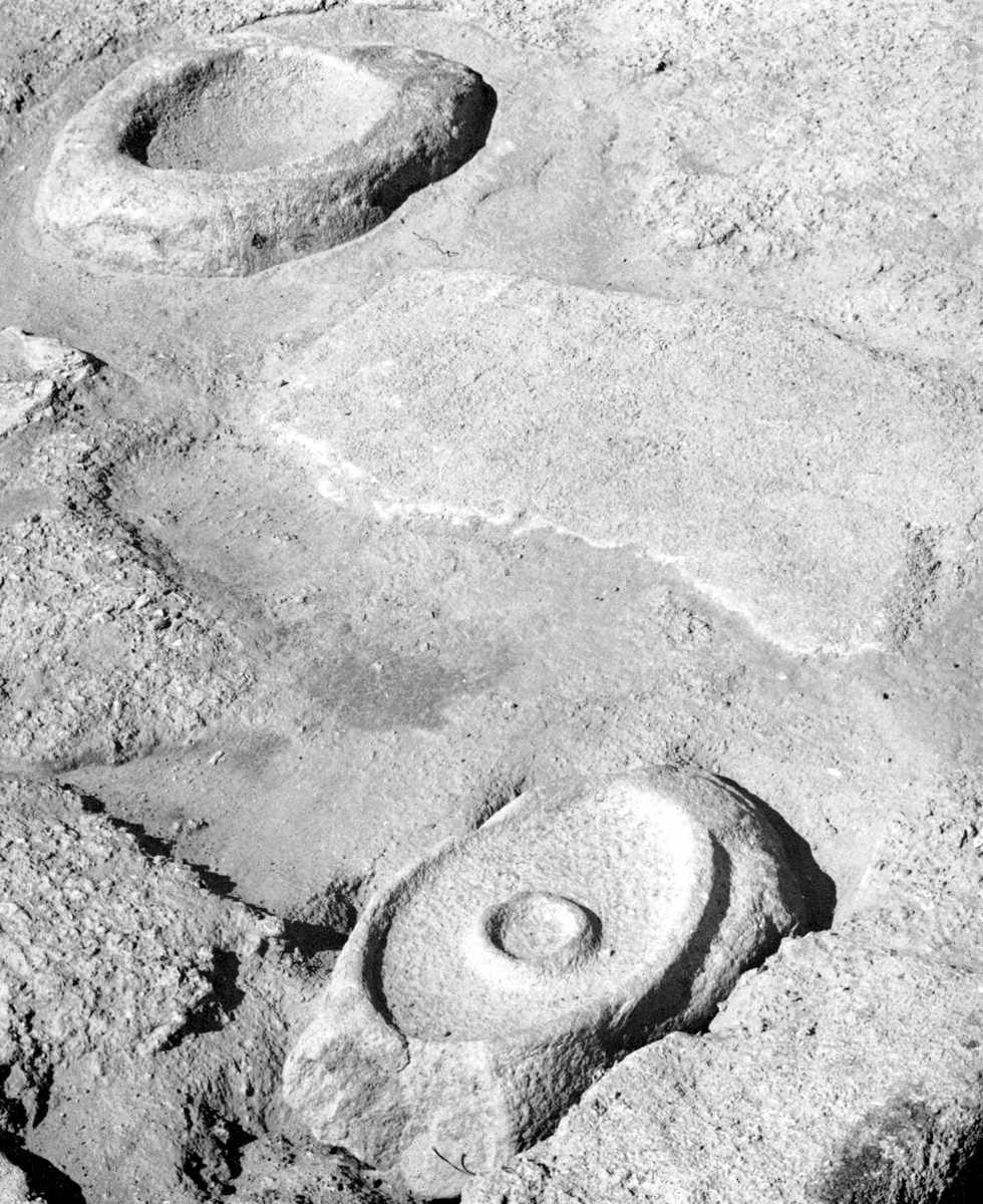
Lepenski Vir Ic - the hearth in house No. 51. At the north east angle of the hearth is a boulder of red sandstone on which a vulva has been carved, shown in the close up photograph below.
Photo: "Lepenski Vir" by Dragoslav Srejović 1972
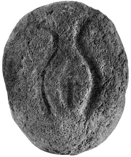
Sculpture from the hearth of house No. 51, Lepenski Vir Ic. It shows a vulva in a specific physiological state, just before giving birth, with all its anatomical details.
Photo: "Lepenski Vir" by Dragoslav Srejović 1972
Phase Ic is characterized by the fact that only either exceptionally large buildings or quite small ones were constructed in the course of it. Their outward appearance and internal space remain similar to those of the previous phase. The sanctuary built in house No. 37 follows in almost every detail the plan of the sanctuary of the central house from Phase lb.
It is significant, however, that before the end of phase Ic one more separate
sanctuary (No. 40) was erected to complement the 'sanctuary under the rocks'.
In this new sanctuary, with an area of 7 sq. m., were found two sculptures, one of which was lying in situ in the south-western corner of the rear wall. This sculpture called 'The Siren' was found, as may be seen in the photograph, above the head of a child buried beneath the floor. Two more detailed photographs of 'The Siren' are shown below.
Photo: "Lepenski Vir" by Dragoslav Srejović 1972
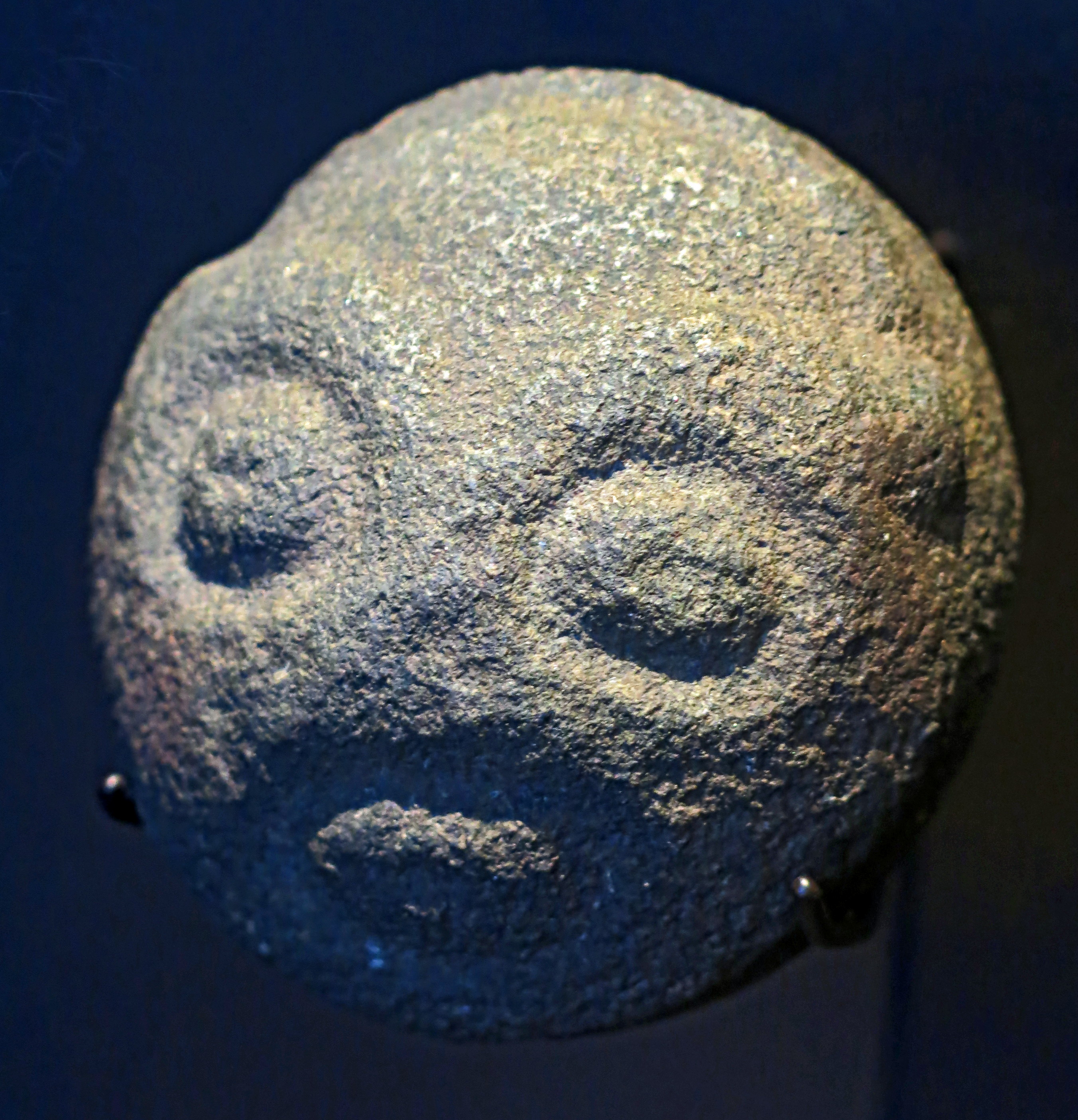
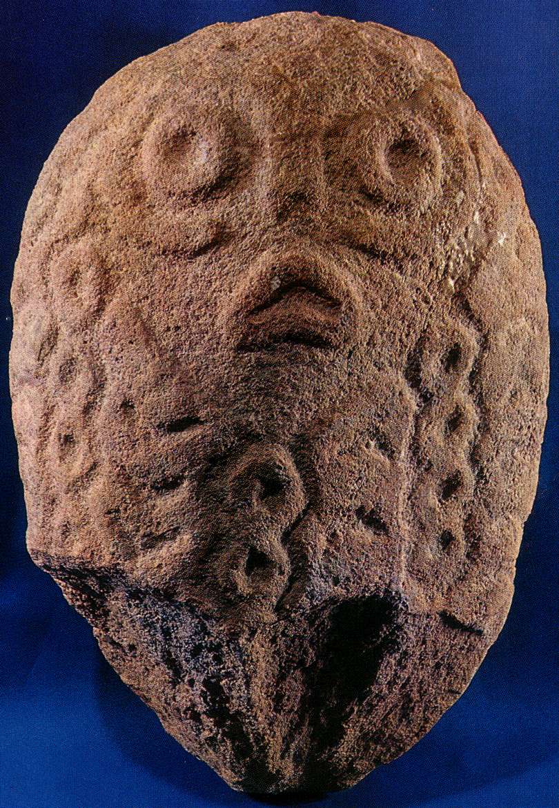
Small sculpture of a human head from Lepenski Vir, circa 8 000 BP.
Photo: Don Hitchcock 2015
Source and text: Original, Staatliche Museen zu Berlin, Neues Museum, Germany
Altar from the sanctuary in house No. 40 (Lepenski Vir Ic). Only the lower part of the altar, which was embedded in the floor, is decorated.
Photo: "Lepenski Vir" by Dragoslav Srejović 1972

'The Siren' from the sanctuary in house No. 40 (Lepenski Vir Ic), found above the head of a child buried beneath the floor.
The human face on this sculpture has curiously fish shaped features. (Lepenski Vir Ic)
(Note that the face has been sculpted on a naturally occurring boulder with an extended area to the back of the 'head' of the sculpture, adding to the fish-like impression. - Don)
Photo: "Lepenski Vir" by Dragoslav Srejović 1972
The other sculpture in building No. 40, which probably originally stood in the opposite corner of the rear wall, was set into the hearth itself. This means that the new sanctuary had a similar disposition to the 'sanctuary under the rocks' and differs from it only in one small but important detail: in the hearth construction a human lower jawbone was inset into the floor, with teeth downwards, and between its open ends a stone slab was placed vertically, giving the jawbone a form similar to a capital A.
This jawbone is the prototype of the mysterious 'triangles' which surround the hearth construction in the sanctuaries of the houses of Lepenski Vir Id -Ie.
Photo of jawbone with plaquette of stone forming the enigmatic letter A: "Lepenski Vir" by Dragoslav Srejović 1972
Sculpture No. 54 from building level Lepenski Vir Ic.
Photo: "Lepenski Vir" by Dragoslav Srejović 1972
The foundation of house No. 10 (Lepenski Vir Ic) which cuts through the foundation of house No. 11 (Lepensk Vir Id).
This is quite a small house compared to most others.
Photo: "Lepenski Vir" by Dragoslav Srejović 1972
This motif is repeated with stone slabs set alongside the hearths of houses Nos. 10 and 31, which were built before the end of phase Ic in the north-western part of the settlement. These buildings were also of small dimensions (6 sq. m. and 8 sq. m.) and one of them was unusually oriented, in a north-south direction. Since its rear wall is cut through by houses built at a later date (Nos. 11 and 33), it is not possible to confirm whether these two buildings were used exclusively as sanctuaries.
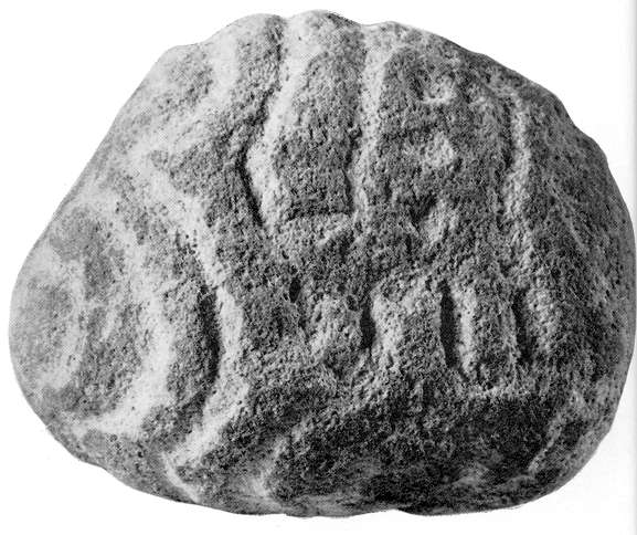
Human head of coarse grained yellow sandstone. This sculpture was found in the sanctuary of house No. 31 (Lepenski Vir Ic) with its face turned towards the entrance, the river and the rising sun. Its back has undulating furrows on the top of the head and the neck which form a complicated design recalling hairdressing or some textile covering the head.
Photo: "Lepenski Vir" by Dragoslav Srejović 1972
Hearth in the central large house No. 54 (Lepenski Vir Ib and Ic). Behind the hearth construction two stone sculptures, of which one is preserved in fragments, are embedded in the floor.
Photo: "Lepenski Vir" by Dragoslav Srejović 1972
The complete foundations of the central large house No. 54 (Lepenski Vir Ib and Ic) may be seen here behind the central large house of Lepenski Vir II (No. XLIV). It is not an accident that the two are placed in a similar location, in a commanding position over the rest of the settlement.
Photo: "Lepenski Vir" by Dragoslav Srejović 1972
Skeleton of a child found under the floor of the rear wall of house No. 40 (Lepenski Vir Ic)
Photo: "Lepenski Vir" by Dragoslav Srejović 1972
 House No. 49 (Lepenski Vir Ic). This miniature building has an unusual orientation (west - east) and is certainly the most enigmatic in the architecture of Lepenski Vir.
Two structures from phases Ic and Id (Nos. 55 and 49) merit special attention. They are two miniature houses, one of which was built in the north-western, and the other in the south-western, part of the settlement. Their foundations cover an area of only 1.4 and 1.9 sq. m. respectively, but otherwise they resemble the foundations of houses of normal size.
Photo: "Lepenski Vir" by Dragoslav Srejović 1972
No. 49 is built in front of the large building No. 27b and its frontage is turned towards it, that is to the west. No. 55 is built behind the large house No. 37 and is oriented in the customary manner: east-west. Both these miniature buildings are perfectly proportioned and may therefore have served as a model for all the other houses of settlement I.
Their function is a mystery. Nothing was found on the floors, but the stone flags from which the hearths were built have been charred by fire. Their construction foreshadows the division into types of individual buildings and suggests the beginning of a process which becomes pronounced only during the subsequent constructional phase.
Lepenski Vir Id
(adapted from "Lepenski Vir" by Dragoslav Srejović 1972)
Lepenski Vir Id showing the disposition of the houses and their plans and aspects. (The important houses No. 37 and No. 27a are shown in red. I have also added the position of the market place - Don)
Photo: "Lepenski Vir" by Dragoslav Srejović 1972
During Phase Id the unity of the settlement was finally destroyed. It was divided into two almost equal parts. House No. 37, now reconstructed, dominated the south eastern section, and the newly built house No. 27a dominated the north western sector.
The 'market place' was extended by about eight metres (? shouldn't that be "extended to about eight metres ?) at the expense of the central structure. (This appears to refer to the very large house No. 54 from Lepenski Vir Ic, which disappeared in Lepenski Vir Id. See the building plan for Lepenski Vir Ic on this page - Don)
Building activity was now intense. In the course of Phase Id about seventeen new houses were built, for the most part in the vicinity of House No. 27a and around house No. 37. (both shown in red on the map.)
Since these buildings were for the most part built on the upper terraces of the shelf, the houses on the river bank occupied a peripheral position. The sanctuaries on the north-western, or south-eastern, side of the settlement were no longer in use. House sanctuaries were numerous, but always designed according to a truncated and simplified plan. However a fresh element was introduced which in the preceding phase was only hinted at: the hearth construction in almost all the house sanctuaries was now accompanied by a frieze made up of a row of isosceles triangles with extended sides in the form of a capital A.
The sanctuary in house No. 19 (Lepenski Vir Id). The hearth is bordered by a frieze of 'triangles' and at the rear of the sanctuary, alongside the stone 'tables' a semi-aniconic stone sculpture of reddish sandstone is embedded in the floor.
Photo: "Lepenski Vir" by Dragoslav Srejović 1972
These 'triangles' are made of red stone slabs set vertically in the floor. The prototype of this new feature is the human jawbone with a stone flag alongside the hearth of sanctuary No. 40 mentioned above. This symbol had already been introduced in houses Nos. 10 and 31 but made exclusively from stone slabs; it became a common feature only in the house sanctuaries built during phase Id.
For comparison purposes, here is that prototype, repeated from further up this page, in italics:
The other sculpture in house No. 40, which probably originally stood in the opposite corner of the rear wall, was set into the hearth itself. This means that the new sanctuary had a similar disposition to the 'sanctuary under the rocks' and differs from it only in one small but important detail: in the hearth construction a human lower jawbone was inset into the floor, with teeth downwards, and between its open ends a stone slab was placed vertically, giving the jawbone a form similar to a capital A.
This jawbone is the prototype of the mysterious 'triangles' which surround the hearth construction in the sanctuaries of the houses of Lepenski Vir Id -Ie.
Photo of jawbone with plaquette of stone forming the enigmatic letter A: "Lepenski Vir" by Dragoslav Srejović 1972
The arrangement of these enigmatic signs gives the impression that they formed a border for triangular supports; in other words separate constructions may have been set up over the hearths. It is, however, characteristic that these 'triangles' are not always symmetrically arranged, that their number differs in each sanctuary, and that they are sometimes placed only along one side of the hearth. In the sanctuary of house No. 19 they form a continuous frieze (in all, fourteen 'triangles'), in houses Nos. 43 and 48 they are placed only along the longer, northern or southern, side of the hearth, and in houses Nos. 4, 12, 24, 27a, 32 and 47 they are arranged along both longer sides of the hearth, but in unequal numbers, in the ratio 4:7, 2:1, 4:5, 4:2, 6:1 and 4:3 respectively.
If these 'triangles' were not set up with any constructional intention they must have had a symbolic character associated with some sort of cult. It is significant that with the appearance of the frieze the stone 'tables' along the sides of the hearth disappear. In all the sanctuaries from phase Id the stone 'tables' (for the most part only two) are placed exclusively alongside the sculptures and stone receptacles, behind the narrower side of the hearth construction.
Since the frieze of red triangles is always firmly embedded along the longer side of the hearth, it is clear that during phase Id the living-space was extended at the expense of the sacral area. This new, restricted sanctuary scheme was rigorously adhered to in all buildings, but not always in every detail. In some buildings (for example houses Nos. 17 and 22) the frieze bordering the longer side of the hearth is omitted as is also the stone receptacle which was previously placed regularly in the centre of the sanctuary. Phase Id, in fact, is characterized by a lack of uniformity.
Hearth in house No. 24 (Lepenski Vir Id). The long sides of the hearth are bordered by a frieze of equilateral triangles made of small reddish stone slabs embedded vertically in the floor. The prototype of these 'triangles' is a human jawbone seen near the hearth of sanctuary No. 40. At one end of the hearth there is an altar with a shallow, rounded depression.
Photo: "Lepenski Vir" by Dragoslav Srejović 1972
Lepenski Vir I - the south western part of the settlement, seen from the Danube bank.
Photo: "Lepenski Vir" by Dragoslav Srejović 1972
'The Lady of Lepenski Vir'. This sculpture could not be classified, but on the evidence of style it may be concluded that it belonged to building level Lepenski Vir Id.
Photo: "Lepenski Vir" by Dragoslav Srejović 1972
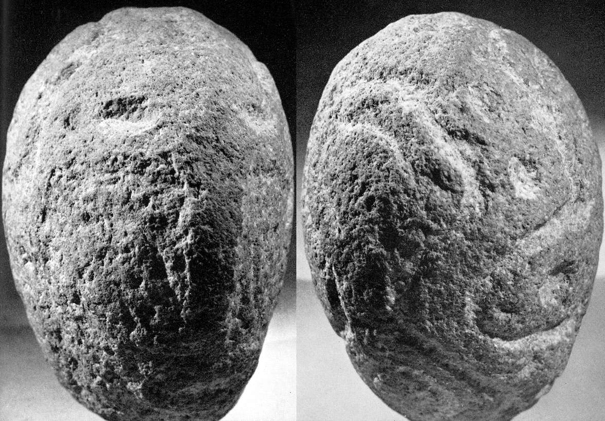
Sculpture No. 2. This 'medallion' probably belonged to the building level of Lepenski Vir Id or Ie
Photo: "Lepenski Vir" by Dragoslav Srejović 1972
House No. 24. Typical architecture of Lepenski Vir Id and Ie.
Photo: "Lepenski Vir" by Dragoslav Srejović 1972
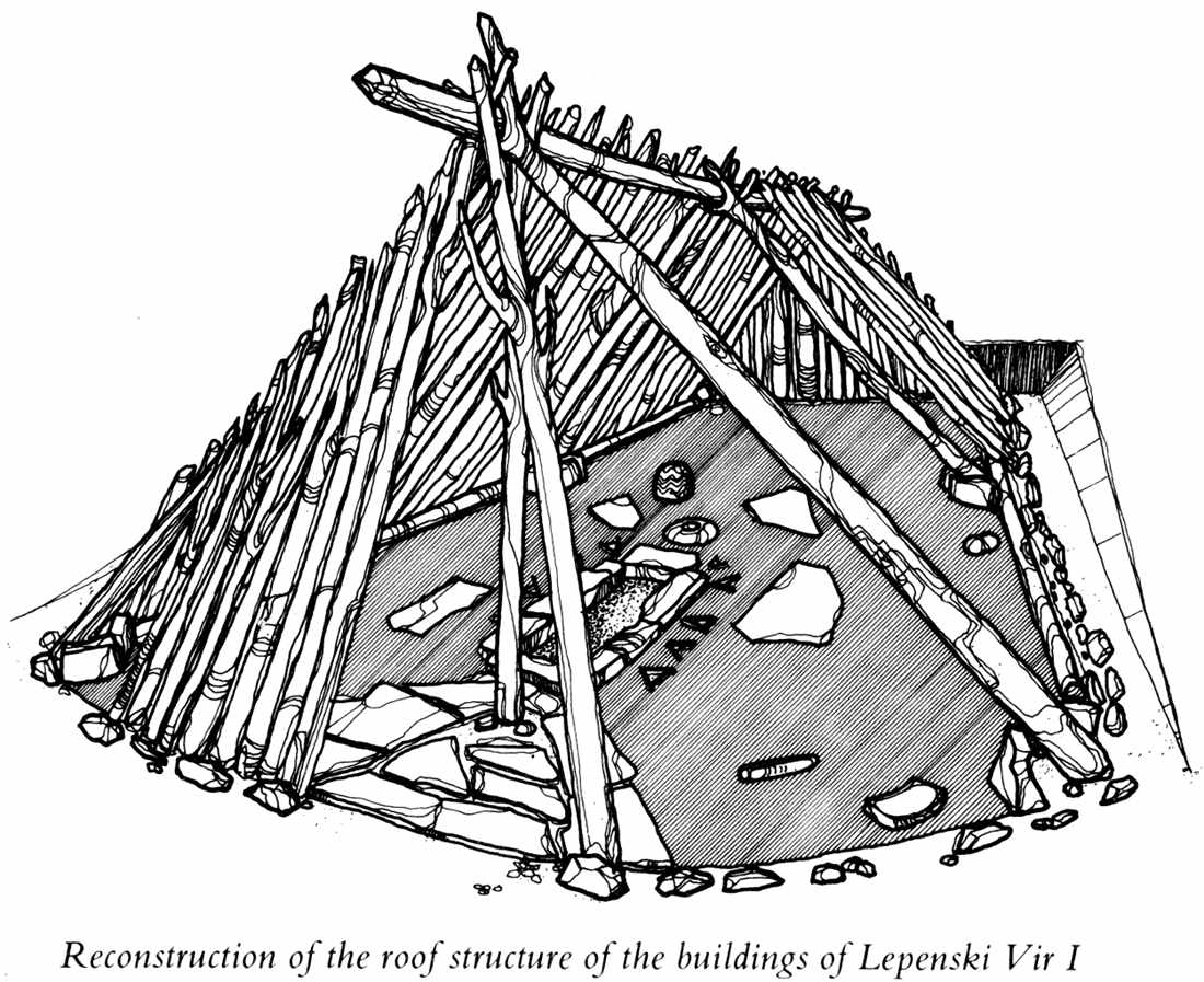
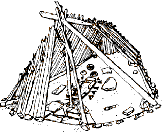
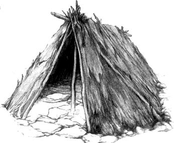
Reconstruction of the roof structure of the buildings of Lepenski Vir I.
Photo: "Lepenski Vir" by Dragoslav Srejović 1972
Lepenski Vir Ie
(adapted from "Lepenski Vir" by Dragoslav Srejović 1972)
Lepenski Vir Ie showing the disposition of the houses and their plans and aspects.
Photo: "Lepenski Vir" by Dragoslav Srejović 1972
The last constructional phase, Ie, reveals an intention to organize the settlement according to the old, original scheme and to re-establish its former building discipline.
This begins symbolically with the construction of a new central house (No. 57) larger than any yet built (frontage 9 m. with a foundation area of 36 sq. m.). Like the original central house (No. 54) this too was sited accurately along the axis of the shelf but was built on the highest, most prominent terrace. Because of the difference in terrace levels (2.18 m.) the 'market-place' did not extend to its frontage, the last terrace of the shelf being formed like a high platform which isolated the central house from the 'market-place' and the other buildings in the settlement. The 'main streets' therefore became steeper and were linked by a curving ramp whose sole aim was to make access possible to the central house.
The establishment of these new means of communication still further stressed the exceptional significance of the central building. Houses Nos. 37 and 27a, which in the preceding phase dominated the southeastern and north-eastern parts of the settlement, were no longer used. On the site of house No. 27a a new building of modest proportions (No. 27) was erected and house No. 37 was not rebuilt after demolition. All the other buildings were of average or small size and all centred on the new central building. The settlement again became homogeneous, but it is noticeable that there is no real internal compactness in the newly-established ordering.
During phase Ie the settlement was curtailed on the south and north sides and drew back from the river-bank, extending only in depth towards the high terrace on the western part of the shelf The boundaries of the settlement on this side are uncertain (the area which extended southward from the central house has not yet been excavated).
The basic communications ran radially, but because of the irregularity of the houses they widened out and became dispersed. All the houses, even the central one, are badly constructed; the floor of the central house is exceptionally thin and uneven and the sills at the entrance are very narrow and built up on thin slabs. Sculptures and stone receptacles are frequently lacking in the sanctuaries and along the longer sides of the hearths. In the place formerly occupied by the frieze a row of triangular holes is sunk into the floor.
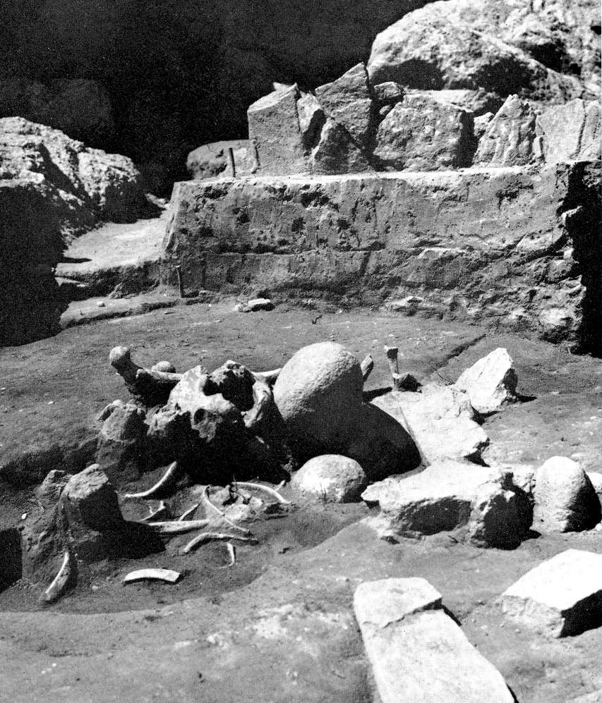
Grave No. 7, dug behind the hearth of house No. 21 (Lepenski Vir Ie). The skull of an ox rests against the skeleton's right shoulder.
(It is fascinating to speculate on the reasons behind this juxtaposition. Was the man killed by the aurochs? Or was he a renowned hunter? Was the aurochs his totem? - Don)
Photo: "Lepenski Vir" by Dragoslav Srejović 1972
Fragment of a sculpture placed at the head of the corpse buried in Grave No. 7, Lepenski Vir Ie.
Photo: "Lepenski Vir" by Dragoslav Srejović 1972
Owing to lack of precision in the proportions of the buildings, most of the foundations have an irregular, squat form. The back walls of the houses are too contracted and the arc of the frontage, not precisely marked out, frequently becomes a straight line. The internal areas are not clearly differentiated; the sanctuaries are often associated only with the hearth construction and the stone receptacle. In spite of this, in their axial symmetry the foundations of all the buildings erected in the course of phase Ie most nearly recall those of the houses of phase Ia.
These details show that during the last rebuilding of settlement I strict economy was exercised in respect of both materials and time. Despite this haste, however, the programme was not fully carried out.
The newly built houses were situated mainly on the north-western part of the shelf, and south-east of the central 'market-place' only one new building was erected. The south-east sector of the settlement, which remained empty and unplanned, shows that the rebuilding was not fully completed. Phase Ie was in fact of short duration, some event, which must have been of exceptional importance, temporarily halting the normal course of life. This local 'revolution' in fact serves as an introduction to the last stage of the culture of Lepenski Vir, during which a new settlement, Lepenski Vir II, was built.
Note the "A" symbols/supports around houses 19 and 24. It is not clear what these are or represent.
Note the "A" symbols/supports around house 19. It is not clear what these are or represent.
Lepenski Vir II
(adapted from "Lepenski Vir" by Dragoslav Srejović 1972)
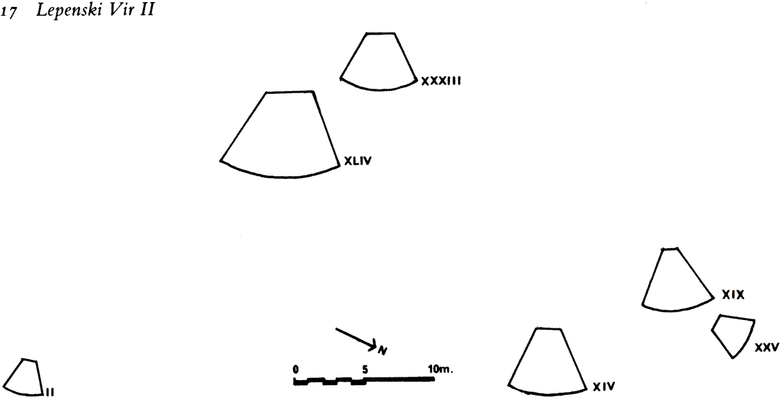
Lepenski Vir II showing the disposition of the houses and their plans and aspects.
(It might be thought that Lepenski Vir II had very few buildings from this plan of settlement. In fact the remains of forty-four constructions (I-XLIV) were identified. What is shown here is the disposition of only those houses whose foundations were sufficiently complete to be able to delineate them with certainty.
The other foundations were more or less completely destroyed by the building of Lepenski Vir IIIa. Only six complete house foundations (Nos. II, XIV, XIX, XXV, XXXIII and XLIV) have been preserved. - Don)
Photo: "Lepenski Vir" by Dragoslav Srejović 1972
The architecture of the subsequent period, Lepenski II, though a derivation of that of Lepenski Vir I, had its own individual style. The new settlement was built according to a programme which had already been envisaged at the beginning of phase Ie. However, since all the houses of settlement I were demolished, building began once more from the beginning, starting with the erection of a central house on the highest terrace of the shelf, and was then carried on consecutively despite the changed configuration of the terrain and insufficient knowledge of the old constructional procedures.
The general appearance of the shelf had been completely changed by the earlier intensive building activities: step-terraces had been formed on its originally sloping surface and large level areas created.
(This demonstrates that the people of Lepenski Vir II had donated time and effort for the public good in creating these large level areas - Don)
The houses of settlement II were not, therefore, built on firm natural foundations but on an unstable and artificial base. This both simplified and at the same time complicated house construction. In order to find room for the backs of the houses it was no longer necessary to cut into the slopes of the shelf but for that very reason more time and labour had to be expended in making them secure.
A detail of part of the paving of the "main street" of the settlement in Lepenski Vir II.
(This is another indication that the inhabitants of Lepenski Vir had organised themselves, or had been organised by their leaders to work on public infrastructure - Don)
Photo: "Lepenski Vir" by Dragoslav Srejović 1972

Front of the sanctuary of house No. XLIV (Lepenski Vir II) with sculptures of Danubius and another iconic sculpture (shown below) in situ.
Photo: "Lepenski Vir" by Dragoslav Srejović 1972
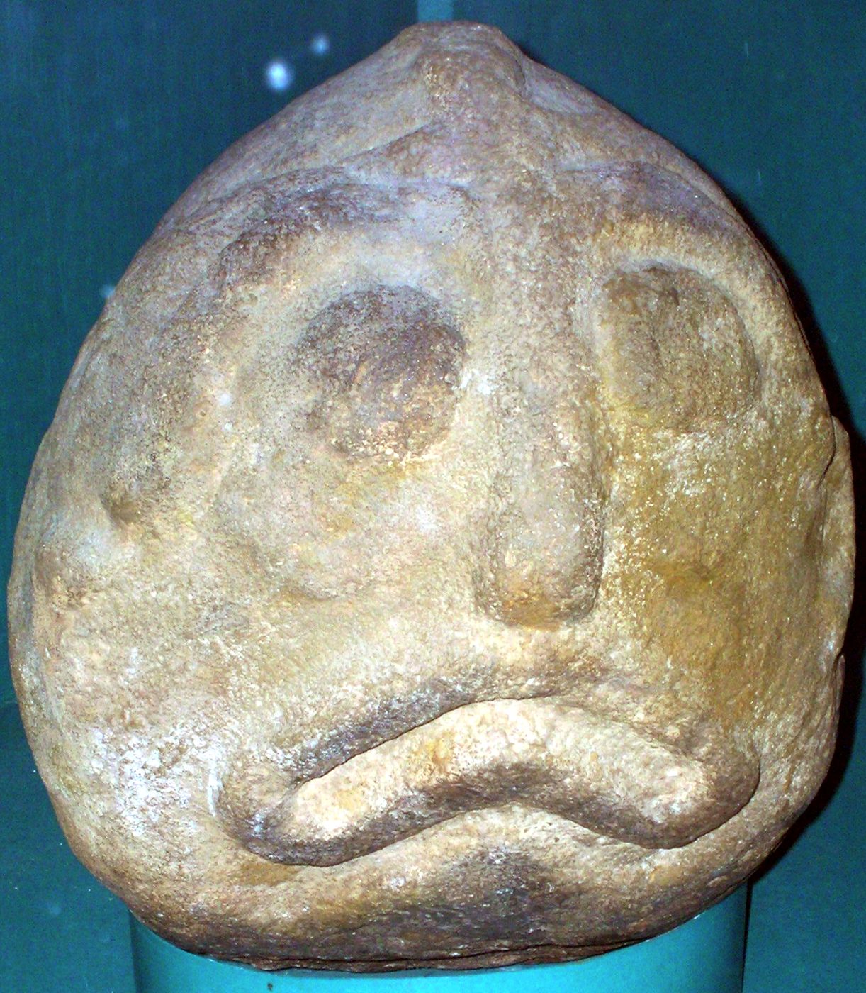
Rear of the sanctuary of house No. XLIV (Lepenski Vir II) with an aniconic boulder (i.e. it is a simple boulder, not a sculpture - Don) and a sculpture embedded in the floor alongside the large stone 'table'.
(I cannot help but note that this particular sculpture looks like a caricature of someone who is suffering a monumental (!) hangover from a big night out on alcohol. The bags under the eyes, the sad expression, the lopsided grimace, all contribute to the illusion.
Note also that it is possible that because of regular flooding of the site many of the sculptures and other artefacts may have been embedded in the mortar used to floor the houses to avoid them being washed away - Don)
Photo: "Lepenski Vir" by Dragoslav Srejović 1972
Sculpture from the front of the sanctuary in house No. XLIV (Lepenski Vir II).
Photo: "Lepenski Vir" by Dragoslav Srejović 1972
'Danubius'. Sculpture from the front of the sanctuary in house No. XLIV (Lepenski Vir II).
Photo: "Lepenski Vir" by Dragoslav Srejović 1972
Sculpture No. 43 was found along the south-east side of the central house (No. XLIV?), but probably originally stood in the south-western corner of its sanctuary, whence it was moved because of the later digging of a grave.
(It seems to me that the base of this sculpture has either been carved into a pointed shape, or the sandstone has been eroded perhaps by acidic conditions in the ground in which it was embedded. - Don)
Photo: "Lepenski Vir" by Dragoslav Srejović 1972
Hearth and altar in House No. XXXIII (Lepenski Vir II). In this building was buried a man whose skeleton was damaged during the building of Lepenski Vir IIIa.
Photo: "Lepenski Vir" by Dragoslav Srejović 1972
In the erection of larger buildings, especially those like the central house, the terraces had to be underpinned with great stone blocks to prevent the unstable foundations from slipping or the house frontages from subsiding. This work, which must have been organized collectively, besides demanding enormous effort also presupposes a certain technical knowledge, for the great stone blocks which support the highest terrace in the western part of the settlement weigh 100 kg or more each.
There was the constant danger too that landslides from the higher terraces might crush the backs of the houses. Directly behind them, therefore, arched supporting walls of stone blocks and slabs were set up to a height of about one metre. These constructions, executed in a dry-stone technique, are solidly built and in some layers have been preserved complete.
In the background is the drystone supporting wall of limestone slabs at the rear of house No. XXXIV (Lepenski Vir II) with the remains of a burial in the foreground.
Photo: "Lepenski Vir" by Dragoslav Srejović 1972
Lepenski Vir II has an area of about 2 400 sq. m. and includes the entire area of the ruins of settlement I. The boundaries of the older settlement were only overstepped on the north-western side where two large houses were built behind the tumbled rocks which had hitherto bordered the inhabited area. The shape of the shelf still formed a natural rampart for the settlement, and stone and wood from the steep slopes of the Koeso hills were employed as basic building materials. The architecture of the new settlement is only partially known. Though the remains of forty-four constructions (I-XLIV) have been revealed, the buildings of settlement II were for the most part destroyed during the construction of Lepenski Vir IIIa. Only six complete house foundations (Nos. II, XIV, XIX, XXV, XXXIII and XLIV) have been preserved, but judging from the abundance of stone blocks and slabs found over the entire area investigated it may be concluded that Settlement II consisted of at least thirty structures.
The houses of settlement II were mostly erected upon the demolished buildings of settlement I. Here the terrain had been levelled and the subsoil was more stable. All the foundations have a trapezoidal form the shape of a truncated segment of 6o°, but when compared with the foundations of the houses of Lepenski Vir I they are more carelessly constructed and cruder in their proportions. They no longer appear to be based on the primary isosceles triangle which determined all the buildings of settlement I. The trapezoidal shape of the foundation has been created without understanding, freely and 'by eye'.
This disharmony in proportion was probably due to changes in the configuration of the terrain. The houses of settlement II were erected exclusively on the levelled terraces and therefore the measurements of their foundations were to a great extent dependent on the area available for building.
(I find these last two sentences I have rendered in bold difficult to agree with. If the building surface was level and flat, it would surely have been easier to get the dimensions right than if the builders had been struggling with an uneven surface. It would appear to me that the rigorous attention to detail of the mathematical proportions of the houses was at this time found to be unimportant, for whatever reason. - Don)
Since the trapezoidal shape was well known, the contours of the foundations were marked out at once, as earlier, by a border of broken stone. The same order of construction was then applied as in the building of the houses of settlement 1, though the manner of construction varies in certain details. Thus the post holes for the roof beams are again at the edges of the foundation, but now the stone slabs which line and strengthen them are always placed horizontally, not vertically; the position and shape of the hearth remain the same and the stone receptacle is in its usual place; the hearth construction is however no longer in the ratio 1:3 but most frequently in the ratio 1:2 and the stone receptacles become wide and heavy.
The houses did not change their external form, but their interior looked different, they were no longer floored with limestone mortar. As the subsoil was not ideally level and there was no firm floor, the building construction in the interior of the house could not be made up, as earlier, of small and light stone slabs, but only of large and heavy stones which frequently had amorphous forms. The irregular shape of the stones gave the houses of settlement II uneven edges and inaccurate proportions. They were all heavy and clumsy, and, though they sometimes seem monumental, their appearance shows clearly that the sense of accurate proportion and the careful execution of detail had been lost.
The hearths were shortened mainly because of the instability of the sub-soil and for the same reason only large and heavy boulders were chosen for the receptacles and the sculptures. Whereas in the sanctuaries of settlement I the 'triangles' placed along the longer sides of the hearth seemed like a fine mosaic of thin and delicate red slabs, in the sanctuaries of settlement II they were formed roughly, always from relatively large and wide limestone slabs.
The interior of the houses of settlement II followed the traditional model, except for the sanctuary of the central house No. XLIV. This was overburdened with details which were previously mutually exclusive, having both the stone 'tables' typical of houses built during phase Ib and the 'triangles' hitherto associated only with household sanctuaries from phases Id and Ie. The centre is not, as earlier, marked by the stone receptacle but by a large amorphous boulder with an enigmatic design in the form of the letter V, and the frontage and the rear wall of the sacral area are characterized by monumental sculptures.
In the rear wall there was only one sculpture in the usual place outside the axis of the hearth, but, surprisingly, three large sculptures were placed in the frontage, two directly along the narrower side of the hearth and the third between the sloping threshold and the adjacent stone 'table'. These three sculptures completely fence in the sacral area on the eastern side which, in earlier sanctuaries, was always free and wide open towards the entrance. This new disposition of the sculptures changes the conception of the sanctuary and, indeed, the whole atmosphere of the sacral area. This confused internal structure makes the central focus of the house less evident and destroys the former balance between the sacral area and the living-space.
Judging from the plan of the sanctuary, its proportions and situation of the hearth, it may be concluded that house No. XLIV is the oldest building of settlement II. It lies directly on the axis of house No. 57 which dominated the settlement in phase Ie and differs from it only in its dimensions and the construction of the floor. The hearth of the older building had been demolished and its floor destroyed, but the stone 'tables' were left in place and included within the sanctuary of the newly-built house.
In order to fill up the free interspace the hearth was built in the form of a lengthened rectangle; in other words its dimensions were not determined by the measurements of the new building but by the size of the former sacral area. In all the other houses where the constructional principles applied to the older style of architecture were ignored, the width of the hearth is approximately twice its length and in some cases (houses Nos. X and XXV) is almost square. If one compares the rectangular hearths from houses Nos. XIX and XLIV with the approximately square hearths in houses Nos. XIV and XXV, it may be concluded that the classical proportions gradually changed and that settlement II widened out by degrees from the raised back of the shelf towards the river.
(It appears to me that Lepenski Vir I was the pinnacle of what might be thought of as the ascetic, architectural phase of the habitation of the site. The houses were the important part of the life of the community.
It was in the houses, their method of construction and their arrangement on the site that the inhabitants made a statement of their view of their environment.
The rigorous use of the trapezoidal outline of each of the houses, the adherence to high standards of construction and to the consistency between the houses was an outward sign of their adherence to a conformity of purpose. They poured their energies and their artistic life into their dwellings.
Certainly, there were the beginnings of the use of sculpture within the houses. Some boulders were carved with various designs, and there was at least one representation of a human face. It has artistic merit, but is certainly not a complex design.
It was in the Lepenski Vir II phase that the emphasis shifted to displaying their view of the world they inhabited from architecture to sculpture, and the sculpture became more sophisticated and complex. It is in the Lepenski Vir II phase that we find some of the inhabitants spending a great deal of their time and effort to creating sculptures from the sandstone they found in the vicinity. We can only guess at the wooden sculptures that may have been lost because of not being preserved.
These sculptures are so well made and of such high artistic merit that it would appear there had developed a class of artists who were able to devote most of their time to the creation of these masterpieces.
This further implies that the inhabitants were "wealthy" in terms of their access to food, clothing, houses and the means of creating and maintaining them.
Only if the community was wealthy in this sense could a group of artists have the time and energy to devote themselves to the creation of such well executed and artistic creations which were all part of the same tradition.
Further, it would appear that fish played an important part of the religious life of the people of Lepenski Vir in this second phase.
Nearly all the sculptures are either of fish, or are of humans with fish like characteristics. This speaks of the importance of fish in the economic life of the people.
Lepenski Vir is ideally suited for the harvesting of fish. The legendary sturgeon would have provided a huge amount of food for those with the ability to catch and land it.
As well, there were many smaller species of fish in the Danube which would have provided normal fare and the provision of precious protein, with minimal skills needed to land them, either by line, net or trap. - Don)
Graves Nos 8 and 9 from Lepenski Vir IIIa which lies 0.5 m. below the floor of house No. 24 from Lepenski Vir Id.
Photo: "Lepenski Vir" by Dragoslav Srejović 1972
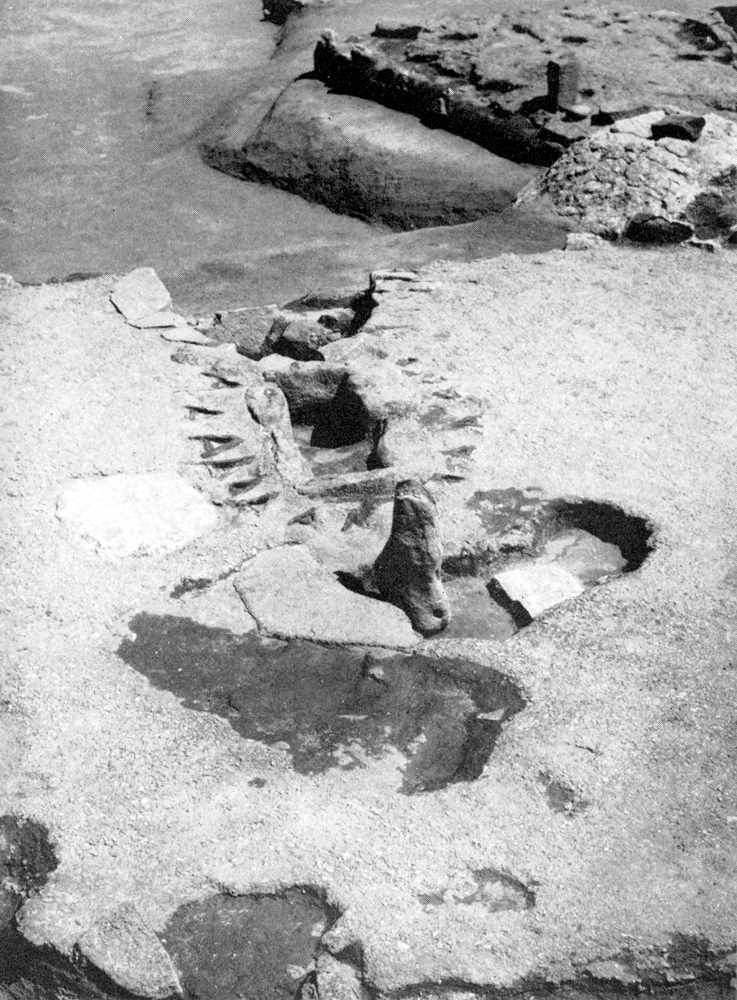
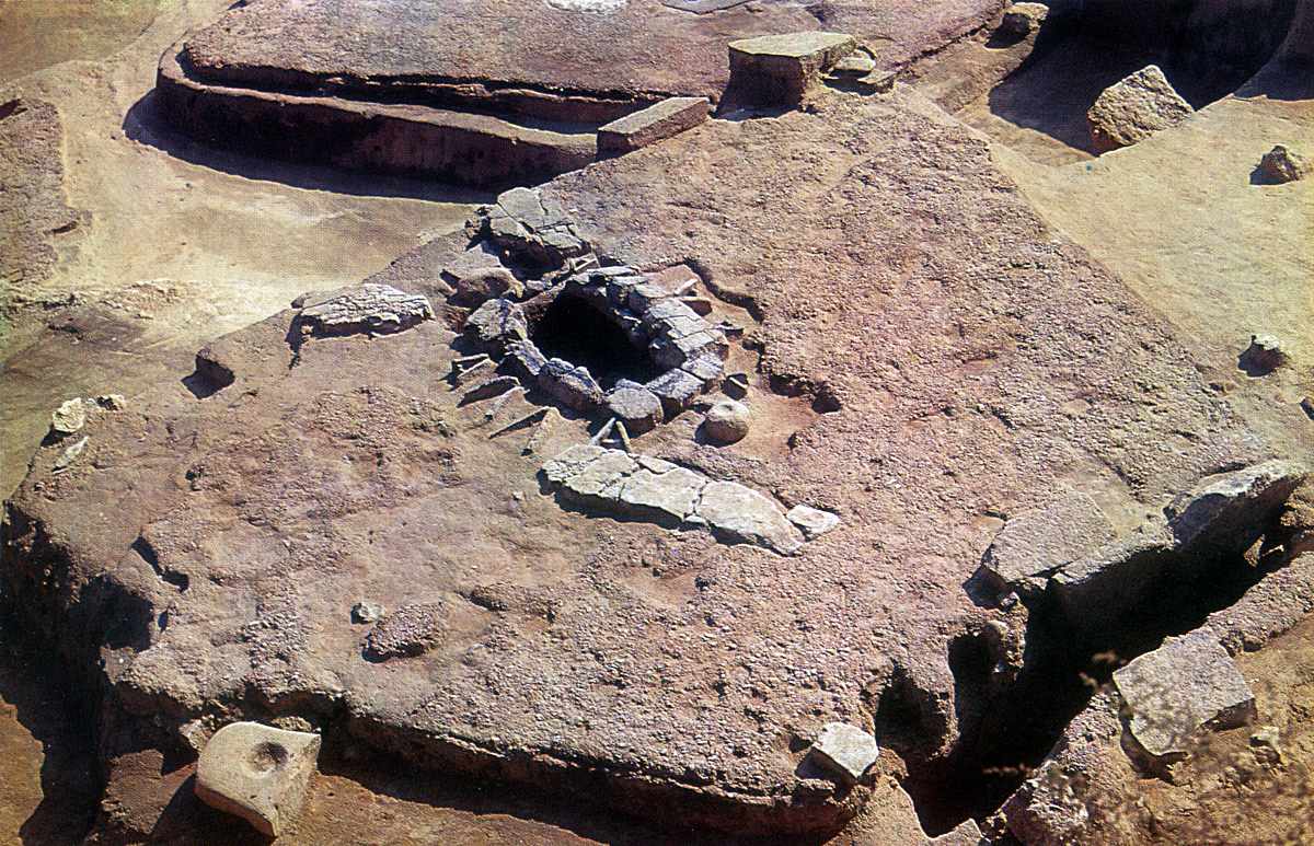
Horseshoe shaped oven discovered in the central hut of Lepenski Vir IIIb. Behind it can be seen the central house of Lepenski Vir II (No. XLIV) and in the background the central house of Lepenski Vir Ib (No. 54)
Photo: "Lepenski Vir" by Dragoslav Srejović 1972
Raw material and manufacture
The altars and sculptures of Lepenski Vir I and II were manufactured of quartzitic sandstone with silica impregnation. This raw material came from a single geological formation, red Permian sandstones which were not far away in the hinterland. These sandstones were eroded and are found as boulders in conglomerates at Somrdo Hill. They were further eroded by the Somrdo stream, then moved by water current to the Strakovica, and then further to the Boljetinska River (about two kilometres from Lepenski Vir). They are also found in the Pesaca stream (about five kilometres away). The colour of the boulders varies: yellowish-white, almost white, reddish. Some boulders wear traces of secondary (hydrothermal) pigment that can be distinguished from the traces of burning. The boulders were manufactured by hammering the surface around the preconceived ornamental and figural motifs. Additional coloring of boulders by red pigment also appears.
Text: The Iron Gates Mesolithic, I. Radovanović
Photo: http://kravcev9.tripod.com/arch1/id2.html
To see more photographs of Lepenski Vir, go to
 Lepenski Vir
 It's in Serbian, but the photographs are very interesting.
From the web site given above: http://www.yurope.com/people/nena/Vir/arhitekt.html
Lepenski Vir
Image of terrace:
The Serbian text that goes with this is:
Ovaj sklad izmedju ambijenta i arhitektonskih formi postignut je, medjutim, pomocu mera i proporcija koje se ne nalaze nigde u prirodi. Arhitektura Lepenskog Vira ima u sebi neceg izrazito matematickog, odnosno u svim njenim formama oseca se prisustvo konkretnih duzi i odredjenih brojeva. Oseca se jasno da su arhitekstonske forme prozete mistikom brojeva, ali osnovnu jedinicu mere nije moguce prevesti na jezik nase matematike; to nije nijedan odredjeni broj ni neka antropoloska mera i mada je modul sigurno dobijen racionalnim postupkom, on ipak deluje kao misticna velicina kojom su izgradjeni mikrokosmos i makrokosmos kulture Lepenskog Vira.
Which has been kindly translated for me by another Auel fan, Ivana from Belgrade:
This harmony between the environment and architectural forms has, on the other hand, been achieved with measurements and proportions which cannot be found anywhere in nature. The architecture of Lepenski Vir has something extremely mathematical in it; that is, in all its forms you can feel the presence of concrete lines and specific numbers. It can clearly be felt that the architectural forms are saturated with the mysticism of numbers, but the primary unit measure cannot be translated into today's mathematical language; it is not one specific number or an anthropological measurement and, although the module has been made through rational procedures, it still seems like a mystical dimension that has built the microcosms and macrocosms of Lepenski Vir.
Per turned up this image of the area, (again from the site with link above) with the castle the white object near the middle of the photo, across the water:
From the site:http://www.yurope.com/people/nena/Vir/zastita.html
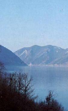
Note that this shot is looking upstream from below Lepenski Vir, which is out of sight to the left of this photograph, between the camera and the dark ridge in the left background which drops steeply to the water.
The Serbian text that goes with this has again been kindly translated for me by Ivana from Belgrade:
The architectural remains of Lepenski Vir were transferred to new locations in two ways. A certain number of characteristic and representative objects were transferred whole and intact, or else their central parts with the hearth and surrounding equipment were transferred along with a 75 cm to 100 cm thick ground foundation. Objects which were transferred whole weighed about 20 tons with their ground foundations. They were dragged to their new location by a ramp, (a slope or incline) which made the transport of the artifacts easier because they were slid to their new location up the slope, cut through between the original and new locations. The second method consisted of digging out fragments of the floor of suitable size and all parts of the house construction, which were then reconstructed in the new locations. This method was used for most of the objects, since it was known that beneath the floors of the houses which were to be dislocated, existed even older remains which should be archaeologically examined
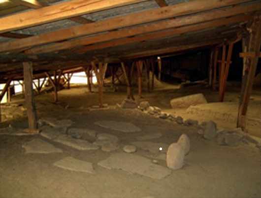 Photo of the moved site of Lepenski Vir: IRPPSAAH_PIL-SERBIA.pdf published by European Commission - Council of Europe Joint Programme: Integrated Rehabilitation Project Plan / Survey of the
Architectural and Archaeological Heritage (IRPP/SAAH) - Serbia and Montenegro (Serbia) - March 2004
Photo of the moved site of Lepenski Vir: IRPPSAAH_PIL-SERBIA.pdf published by European Commission - Council of Europe Joint Programme: Integrated Rehabilitation Project Plan / Survey of the
Architectural and Archaeological Heritage (IRPP/SAAH) - Serbia and Montenegro (Serbia) - March 2004
The original site is now under water, although some of the main features and all of the sculptures from the site have been moved to higher ground.
The sad plight of the rescue mission
This text is adapted from:
PTA_Serbia(SerbiaandMontenegro)_LepenskiVirMuseum_APP.pdf
With the title:
Integrated Rehabilitation Project Plan/Survey of the Architectural and Archaeological Heritage (IRRP/SAAH)
Document adopted by the Ministry of Culture and Media of the Republic of Serbia and the Ministry of Foreign Affairs of Serbia and Montenegro on 27th January 2006.
 The site and the museum are in a bad condition. The temporary protective roof structure
does not diminish the danger of decay to the site which continues to be high, requiring
emergency interventions. Risk of decay is high, and emergency interventions are
necessary. In spite of its bad condition, the Museum of Lepenski Vir, which is
open only six months a year, has between 10 000 and 20 000 visitors.
The site and the museum are in a bad condition. The temporary protective roof structure
does not diminish the danger of decay to the site which continues to be high, requiring
emergency interventions. Risk of decay is high, and emergency interventions are
necessary. In spite of its bad condition, the Museum of Lepenski Vir, which is
open only six months a year, has between 10 000 and 20 000 visitors.
It has a very convenient geographic position, good road and waterway, accommodation
facilities, river and marina in Donji Milanovac (a small town only 12 km distance from the site),
and offers an excellent opportunity for tourism.
Executive Summary:
The site and its management
Lepenski Vir is an archaeological site of outstanding international importance. The site is situated on the right Danube shore, in Djerdap (Iron Gate) gorge, on the Serbian/Romanian border.Nowadays, the site is located in a natural reserve and in an exceptionally picturesque landscape. During archaeological excavations in 1960's seven successively built prehistoric settlements were discovered. These settlements contain remains of 67 apparently planned dwellings, fireplaces, tools, instruments, as well as jewellery. The settlements also contain altars and sculptures, carved from round sandstone cobbles which are of particular artistic, aesthetic, as well as ritual and symbolic significance.
Lepenski Vir is an area where an exceptional culture and specific art was born and lasted within organized social and religious life, which was unique in Middle and South-Eastern Europe (6800-5400 BC, according to C14 dating). The methods and complexity of the architecture of the buildings, and the treatment of the associated monumental sculpture clearly define phases of the settlement over the period of a thousand years. This discovery of a Neolithic/Mesolithic settlement was of international scientific importance.
Due to its exceptional scientific and cultural importance, as well as unique historical remains of the past and its special position in the Danube gorge, Lepenski Vir is an important landmark on tourist and academic routes. It contains the potential to become one of the most attractive points for Danube cruises, as well as having large potential economic significance in the local community. Total protection is hindered by the complexity of the Lepenski Vir site and its place in natural reserve, as well as the lack of well defined financial resources for some necessary works. A feasibility study is necessary for the creation of a precisely planned long term sustainable project.
Statutory Protection/Constraints Lepenski Vir site was listed on May 26, 1966 as a monument of culture by the act of Institute for the Protection of Cultural Monuments of Serbia (act no. 554/1), borders of the site were defined with additional act on February 3, 1971 (act no. 10/21). It is categorized as a cultural monument of exceptional significance in 1979, under the number AN 45 (Official gazette, No. 14, April 7, 1979).
Part of the Djerdap natural reserve in Lepenski Vir area is protected by the state by the act of Majdanpek municipality on November 3, 1970 (act No. 03-1770). All activities have to be conducted in accordance with the Law on Protection of Cultural Properties of the Republic of Serbia (1994), as well as with the Law on Planning an Building (2003). Measures and conditions of preservation, protection and development of the National Park area are defined on August 19, 1979 (Official gazette SRS No. 34, page 12/79).
Summary of Physical Condition - very bad to good.
After completion of archaeological researches, due to the danger from flooding by the artificial lake from the Djerdap power plant, the Lepenski Vir site was moved to higher ground. In the early 1970's archaeological remains (houses) were conserved and protected with a temporary roof structure. A museum was built near the site, where a part of the moveable archaeological material is also displayed.
The assessment of the important parts of this site is:
Temporary protective roof structure - very bad.
Archaeological remains - bad.
Museum - bad.
Risk of decay is high.
There is a high priority for intervention, with necessary high investment in the site.
Documentary sources:
A vast documentation of archaeological research (field research diary, basic sketches, outlook sketches, photos) is gathered and is in the Archaeological Institute in Belgrade.Projects for the relocation of the site and field architectural documentation on entities and transport is in the Institute for the Protection of Cultural Monuments of Serbia.
Documentation on moveable cultural Properties, at present the Lepenski Vir Collection, is stored in the National Museum in Belgrade.
Documentation of archaeological researches was made according to regulations and conditions of the 1960's. Today, it is a satisfactory data source.
Documentation is available and it is at the disposal of experts.
(Note, "experts" in this part of the world ( Serbia and Romania in particular) is a catch-all term for researchers, professors, and similar people well qualified to make decisions about the worth and disposal of archaeological discoveries. The term is subtly different to the normal english meaning of the world, where an expert may well be someone without formal qualifications. Here, an expert is a term for someone who is part of the academic hierarchy, with impeccable credentials. - Don)
Financial estimates already made:
Financial estimates for building protective structures and for the effective presentation of the Lepenski Vir site are made according to the Draft protection project, which is currently under evaluation.
Architectural and building works €700 000
Protective structure €400 000
Heating installations €300 000
Electrical and other installations €500 000
Conservation and museum exhibition €50 000
Total estimate €1 950 000
Lack of funding for maintenance and investments
Since the beginning of 1980's site funds for the maintenance and repairs of the temporary roof structure have been minimal.
Many deficiencies of the roof of the Lepenski Vir site have shown up after 20 years of use.
Since the mid 1990's, the Museum building is also in a bad condition.
There is a lack of investments funds, lack of stable power systems and stable climatic conditions. (The site is not protected from the very bad winter conditions of the area - Don)
Since the end of 1980's, the Museum and the site were getting their electricity supply from power generators. The present system is not suited for any heating system that would stabilise conditions at the site. (It is subject to wild temperature fluctuations between summer and winter. The only protection is a very temporary roof with no walls. - Don)
Therefore, it is subject to climatic factors and the volatilities of changing humidities and long and hard winters. Those conditions significantly contribute to the deterioration of the site.
Lack of road infrastructure
Access to the site was very difficult until the beginning of the 1990s when a new road was built to the site.
However, the harsh climate makes this road very dangerous during winter time. Access to the site is difficult from November till February.
Tourism
Lepenski Vir does not have adequate prerequisites for visitors.Technical condition
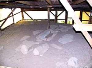
The site containing remnants of the preserved houses/shrines are on artificial step-shaped terraces of the
Danube slope, covered with a wooden roof, which is supported by wooden pillars, following
the steep slope. Structures are exposed to harsh climatic changes, which influence their
slow, but certain deterioration.
Special danger comes from water and humidity, which
washes the bases of the terraces and make wooden beams rot and deteriorate, which results in
occasional roof collapses.
Walk paths and smaller wooden platforms exist nowadays only on
the southern side of the site. It hinders its adequate presentation.
There is a lack of sufficient lighting.
Photo: http://solair.eunet.yu/~lepenski/
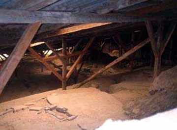
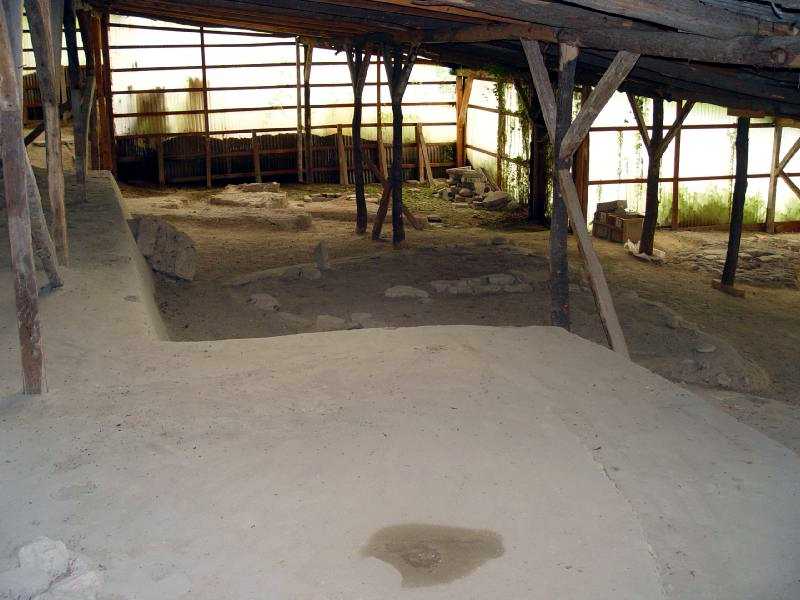 Recent photograph of the outside section of the Lepenski Vir recreation site.
Although the roof and its supports seem to be unchanged, being very low and made in a perfunctory and ad hoc fashion, with unpeeled logs used in places, and extra props added as they became necessary, the site seems to have been enclosed with clear plastic weatherproof building sheets.
Note also the seepage in the far corner where moss is growing on the floor and the evidence of a roof leak in the foreground shown by a small depression which is surrounded by moist ground.
- Don
Photo:
http://good-times.webshots.com/photo/1435697354042073617GuBevU
Museum
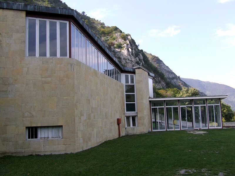
This building is made of brick, stone and glass, with no air conditioning, with
minimal firefighting equipment and security installations. The northern wall is resting on the
slope of the hill, so water and humidity damaged this side, jeopardizing electric
installations.
Poor thermal insulation causes very high temperature fluctuations. There are
no adequate conditions for visitor access.
Photo:
http://good-times.webshots.com/photo/1435697354042073617GuBevU
(Note that these are recent photos which appear to show a well constructed museum, so perhaps some of the problems detailed in this report have been rectified - Don)
Auxiliary buildings
These are typical houses of rural architecture of this region, made from bondruk (mud-bricks and wood) with smaller cellars, which are used by the museum for accommodation of its employees (the manager, guide, and guards). These houses satisfy only the minimum of living standards.
There is also a small parking area, and an inadequate pedestrian path from the parking area to the Museum and the site. Access for visitors with special needs and older people is very difficult.
Road infrastructure / access to the site
There is a sharp and difficult turn from the main road, insufficiently marked, dangerous in bad conditions such as in rain. Access in winter is almost impossible due to road icing and snow.Changes / conservation
A permanent solution for this site is necessary, and urgent.A management plan and a systematic analysis of the sustainability of Lepenski Vir are required.
Preliminary Technical Assessment carried out by:
Dr Tatjana Cvjeticanin
Belgrade, August 31st, 2005.
(My sincere congratulations to Dr Cveticanin. This is an excellent though chilling and depressing assessment - Don)
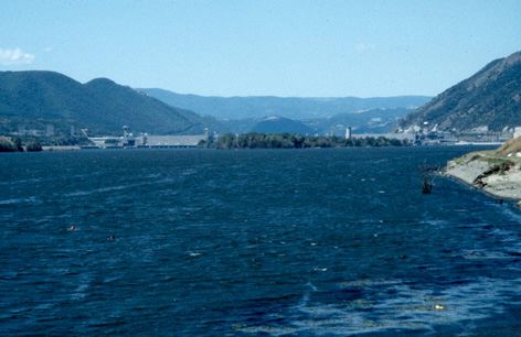
Photo of the dam at the Iron Gates
Photo: http://www1.arcl.ed.ac.uk/arch/clivebonsall/page7.htm
The site now appears to be well conserved at last.
Photo: Philipp Weigell, 24 April 2012
Permission: Creative Commons Attribution 3.0 Unported license
Some references:
D. Srejovic, Lepenski Vir, Belgrade, 1969.
D. Srejovic, Lj. Babovic, The Art of Lepenski Vir, Belgrade 1983, Mirjana Tomic
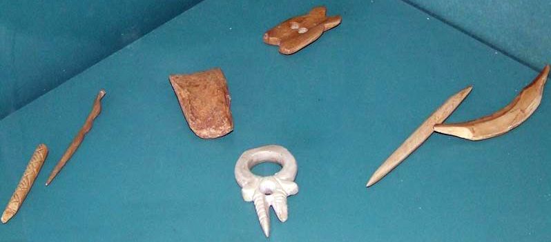
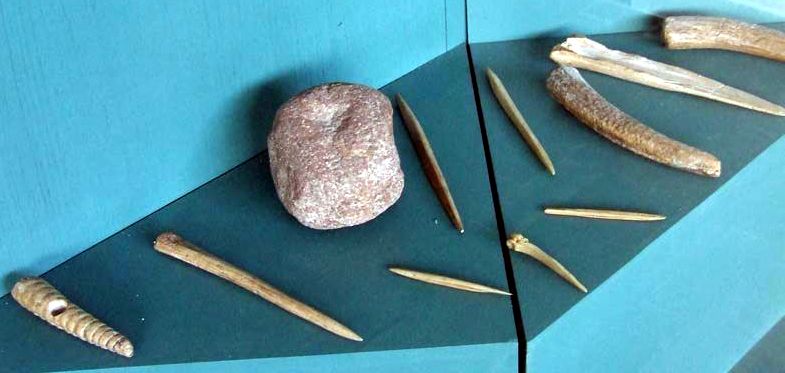
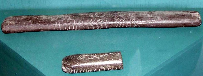
These photos of Lepenski Vir artefacts from the Museum in which they are housed are from:
http://outdoors.webshots.com/album/558132902opfLBE?start=12
Prehistoric fauna from Lepenski Vir
From: Bokonyi, S., 1970 'Animal remains from Lepenski Vir' Science Vol 167, pp 1702-1704
No = number of bones
Note that the dates below for the phases of Lepenski Vir are in dispute, and should be treated with caution. They are broadly correct.
| Phase I 5980- 5525 BC | Phase II 5490- 5200 BC | Phase III 5200- 5000 BC | |||||
| Taxon | Common Name | No. | % | No. | % | No. | % |
Domestic | |||||||
| Bos taurus | cattle | 375 | 15.8% | ||||
| Ovis aries | sheep | 81 | 3.4% | ||||
| Sus scrofa dom. | pig | 8 | 0.3% | ||||
| Canis familiaris | dog | 21 | 5.0% | 23 | 11.2% | 140 | 5.9% |
Wild | |||||||
| Bos primigenius | aurochs | 14 | 3.3% | 7 | 3.4% | 174 | 7.3% |
| Rupicapra rupicapra | chamois | 2 | 0.8% | ||||
| Cervus elaphus | red deer | 115 | 27.1% | 111 | 53.9% | 862 | 36.4% |
| Capreolus capreolus | roe deer | 4 | 0.9% | 1 | 0.5% | 36 | 1.5% |
| Sus scrofa fer. | wild pig | 10 | 2.4% | 6 | 2.9% | 211 | 8.9% |
| Asinus hydrunsinus | wild ass | 7 | 0.3% | ||||
| Felix silvestris | wild cat | 1 | 0.04% | ||||
| Lynx lynx | 6 | 0.3% | |||||
| Martes sp. | marten | 6 | 1.4% | 3 | 1.5% | 3 | .1% |
| Meles meles | badger | 3 | 0.7% | 7 | 0.3% | ||
| Ursus arctos | brown bear | 1 | 0.5% | 27 | 1.1% | ||
| Canis lupus | wolf | 7 | 0.3% | ||||
| Vulpes vulpes | fox | 1 | 0.4% | ||||
| Castor fiber | beaver | 2 | 0.47% | 4 | 0.2% | ||
| Lepus europaeus | brown hare | 7 | 0.3% | ||||
| Aves sp. | birds | 6 | 1.4% | 1 | 0.5 | 10 | 0.4% |
| Cyprinids | 86 | 20.3% | 1 | 0.5 | 14 | 0.6% | |
| Siluris glanis | catfish | 3 | 0.7% | 5 | 2.4% | 22 | 0.9% |
| Pisces sp. | fishes | 154 | 36.3% | 47 | 21.8% | 364 | 15.4% |
| ------ | ------ | ------ | |||||
| Total | 424 | 206 | 2369 |
Back to Don's Maps
Back to the Iron Gates
Proto Lepenski Vir and Lepenski Vir Ia