Back to Don's Maps
Back to Archaeological Sites
The Iron Gates - The Location of the Sharamudoi
Jean Auel has stated that the site of the Sharamudoi is based on an amalgam of a number of sites in the Iron Gates region of the Donau, and not on any one site. She had not heard of Cuina Turcului. The oldest site which could have been used as a model, and the only rock shelter site in the Iron Gates region is, however Cuina Turcului. It is closer to the original river level (8 metres, around 26 feet above the water) than Jean placed the Sharamudoi rock shelter. It is now under water after the construction of a series of dams in the Iron Gates section of the Donau.
The 'houses' under the rock shelter described by Jean for the Sharamudoi appear to be modelled on the trapezoidal shelters which were used at Lepenski Vir, an open air site on a terrace beside the Donau which was occupied in the Mesolithic, much later than the time outlined in the books by Jean Auel. The trapezoidal plan is common in the area, and also occurs at Vlasac and Padina. As noted below, on the basis of the evidence available, it seems clear that the whole sequence of sites in the Iron Gates architecturally looks like the work of a single population which continued through several thousand years to occupy this region.
Jean does not mention the sophisticated hearths and sculptures found at the Lepenski Vir site. There is absolutely no evidence for a floating dock on the Donau. However the Sharamudoi boats may have their origin in the reed boats of the Caspian Sea, with rock engravings dating to 10 000 BP.
 Go to the Iron Gates contour maps
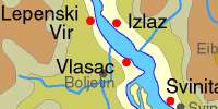
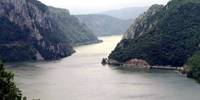
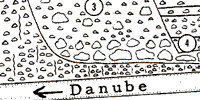
 Overview of the Iron Gates area
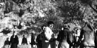
 Per's Iron Gates photos
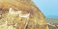
 Go to the Cuina Turcului site - the only rock shelter site in the region
 Proto Lepenski Vir and Lepenski Vir Ia- a mesolithic site on the Donau. Lepenski Vir is the name of the great whirlpool in the middle of Djerdap, the Iron Gates Gorge, and the nearby horseshoe shaped shelf between the right bank of the Danube and the steep cliffs of the Koršo hills. Lepenski Vir is a Mesolithic site - that means middle stone age, in this case 8 000 years before the present, after the ice had begun to melt from the glaciers which covered so much of the Northern Hemisphere. It is an open air site, not a rock shelter. It is noted for the trapezoidal houses which had one of the first types of concrete as their foundations. They inhabitants ate fish, aurochs, deer and water birds. Professor Dragoslav Srejović excavated the site of Lepenski Vir.
The prehistoric settlement was built on the sunny right bank of the Danube, between the steep slopes of the Koršo hills and the spring high water mark on the low porphyritic rocks which stretch down to the river.
Proto Lepenski Vir and Lepenski Vir Ia- a mesolithic site on the Donau. Lepenski Vir is the name of the great whirlpool in the middle of Djerdap, the Iron Gates Gorge, and the nearby horseshoe shaped shelf between the right bank of the Danube and the steep cliffs of the Koršo hills. Lepenski Vir is a Mesolithic site - that means middle stone age, in this case 8 000 years before the present, after the ice had begun to melt from the glaciers which covered so much of the Northern Hemisphere. It is an open air site, not a rock shelter. It is noted for the trapezoidal houses which had one of the first types of concrete as their foundations. They inhabitants ate fish, aurochs, deer and water birds. Professor Dragoslav Srejović excavated the site of Lepenski Vir.
The prehistoric settlement was built on the sunny right bank of the Danube, between the steep slopes of the Koršo hills and the spring high water mark on the low porphyritic rocks which stretch down to the river.
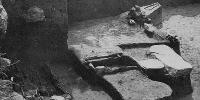
 Lepenski Vir Ib-e, II, III - a mesolithic site on the Donau. Lepenski Vir is the name of the great whirlpool in the middle of Djerdap, the Iron Gates Gorge, and the nearby horseshoe shaped shelf between the right bank of the Danube and the steep cliffs of the Koršo hills. Lepenski Vir is a Mesolithic site - that means middle stone age, in this case 8 000 years before the present, after the ice had begun to melt from the glaciers which covered so much of the Northern Hemisphere. It is an open air site, not a rock shelter. It is noted for the trapezoidal houses which had one of the first types of concrete as their foundations. They inhabitants ate fish, aurochs, deer and water birds. Professor Dragoslav Srejović excavated the site of Lepenski Vir. The prehistoric settlement was built on the sunny right bank of the Danube, between the steep slopes of the Koršo hills and the spring high water mark on the low porphyritic rocks which stretch down to the river.
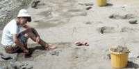 Schela Cladovei
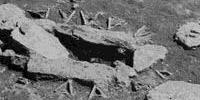 Padina
 Vlasac
 Hajducka Vodenica
 Gaura Chindiei - a limestone cave at the first Iron Gate
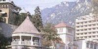 Baile Herculane - a limestone cave area with Paleolithic cave deposits
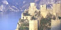 Golubac - a 13th Century castle guarding the Iron Gates entrance
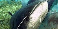 Animals of the Iron Gates
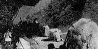 Old engravings of the Iron Gates
 Sharamudoi boats from the Caspian Sea